
Trust

How Deploy Solutions can help bridge the communications gap in times of climate change crisis
Our Changing Climate The world we live in is changing, with global warming reshaping climate and causing more frequent, more…
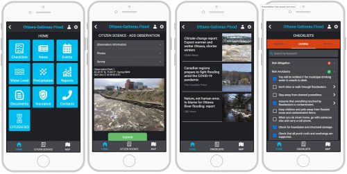
Building Software Solutions for Climate Change: Closing the communication gap between citizens and trusted authorities before, during, or after a disaster
A Climate Change Problem: The Communication Gap between Citizens and Authorities At a time of rising climate change impacts, there…

Geospatial Earth Observation Using Blimps, Balloons and Kites
These days drones are all the rage. Nevertheless, there are other ways to collect data from the sky! Blimps, balloons and kites…

A List of Geospatial Open Data Resources in Canada
Recently, I read an article about the Canadian Geospatial Data Infrastructure (CGDI) that seeks to explain why the CGDI, among many…
Canada Takes Part: Arctic Spatial Data Infrastructure Meets in Anchorage
The Arctic SDI Board, which includes mapping executives from Canada, Kingdom of Denmark, Finland, Iceland, Norway, Russia, Sweden and the…
The Real Thing: Robert Maher Examines the Book “The Real Thing” by Briony Penn
Over Christmas, I had the opportunity to go ‘off island’. One of the pleasures of visiting Victoria, British Columbia is…
GIS: Adventures in Historical Mapping
This article focuses on the process of creating a very out-of-date map in GIS. Lots has gone on since I…
Elevation Web Services: Limitations and Prospects
Elevation Web Services: Limitations and Prospects Elevation data is necessary for a wide range of geospatial applications such as creating…

Canada Day Came Early at the Canada Aviation and Space Museum
June 23rd marked a special day in the history of aviation and space in Canada. A very special aircraft, a…

Grow or Die – 3 Key GIS Career Needs
The premise of a liberal arts or science degree is to get a wide range of exposure across several disciplines. …
Phase One Industrial and SimActive, Inc. Announce Integrated Software Solution
COPENHAGEN and MONTREAL April 22, 2015 –Phase One Industrial, a leading manufacturer and provider of medium format aerial and industrial…
BC Assessment Wins Award for Transforming Property Assessment Using GIS
Geospatial solutions improve accuracy and access to property information VICTORIA, Esri Canada User Conference – April 15, 2015 – BC…
