
vehicle
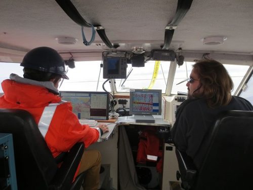
Geomatics: Discovering history in Canada’s Arctic waters
This article was reprinted with permission from the Ontario Professional Surveyor, Volume 56, No. 3, Summer 2015 By Theresa Nicholsi,…
Montreal: AeroVironment Chooses SimActive’s Correlator3D™
Montreal, Canada, September 22nd, 2015 – SimActive Inc., a world-leading developer of photogrammetry software, is pleased to announce that AeroVironment…
A Canadian Perspective: Idiots who use Drones
In the past few months there have been quite a few articles that have shown UAV’s or drones in a…
New Online Publication: Drone Coalition
An exciting new online publication, Drone Coalition, launched in conjunction with the InterDrone 2015 Conference and Exposition in Las Vegas,…
2005-2015: Ten Years with Google Maps
In February 2005, Google Maps was launched as a desktop web mapping service. A few months later, in June 2005,…
Global Commercial Drone Market to Reach $2.07 Billion by 2022
The global commercial drone market size is expected to reach USD 2.07 billion by 2022, according to a new report…

UAV-g 2015 Conference: sUAS for Geomatics
The third international conference on Unmanned Aerial Vehicles in Geomatics (UAV-g 2015) is coming to Canada later this summer for…

PredictION: Routing & Modeling App for Proposed Transit Projects
PredictION is an app that provides transit authorities with a unique approach to engage and inform the public. By making…

Learn about UAVs at the Ottawa June Social
This is the last month for GoGeomatics Socials before we break for the summer, and in Ottawa we’re going out…
Seisland Surveys Wins Esri Canada’s Award of Excellence in GIS
Cloud-based oil and gas information management solution supports effective emergency response CALGARY, Esri Canada User Conference – May 27, 2015…
Ville de Montréal Wins Award for Innovative Snow Removal Mapping Application
Cloud-based mobile app communicates real-time snow removal information, enabling citizens to effectively plan around parking restrictions QUÉBEC, Esri Canada User…
Remote sensing sheds light on Earth’s surface at UVic
The University of Victoria is partnering with the province to develop new ways of using airborne sensors to gather information…
