
website

EnerGIS 2017: Call for Papers & Scholarship Opportunities
EnerGIS 2017 6/5/2017 to 6/6/2017 Suburban Pittsburgh, Pennsylvania. Join us for our 5th annual conference June 5th and 6th 2017!…

Top Ten Climate Change Maps and GIS Applications
Awareness for climate change has been steadily increasing ever since the Green Revolution in the 1960s. There is a plethora…

Event Recap: COGS & CIG & GANS Cooperate for Mapping Workshop
The Canadian Institute of Geomatics (CIG) Nova Scotia Branch and the Geomatics Association of Nova Scotia (GANS), two regional professional organizations that foster the application of geographic information within the geomatics sector recently collaborated to host a high resolution mapping workshop at the Centre of Geographic Sciences (COGS) in Lawrencetown, Nova Scotia.

Call for Papers: CAG: Critical Geographies of Migration
Please consider submitting an abstract for the CAG 2017 York University, May 29 – June 2, 2017. The last day to submit…

Interview with Sam Scovill, GIS Technician and 3 Day Champion on Jeopardy
Every weeknight, my mom and I watch Jeopardy together. Jeopardy always starts with the announcement of the contestants by their…

Software Development – The Key to Ecere’s Success
It is rare to learn of a GIS company in which much R&D is done up front to create the…

Upgrade your Geospatial Skills: leveraging the power of MOOCs
What I want to share with you are some resources related to something called Massive Open Online Course (MOOC) where…
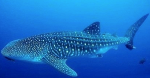
Marine Geomatics Primer: Using UUVs to Take Flight Underwater
Unmanned Underwater Vehicles One of the most interesting things to happen in regards to marine geomatics technology has been the…

The Future of GIS Software? QGIS A Popular Open-Source GIS for the Masses
In today’s geomatics society, ArcGIS, developed by Esri, is a giant and dominates the GIS software market. However, there are…
Scholarships Available for Geomatics College and University Students
The Canadian Institute of Geomatics (CIG) administers a number of Scholarship and Award programs that are oriented towards promoting the…

Feb 7-8: Two Day Workshop on High Resolution Mapping Along Coastal Zones
The coastal zone, that dynamic geographic region where the interaction of the sea and land occurs, is vital to the…

Interview with Ted Mackinnon: Promoting Canadian GIS & Geomatics on Twitter
GoGeomatics has been actively using Twitter to reach out to the geospatial community since 2009. We have written and hosted…
