
Using GIS to Examine Leapfrog Development Beyond the Ontario Greenbelt
Since its establishment by the Ontario government in 2005, the Places to Grow Act is a policy envisaged at curbing the effects of urban sprawl and encouraging population growth where it is needed. According to the Ministry of Municipal Affairs and Ministry of Housing website, the greenbelt extension of the Act protects 1.8 million acres of environmentally sensitive and agricultural land, and includes 800,000 acres already covered by the Niagara Escarpment Plan and the Oak Ridges Moraine Conservation Plan; the law aims to densify existing built-up areas through the development of mixed-used and pedestrianized communities. Such built-up areas are spread throughout the Greater Golden Horseshoe (GGH) and include the municipalities of Toronto, Vaughan, and Hamilton (See Figure 1).
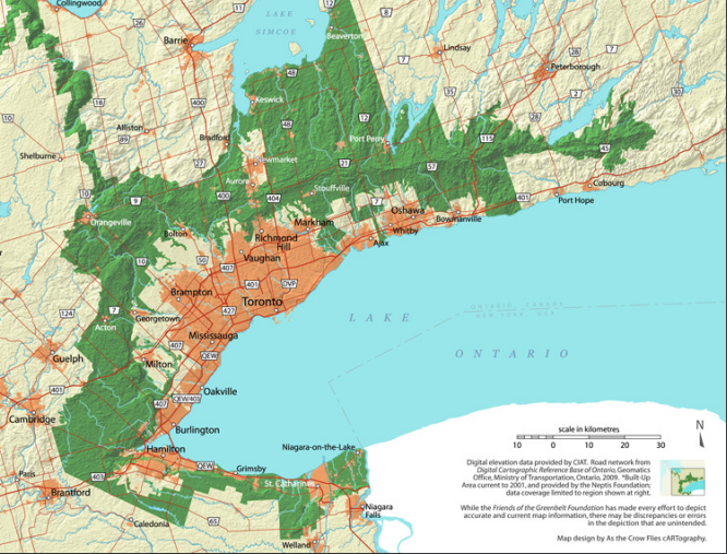
Figure 1: The 2005 greenbelt plan and its inner municipalities. Image courtesy of Friends of the Greenbelt Foundation.
While the Places to Grow Act has been successful in densification, including the recent explosion of high-rises in Toronto, the new greenbelt restrictions had curtailed home developers to continue building new subdivisions on the edge of existing GGH municipalities. In response to land speculation and high housing prices in the GGH, developers began to build low-density, car-dependent subdivisions in municipalities beyond the protected landscape, a development practice known as leapfrog development. Yet there is insufficient visual evidence of the practice occurring over the past decade, and thus the utilization of image classification can indicate the amount of sprawl that has occurred in communities outside of the greenbelt.
Methods of Image Classification
Simcoe County was selected for this study (see Figure 2) as the region underwent the fastest decadal population growth out of other regions beyond the greenbelt (see Table 1), providing an ideal demonstration of urban change over time.
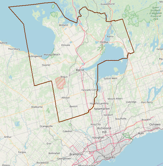
Figure 2: Simcoe County (highlighted in mahogany) in relation to the Greater Golden Horseshoe (GGH). Image courtesy of Open Street Map.
Table 1: The 2006 and 2016 population for regions beyond the Greenbelt, as well as their rate of population change and ranks. Source: Statistics Canada Census Profile
| Rank for Population Change (#) | Region | 2006 Population | 2016 Population | Population Change |
| 1 | Simcoe County | 422,204 | 479,650 | 57,446 |
| 2 | Waterloo Region | 478,121 | 535,154 | 57,033 |
| 3 | Wellington County | 200,425 | 222,726 | 22,301 |
| 4 | Niagara Region | 427,421 | 447,888 | 20,467 |
| 5 | Brant County | 125,099 | 134,808 | 9,709 |
| 6 | Dufferin County | 54,436 | 61,735 | 7,299 |
| 7 | Grey County | 92,411 | 93,830 | 1,419 |
| 8 | Haldimand County | 45,212 | 45,608 | 396 |
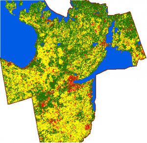
Although population growth in Waterloo Region was nearly equivalent to Simcoe County, change detection results over the former may not be too significant due to its relatively small size. Two satellite images of the area were acquired from the USGS Explorer website on September 11th, 2005 and September 12th, 2017, where unsupervised classification was performed on ArcGIS for the 2017 image. Four classes were created for the unsupervised image: urban area (red), agriculture (yellow), forest (dark green), and water (blue) (see Figure 3). Once the image was converted from raster to vector, three of the four classes were deleted with reference information from Google Earth, leaving only the urban area class polygons. The urban class polygons were further deleted on top of the 2005 satellite image to reflect change over the past twelve years. Finally, the altered image was overlaid onto an OpenStreetMap layer.

Figure 3: Unsupervised classification result of Simcoe County.
Image Classification Results
According to Figure 4, many municipalities within the southern half of Simcoe County has experienced substantial urban sprawl between the years 2005 and 2017. Such communities, including Bradford, Alliston, Angus, and Barrie, are proximate to major Highway 400 and arterial roads (e.g. Highway 89) These viable transportation options are highly accessible to the Greater Toronto Area and provided developers an incentive to build new subdivisions over the past decade.

Figure 4: Urban sprawl in the southern half of Simcoe County, 2005 to 2017.
To the northwest of Barrie, the communities of Collingwood and Wasaga Beach have also encountered significant land use change over time and this can be attributed to a major road linking to Highway 400 (Highway 26) and their proximity to the scenic Georgian Bay and Blue Mountains (Figure 5).
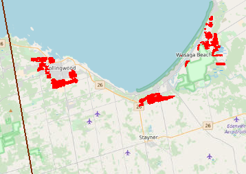
Figure 5: Urban land use change in the communities of Collingwood and Wasaga Beach, 2005 to 2017.
Sprawl has also occurred at the northern half of Simcoe County, albeit not as significant as the southern half. Although changes were noteworthy in the municipalities of Orillia and Penetanguishene, other communities have experienced little to no sprawl given their greater distance from the GTA when compared to their southern counterparts (Figure 6).
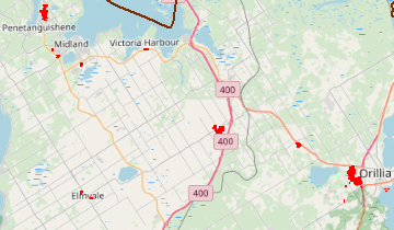
Figure 6: Urban sprawl in the northern half of Simcoe County, 2005 to 2017.
The above Figures and image classification discussion has visually demonstrated the growth of auto-dependent subdivisions in communities beyond the greenbelt, a result of land speculation, high prices in the Greater Golden Horseshoe, and a development practice that runs contrary to the intensification objectives of the Ontario Places to Grow Act. In response, the Ontario government is currently working on updates to the plan, including possible expansion of designated greenbelt land to preserve water systems in regions outside of the original plan. Despite the impending changes, future study would be important to examine what effect the updated policy would have on leapfrog development in Simcoe County and other outer regions.