
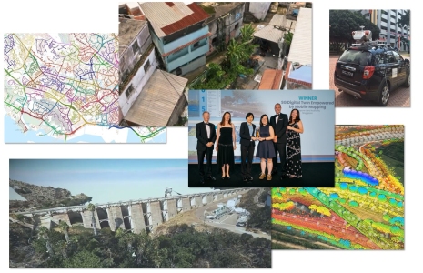
Surveying and Monitoring Shine at the Year in Infrastructure Awards
The winner and finalists in a new award category exemplify advances in the digitalization of AEC and infrastructure
2022 saw the addition of a new category in the annual Year in Infrastructure – Going Digital Awards: Surveying and Monitoring. It is great to see the vital role of surveying and geomatics highlighted in these prestigious awards.
Selecting from global nominations for categories representing innovation in key aspects of the digitalization of AEC and infrastructure, this is one of, if not the, premier annual global infrastructure awards program. Categories focus on infrastructure industry sectors, that include transportation, energy, facilities, and more, in any phase of infrastructure lifecycles—planning, design, construction, and operations.
Finalists presented their projects before an expert panel of jurors, and attendees of the Year in Infrastructure event, hosted by Bentley Systems, held in London, 14-15 November 2022. Winners and finalists were honored at the gala Going Digital Awards dinner and will be featured in the annual Infrastructure Yearbook.
You can check out the finalists for each of 12 categories, but we’d like to highlight the finalists and winner in Surveying and Monitoring. While all finalist projects themselves are impressive often from sheer scale and scope, what these awards focus on is the benefits realized by digitalization of various aspects of the projects, through the use of modelling, visualization, analysis, project management, and collaboration.
WINNER: SG Digital Twin Empowered By Mobile Mapping – Singapore
The government of the city/state of Singapore continues pursuit of a fully 3D reality smart city/nation. This winning project is the second phase of nationwide digital mapping that began with aerial mapping in 2014 and mobile mapping in 2015. While some maintenance mobile mapping was done in 2017, and new aerial mapping in 2019, it was the all-new mobile mapping completed in 2022 that stands out in terms of precision, completeness, and additional technical elements.
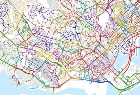
5,500 km of public roads in the city/nation of Singapore were mobile mapped in the course of this project.
Sandy Teo, a senior surveyor with the Singapore Land Authority (SLA), explains the role of SLA in the project, and goals for the initiative: “SLA is a government agency that optimizes land resources for the economic and social development of Singapore. As many of you may know, Singapore is a small island. This is important as limited land must support a useful, wide range of activities. SLA is also in charge in managing authoritative land related information and drives the adoption of geospatial information within the government and the industry.”
The focus of this campaign was to complement and provide more detailed mapping at ground level. For this most recent round of mobile mapping, SLA employed a high-end system; a Riegl VMX-450. The laser scanner mounted on the vehicle was deployed on the street to capture a million points or more per second. Lidar is coupled with six highly sensitivity five-megapixel image sensors covering 90% of a full sphere. 360-degree panoramic images were captured at 20-meter intervals. This provided the city a of a minimum of 40 points per square meter at ground level.
“In total, we have covered 5,500 kilometers of public roads covering the entire country, including the island of Sentosa,” said Teo. “The mobile mapping campaign includes point clouds encompassing 600 billion points and 3 million panoramic images—25 TB of data.” This huge data set was then processed and classified. To manage and share this massive amount of data, SLA turned to the Bentley Orbit 3DM solution, that in addition to processing and other tools, optimizes and delivers the data through a web portal. They also use the Orbit 3DM tools for classification and feature recognition.
“All projects face challenges, and our mobile mapping campaign is no exception,” said Hui Ying, of the Singapore Land Authority. “Our challenges include the sharing of high volumes of point clouds and images to users; and scaling for more in the future. We also needed to process the data to deal with captured noise and occlusion from objects in the point cloud. Also key is consideration of privacy, where human faces and vehicle number plates may be captured, and those needed to be [obscured].” The tools for such “anonymisation” were not as sophisticated in years past explained Ying, but that the current AI-driven tools to protect privacy proved very efficient.
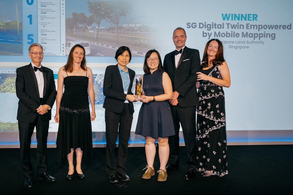
The SG project and team were honored as winners in the Surveying and Monitoring category of the YII 2022 Going Digital awards. Hui Ying and Sandy Teo of the Singapore Land Authority (center).
“The gap between data and end-user application, the updated use of the data sets must include integration of multi-resolution, multi-accuracy and multi-format mapping data from other sources,” said Hui Ying. “And the solution has facilitated and streamlined some of our challenges. The most apparent was the sharing of huge volume of data sets to users through web browsers to navigate the data. And to establish workflows to publish in an environment that has functionalities to perform feature extraction and measurements in three-dimensional space, bridging the gap between data and application.”
The sheer scope of this project is impressive, yet that alone was not the sole reason for winning in the category. The approach taken to mapping, data management, and data sharing were well thought out and executed. Plus the steps taken to ensure that other data can be federated. “Integration of data such as those from aerial drones, and on portable devices will warrant further studies and review to ensure overall data integrity,” said Hui Ying. “The investment in such a nationwide campaign allows more users to adopt such digital data and technology to re-engineer and transform conventional workflows.
Cost savings for such a project are substantial. SLA estimated that traditional ground based topographic surveys, to cover all public roads in Singapore, would have cost about $30 million SGD ($25 million USD) and would have taken over two years to complete. With mobile, this current nationwide mapping campaign took a year, and cost $4.5 million SGD ($3.4 million USD). Pre-planning was key; routes were selected to ensure that loops could be closed each day. Mapping continued from 7:00am to 7:00pm daily during the survey.
In their presentation to the awards jury at the event, Teo and Hui Ying touched on many of the envisioned benefits, and some that had already been realized from the early phases. They emphasized one particular future goal: to develop more complete documentation of underground structures digitally, to better facilitate the underground master planning of Singapore. “Users can access the mobile mapping data served through the [Orbit 3DM portal], to help in the digitalization of underground assets,” said Teo. “In addition, to identify potential areas of flooding especially at low tunnel portals, and ensure critical infrastructure are protected from sea level rise and climate change.”
This project is another example of how Singapore is viewed as a global leader in many aspects of 3D digital reality, digital twinning, and geospatial innovation.
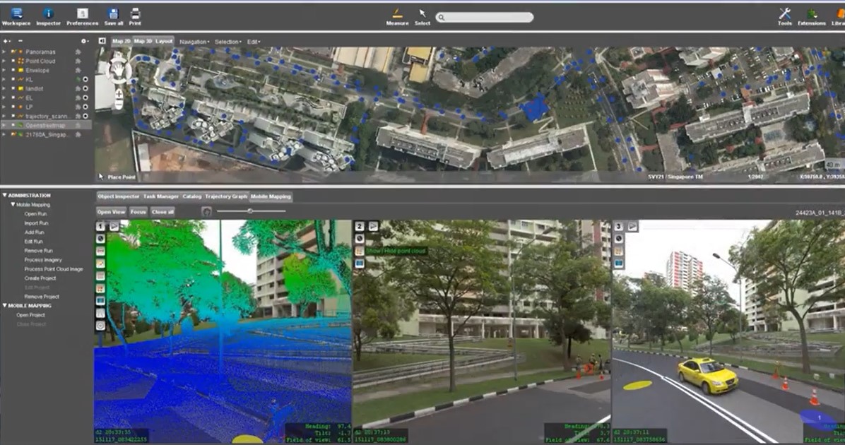
View of the interface for the mobile mapping operations during field capture.
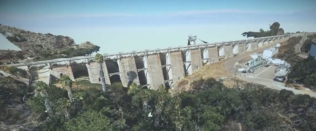
FINALIST: HDR – Murray Dam Condition Assessment – USA
Monitoring of structures like dams and bridges is time consuming, costly, hazardous, and legacy methods may only provide limited samples of data. HDR and their client have taken the approach of developing a digital twin for the purposes of condition assessment of the dam at the Lake Murray Reservoir in Sand Diego County, USA.
The digital twin of Murray Lake Dam as developed by HDR in a survey that included terrestrial and UAS scanning and imaging; here shown as a meshed model.
HDR combined UAS images and terrestrial scans to produce a high-precision 3D meshed model digital twin to which multi-sourced data is attached. This is a valuable complement to manual inspections and helps analyze future issues. While models like this would not directly replace structural health monitoring sensors and mandated deflection surveys, being able to eventually combine all data in a digital twin is a welcome prospect.
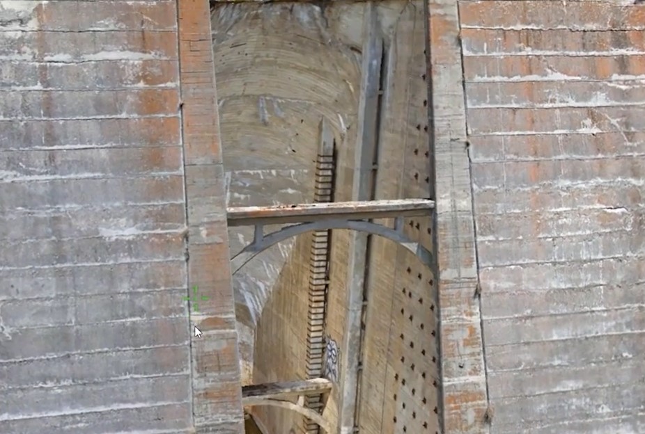
These bays in the dam are a challenge to inspect with rope teams, as they extend back at 45-degrees. Using terrestrial scanners, and drones, a detailed model was created, to help inform monitoring operations.
“Data collection presented several challenges given the complexity of the structure,” said Carlos Femmer, director of data acquisition at HDR. “Certain areas of the dam were difficult or impossible to reach by rope access. For example, the interior sections of the dam have extremely narrow access points. Furthermore, the bays extended back at the at a 45-degree angle, not ideal for rope access. This is just one instance of our drone capabilities adding value to the overall effort.”
Lidar data was captured by registered surveyors using the Trimble X7 and Trimble SX10 scanning total stations. They collected millions of data points from multiple scan stations and different angles. This data was geo referenced with survey data in conjunction with known monument points at the site. HDR utilized Bentley Context Capture for elements of the modelling process.
“Because [GNSS] positioned drones could not be used for multiple portions of the structure, we utilized Skydio 2 and X2 drones, which used a visual positioning system to autonomously capture a majority of the exterior façade,” said Femmer. “And capturing the enclosed portions of the dam as required, reaching heights more than 100 feet above the ground level with little room to maneuver and a very small margin for error. For these sections, we also utilized a Flyability Elios drone. When all was said and done, we captured more than 25,000 high resolution photos and more than 1 billion lidar points over the course of four days on site.”
With this complementary approach collecting and processing a comprehensive data set, that rope inspection teams can access before setting foot onto the project site, exemplifies the benefits of a collaborative multi-pronged approach. HDR emphasizes that this was never intended to replace rope inspections; instead, the digital model informs, and special work can be scheduled and performed. This hybrid approach yields substantial cost savings compared to traditional processes.
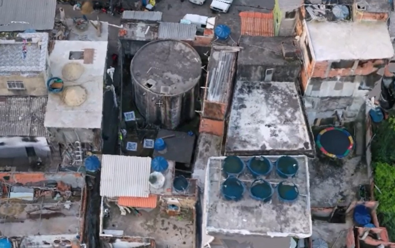
FINALIST: AEGEA – Brazil’s Largest 3D Sanitation Map (Digitalization Of Rio De Janeiro)
Presenting the project for the awards’ judges was Wagner de Carvalho, lead for the Infrastructure Intelligence Program of AEGEA, a company that manages the sewerage for much of 178 municipalities in 13 states, with 26 million clients in Brazil, and is the largest private water dealer in the country. The large-scale survey they undertook is seen as a key enabler of more efficient operation of these expansive systems, and for design of upgra’es that can, among other goals, help clean the waters of Guanabara Bay (adjacent to Rio de Janeiro).
“We faced a huge gap in data when we took over these sewerage systems,” said de Carvalho. “In 2020 Brazil established a new framework and regulatory framework, the quality institution regulations are now facing a new scenario.” The approach AEGEA took was the to correlate massive amounts of newly captured data to make the operations processes more efficient with improved currency and accuracy and faster review times.
AEGEA had limited time to perform the surveys—only 130 days—and what they found was that there were 400 more plants (sewer facilities and systems, both passive and active) than the expected 900 plants. “For instance, we generated more than 10,000 pictures, oblique the vertical images from 30 meters to 300 meters high to have GSD (ground sample distance) in the centimeter range,” said de Carvalho. “This highly detailed data revealed a lot we did not previously know about the systems.”
“For the four components of a digital twin, our fiscal system, a model, and real-time insights, we have used several basic tools to build models,” said co-presenter Waldo Bitencourt, civil and environmental engineer with AEGEA. “We then imported them into the Unity platform to build the digital twins.” Unity is a platform that is also popular in the gaming industry and is suited very well for such large-scale mapping purposes. “At the end of the implementation, we have identified more than 29,000 assets with around 11 million attributes,” said Bitencourt. “In more than 4TB of reality capture data, we were also able to estimate the assets position in its lifecycle. Interconnectivity was a key factor for the maintenance of database reliability in data flows, or by interactions between the different departments and management software used by the company.”
AEGEA performed the mapping for this massive project in 130 days, using drones and ground targets that included scan codes to ensure fidelity between the data and features captured.
Much of the data was captured by drones, with AEGEA employing ground targets with large scan codes to ensure fidelity between the digital products and the features on the ground.
“We were able to implement a solid foundation to preventive and predictive maintenance, insurance, price reduction, improvements, and critical assets,” said Bitencourt. “This enables precise interventions in infrastructure, creation of precise digital twins and improvements in relationships with the regulatory authorities.”
AEC and Infrastructure Wins
It might be cliché to say that all finalists deserved to win, but it is true, all deliver great benefits for clients and stakeholders. The same could be said of the dozens of nominated projects, in this category and others. When it comes to the goal of further digitalization of AEC and infrastructure design, construction, and operations, that such projects are becoming so common around the globe speaks to the value of innovation in software and hardware employed. And it is heartening to see surveying and monitoring highlighted as a new awards category, as the massive amount of reality capture ahead can benefit from those with the skill and expertise required.
Note: YII is a Bentley sponsored event, and all YII 2022 Going Digital Awards nominee, finalist, and winner projects feature the use of one or more Bentley Systems software packages.
