Your International Geospatial Briefing for November 4th: Is geospatial data the key to leaving no one behind?; OGC updates IndoorGML standard; Observing California’s Wildfires from the Space Station; Major Wood Chip Exporter Now Prefers Drones to Calculate Volumes
Is geospatial data the key to leaving no one behind?
Some of our planet’s leaders may still be deliberating the existence of global warming, but for the communities experiencing this very real issue, the only thing on their mind is survival.

For situations like these, geospatial data can be used to help. “Geographic information systems allow scientists to capture, store, and analyze data on different aspects of a geographical point… Integrating technology into traditional problem-solving enables us to be proactive, rather than reactive, in these efforts”.
NCDC, Nigeria Centre for Disease Control, already uses digital solutions to help with health outcomes. They make data-informed decisions to assist in response team coordination and to better analyze risk.
Visit the Turning the Tide series here for more coverage on climate change, resilience building, and innovative solutions in small island developing states.
Opinion: Is geospatial data the key to leaving no one behind?
OGC updates IndoorGML standard
Prior to approval of the OGC update to the IndoorGML standard, OGC is seeking for public comment.
IndoorGML has stated that the goal is “ to represent and allow for exchange of the location information required to build and operate indoor spatial services such as indoor navigation systems. Several standards, such as CityGML, KML, and IFC, have been published to describe 3D geometry and semantics of buildings for outdoor/indoor spaces, but they lack some important features that are specific to indoor spaces”.
The candidate IndoorGML v1.1 standard is available for review and comment on the OGC Portal. Comments are due by 29 November, 2019, and should be submitted via the method outlined on the IndoorGML v1.1 standard’s public comment request page.
OGC updates IndoorGML standard to v1.1; seeks public comment before approval
Observing California’s Wildfires from the Space Station
The International Space Station has captured imagery of the California wildfires.
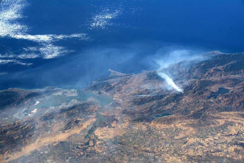
Photo Taken by NASA
Did you know that NASA’s satellites are often the first to detect wildfires in remote regions? “[NASA sends] the locations of new fires are sent directly to land managers worldwide within hours of the satellite overpass… NASA has a fleet of Earth-observing instruments, many of which contribute to our understanding of fire in the Earth system. Satellites in orbit around the poles provide observations of the entire planet several times per day, whereas satellites in a geostationary orbit provide coarse-resolution imagery of fires, smoke and clouds every five to 15 minutes”.
Observing California’s Wildfires from the Space Station
Major Wood Chip Exporter Now Prefers Drones to Calculate Volumes
Terra Drone Australia was recently hired by Bunbury Fibre Esports Pty Ltd. To aid in the calculation of the volume of their stockpile of Blue gum wood chips.
In the past, the stockpile use to be calculated with real-time kinetic surveys. This mean that the surveyors would have to climb the stockpiled and conduct spot measurements with GPS equipment. It was a slow and expensive process.
Now Terra Drone Australia is using a multirotor drone. The “calibrated camera is used to take hundreds of downward looking images across the stockpile. A dense point cloud is computed from the image data using Agisoft Photoscan photogrammetry software. The point cloud is then cleansed of above ground features (conveyors) and noise using geometric filters, before having a high-resolution surface digital elevation model produced. From here a volume accurate to less than 0.5% can be produced”. The best part is that this method is estimated to be 60-80% faster, therefor also being more cost effective.
Major Wood Chip Exporter Now Prefers Drones to Calculate Volumes