

3D Reconstructions of Ancient Cities
As cities grow outwards and upwards over time, we most often forget what lies underneath what is on top. While not all cities from Antiquity have survived into the present day, the ones that have present an intriguing opportunity for understanding how they developed into what they are now. To demonstrate how ancient cities have become how they are seen and experienced today, I have been using Esri’s CityEngine city building software to reconstruct what was the past in the present.
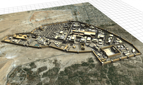
What originally began as a project to map out all damaged and at-risk heritage sites across the Middle East since the turn of the millennia developed into a focus on one of these such sites- that of Palmyra in Syria. This focus came about with my discovery of CityEngine and wanting to reconstruct the city as it was circa 300CE as a part of the Roman Empire at the time. I relied on primary and secondary literature, previously produced maps, and present-day imagery, as well as some artistic license where data was lacking in tandem with the software’s tools to gradually build the city. Over the course of almost 22 hours, I built the city through trial and error, which included hundreds of columns and the texturing process. Once completed, I produced a modern-day representation of an ancient city through the use of a 3D GIS program that would eventually allow people to see what it looked like before the city’s inhabitants moved away.

Palmyra- circa 300CE
Seeing what could be accomplished with CityEngine, I later followed up Palmyra with my second and most complex ancient city yet- Constantinople circa 600CE. Following the same process as my first city but now with elevation and the circle polygon tool at hand, I gradually constructed this city over another 22 hours. This time however, several more hours were required for the texturing process due to the 8,000+ objects within the model. This eventually completed city portrays what Constantinople was like at this time compared to how the modern version of the city has expanded well outside of the former defensive walls. This city has most recently been accompanied by my third ancient city, Athens in 431BCE, which will stand in size between Palmyra and Constantinople. This city clearly demonstrates how Athens used to look almost 2,500 years ago, and how it has developed and expanded over time. For example, the Long Walls section connecting Athens proper and its harbour, the Piraeus, were torn down long ago but two city streets now run over the exact locations of these walls. It is details and visuals such as this that demonstrate how these 3D reconstructed cities can be used to show and teach people how our cities have and will continue to develop into the future.

Constantinople- circa 600CE

Athens- 431BCE
This understanding has most recently been expanded to see to what extent I can reach people so as to be able to show them this aspect of human history. The two pictures below are of Constantinople and Athens in Google Earth after the idea was suggested to me after my GoGeomatics talk back in March. While there remains some bugs that need to be fixed, their importing into this widely available program is a resounding success that has demonstrated how GIS and 3D GIS programs can be used to recreate the past in order to preserve it in the present for our future to come.

Constantinople- circa 600CE in Google Earth

Athens- 431BCE in Google Earth


Wow! Is this the first time this has been done?
Thank you! Well I’d like to say that it is but the CityEngine team previously built Pompeii and a Medieval town, and the program has the ability to export constructed cities into 3D design software such as Unreal Engine Studio and Blender as well as into other formats. However, I am building and texturing these cities from scratch based on historical records and archaeological knowledge rather than having them procedurally-generated. This allows me to be more precise and historically accurate with each building, wall, and monument. I am also working towards publishing them into VR and Google Earth to allow for more people to experience them first hand.
That’s pretty cool!
Hell, nice!
I’m in search for a Constantinople Pic from the northern side. Are your models in a format that i could generate the view i need?
Hello there, and thank you!
Right now I don’t have my models publicly available but I can send you the pic/s you need of Constantinople that I already have if you’d like?
Hell, the subscription system is REALLY confusing, guess, i’ve kicked me out by myself. Well, the best view was to get it from northern to the northern gate which would lead along the aethius cisterna, later to the philadelphion within the city.
Just like a horseman could see this.
I understand. Well if you would like to send me an email where we can talk further about this, I can hopefully get what you need
U/mm, OK, my address is ibp@gmx.at. Let’s talk about getting a draft how it probably was kinda so thereadays.
Hi, The Constantinople model has some major inconsistencies with the reality. There are many reclamation areas and the biggest one (southern central part) was built in 2012. I suggest you to to remove the structures on these ares and use an older imagery or at least indicate this issue to avoid any misinterpretation.
Hello there. Yes, when I originally built this it was for a university course final project where I was under constraints to finish it so I built it as am amalgamation of the past and present of the city, while more so focusing on showing what CityEngine can do for Historical GIS. My new version of Constantinople cir.500-600CE that I have been working will be more historically precise when I finish then release it so stay tuned for that!