

A Japanese Perspective: LiDAR forest data for resource analysis in Japan
The GIS & LiDAR Specialist
I am Kei, a passionate GIS & LiDAR Specialist with over 6 years’ experience in Japan, currently living in Canada and looking to continue my career here.
As I have not worked on any Canadian projects but have extensive experience working across the pacific on LiDAR projects, I hope you will find it interesting how LiDAR is done in Japan.
My GIS journey began 15 years ago when I started my geography science study at Beijing Normal University as a bachelor student and was excited that geography students could conduct field trips more than other majors.
During my 4 years of study, I have taken various courses such as Surveying and Cartography, Geographical Information System, Remote Sensing Principals and Interpretation, Geostatistics and Microwave Remote Sensing.
A growing interest in remote sensing
Gradually, I found myself deeply interested in remote sensing data processing and its application to natural resource management. This led me to take a Master’s program in Environmental Remote Sensing and geospatial analysis at Chiba University in Japan.
I gained a deeper knowledge of modelling large-scale time-series Remote Sensing data for land cover mapping and forest cover change detection. This was applied in my thesis on Land cover change detection using multi-temporal MODIS data for Eurasia. My research object was to develop a more efficient way to analyze land cover change detection, particularly for forest areas using large scale, row resolution data.
Gaining experience
After graduation, I started to work in Asia Air Survey Co., Ltd (https://www.ajiko.co.jp/en/) Forest consulting department and gained six years of experience with forest resources LiDAR data analysis related projects.

I have learned how to manage high resolution, big volume LiDAR data, conduct treetop detection, forest state evaluation, forest resource digital mapping, and consultation on sustainable forest management projects
Relocating to Canada
Now I am in Canada because I am fascinated by Canada’s natural wonders around every corner, from the beautiful mountains to coastal views. As a geography and forest LiDAR data analyst background, this is definitely a great place to explore, work, and living with family.
As my passion and skills directed me towards LiDAR data analysis related topics, I have been looking for open-source LiDAR data and GIS communities in Canada to learn about the utilization trend of LiDAR data in forestry; luckily, I have found GoGeomatics Canada, the largest community for GIS and came to know about the latest LiDAR technologies and industries.
My work with LiDAR
I would like to share my experience and the advanced technology that I engaged in forest LiDAR data analysis projects in Japan through this platform. I believe that what I learned in my past job experience is a treasure in my career life, and I am eager to use my GIS&LiDAR knowledge in the way forward.
In Japan, the need to utilize airborne LiDAR measurement technology has expanded dramatically in the forestry fields, such as forest resource analysis, development of harvesting support, forecasting the amount of woody material output, road network planning, and mountain disaster as it can be used to understand complex forest structures and generate accurate forest resource information.
It is necessary to utilize LiDAR in forest management because the mass amount of un-harvested forest resources and lack of forestry labour in Japan results in noticeable devastation in forests that cannot function in the public interest and are prone to sediment-related mountain disasters due to damage from typhoons and heavy rains.
Governmental organizations and companies are collaborating to maximize the utilization of LiDAR data both in Infrastructure information and forestry. Here are several advanced techniques generated by Asia Air Survey Co., Ltd (https://www.ajiko.co.jp/en/), where I have learnt unique technologies and know-how to acquire, analyze, and manage LiDAR data to support forest management.
Analysis of forest resource information
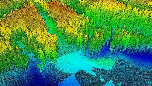
Digital canopy surface model (DCSM), digital elevation model (DEM), and Digital canopy height model (DCHM) are the main processed production of airborne LiDAR data. By analyzing DCHM, forest resource information such as tree species, tree height, volume, and standing density can be grasped efficiently and accurately.
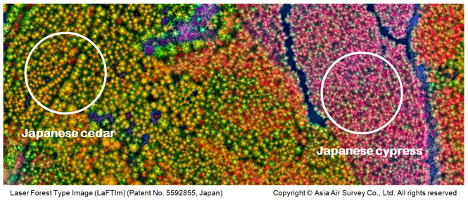
In the analysis, a forest phase map is first created to understand the distribution of tree types. In the conventional method, the forest phase map is created by interpreting Ortho-images where the interpretation is often difficult for cloud shaded areas, joint parts of photos, and high gradient photos.
To acquire high accuracy forest phase image efficiently, a Laser Forest Type Image (LaFTIm) was generated (https://proceedings.esri.com/library/userconf/proc14/papers/644_132.pdf). It is possible to easily distinguish tree types as different tree appears in unique colours and texture, whereas in ortho-image both tree types appear in green colour.
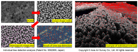
Individual tree detection
In the next stage, individual tree detection (https://www.ajiko.co.jp/products/detail/?id=14490) will be performed for planted forests such as Japanese cedar, Japanese cypress, and Japanese red pine; the position and height, diameter at breast height (DBH) of every single tree will be obtained by this process.
The individual tree volume will be calculated from the obtained tree height and DBH using the volume formula. By aggregating the information obtained for each tree, it is possible to calculate the standing density, average tree height, average DBH, and volume in the forest block or within an arbitrary area.
The yield ratio which is an index when considering work such as thinning also can be calculated in any specific area. The site index curve can be generated and growth estimation will be conducted for aiding future harvesting plan.
Visualizing forest micro topology
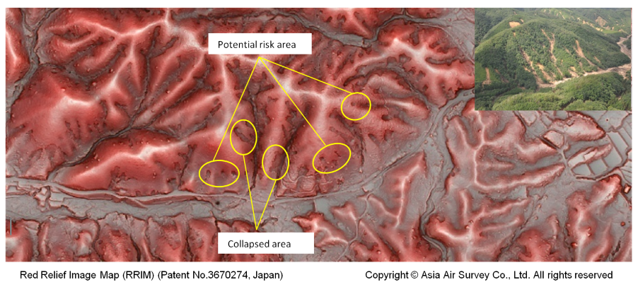
The terrain information beneath the tree is as important as the forest resource information as it enables us to know terrain features and potential risks.
To analyze and visualize topographic conditions in detail, a special visualized topology map Red Relief Image Map (RRIM) (https://www.rrim.jp/en/) was generated based on multi-layered topographic information computed from DEM.
The RRIM has overcame the shortness of traditional visualization methods, such as weakness for scaling, light direction dependence, necessity of stereoscope and filtering, it can express details of topography by using a single image map.
The Wrap
RRIM makes it possible to manage existing mountain restoration facilities, identify mountain disaster risk areas such as collapse and landslide, and formulate countermeasures. It is also effective for grasping cracks caused by earthquakes in forest areas. It can improve the forest Fieldwork efficiency by giving direct visual reference.


Great piece of work! Welcome to Canada and Good luck!
Hi Kei, Just read your article. Very interesting! The techniques are advanced. I would be interested in hearing more about what the three components of the Laser Forest Type Image are. I think the two most innovative companies in Canada for lidar forestry applications are Forsite Consultants in BC and Lim Geomatics in Ontario. Good luck, you have a lot to contribute! Fiona