


A List of Geospatial Open Data Resources in Canada
Recently, I read an article about the Canadian Geospatial Data Infrastructure (CGDI) that seeks to explain why the CGDI, among many things, is relevant. While the Canada Centre for Mapping and Earth Observation (CCMEO) who is in charge of the CGDI have updated it to reflect changes to the Government of Canada’s own Open Data infrastructure, the CCMEO only offers a small glimpse of what’s on offer for Geospatial Open Data in Canada.
Right now, there are few resources discussing the various open data offerings covering Canada. Of the few that exist many are either poorly engineered, out of date, or sometimes both. I’m providing a snapshot of open geospatial data resources covering Canada as 2016 comes to an end.
Let’s have a look at the existing open data aggregators, beginning with the national level.
Open Government Programs in Canada
This isn’t the first attempt at throwing all the data together in one location for all of Canada. First, the Government of Canada has offered a map that displays known open data programmes in Canada as part of their recent Federal Government web-page overhaul.
The map on the page is excellent at letting individuals know which parts of the country support Open Data, and it has a calendar for events. The downside is that both that it relies on user input, and the OpenLayers map prevents you from selecting communities which are adjacent to each other. Watch below as I fail to reach Surrey in the same time it takes another user to google “Open Data Surrey”.
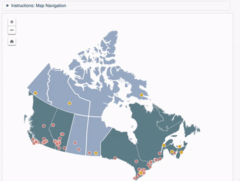
Figure above shows the limitations as far as you can zoom in…
Data Libre & Open Data Inception
- Data Libre – by Civic Access
- Open Data Inception – aggregated global open data
GeoGratis & GeoBase
GeoGratis – A maze of federal government data. Unlocking the ability to navigate through this site (or more recently, just using the geospatial extraction tool) unlocks all the basic data you need to start on that nice mapping project. Alternatively, learning the National Topographic System (NTS) and using this well-curated FTP site is an easy way to get the data you need. While GeoBase was once a shining star in the provision of Canadian geodata, their scope in purpose has become less clear since the federal government has pushed for data to be “open by default“, and GeoGratis has taken the reigns on hosting all geodata including what is included in GeoBase.
Open Canada Data – This is where the bulk of non-geospatial data generated by the federal government resides.
Province/Territory Level and Below
At this point, we should all know that Canada is but a federation of provinces that play their own game according to their own situation. As a result, there are provinces which are very open about their data (BC and Ontario), there are provinces that are using it to support both community and industry (Alberta), there are provinces that are starting (the maritime provinces), or holding off on open data altogether (Saskatchewan). Here’s a list of all the provinces and their data holdings:
British Columbia – DataBC
BC has an older system that processes its data. While some of the user interface may be difficult to understand at the start, they have a decent customer service team and dedicated individuals who are part of the community. In addition to the provincial government, many communities boast an open data portal as well as the only Aboriginal nation in Canada! The following is a list:
GTFS Feeds (General Transit Feed Specification)
Regions/Towns/Cities/Etc
A Reminder on Open Data on the Westcoast: Unlike other large cities, Victoria and Vancouver aren’t amalgamated. This means that the data which is covered in the city’s open data portal doesn’t cover the entire metropolitan area. If you plan to create studies for the entirety of Victoria or Vancouver, beware!
- Nanaimo
- Cowichan Valley
- North Cowichan
- Capital Regional District
- Victoria
- Saanich
- North Vancouver
- Qualicum Beach
- (Vancouver) Islands Trust
- Surrey
- Langley
- Chilliwack
- Metro Vancouver
- City of Vancouver
- New Westminister
- Richmond
- Regional District of Central Okanagan
- Regional District of Okanagan
- Regional District of North Okanagan
- Regional District of Okanagan-Similkameen
- District of Peachland
- Westbank First Nation
- Kamloops
- Kelowna
- Vernon
- Prince George
- Nelson
Alberta – [1] – [2] – [3]
Alberta, like BC, supports the distribution of open data for social issues as well as mapping, but also boast high-end datasets which includes some of the most precise digital elevation you could obtain for free in Canada! Unlike the rest of Canada, Alberta appears unique in using private industry to deal with open data through a partnership culminated in AltaLIS.
GTFS Feeds
Regions/Towns/Cities/Etc
- Red Deer
- Grande Prairie
- Grande Prairie County: [1] – [2]
- Edmonton
- Edmonton – Capital Region
- Calgary
- Medicine Hat
- Calgary Regional Partnership
- Airdrie
- Chestermere
- Banff
- Black Diamond
- Canmore
- Cochrane
- High River
- Irricana
- Nanton
- Okotoks
- Strathmore
- Turner Valley
- Redwood Meadows
- Lethbridge
- Strathcona
Saskatchewan
Saskatchewan contains open data resources provided by myriad provincial authorities, but it isn’t aggregated except at sites such as Open Data Saskatchewan, an advocacy which hasn’t updated its list within the last two years.
Regions/Towns/Cities/Etc
Manitoba – Data
There appears to be an open data site, but it hasn’t been updated since 2014. Not only is this a neglected resource, but it’s old and broken. To get to the data, you must first register. The registration process doesn’t verify your email address. Once you’re in, the browser warns you of a lack of a security certificate, and you won’t see any fancy web-design either. I’ve been told that the government is rebuilding their website, so there might be a big change in the data landscape for 2017.
A sample of what treasure awaits those brave enough to navigate the early-2000’s web design!
GTFS Feeds
Regions/Towns/Cities/Etc
Ontario – Data
Ontario has a well-developed open data catalogue and a strong community that promotes the use and critique of open data. The province holds most of its open geodata on their catalogue.
GTFS Feeds
Initiatives
Regions/Towns/Cities/Etc
- Toronto
- Ottawa
- Hamilton
- Guelph
- Thunder Bay
- London
- St Catharines
- Chatham-Kent
- Kitchener
- Brampton
- Huron County
- Haldimand County
- Kingston
- Sudbury
- Mississauga
- North Frontenac
- Windsor
- Burlington
- Waterloo
- Region of Waterloo
- Peel Region
- York Region
- Welland
- Oakville
- Grey County
- Niagara Falls
- Niagara Region
- Milton
Québec – Données
While not as strong as Ontario, Alberta or British Columbia’s open data sites, Québec has a strong offering, a growing culture and many towns which are growing their own data programmes.
GTFS Feeds
Régions/Villes/Etc
New Brunswick – Data
This past April, the Premier of New Brunswick pushed forward an “open by default” data policy (News Release). This means that while the open data site may not be as heavily-populated as other, richer provinces, it should continue to grow in 2017.
Regions/Cities/Etc
Nova Scotia – [1] – [2]
Nova Scotia also has a favourable attitude towards open data as a whole. And while “open by default” isn’t a law quite yet, their civil service aims to head in that direction as seen in their directives (pdf).
GTFS Feeds
Regions/Cities/Etc
Prince Edward Island – Data
Prince Edward Island provides open data since as early as 2001, when it had a civic addressing system which offers geographic data on the location of all its addresses. At the same time, NB embraced open data, PEI quietly went to an open-by-default and has also removed any licensing requirement before each download.
Address Data
Newfoundland and Labrador – Data
Newfoundland and Labrador also are new to the open data world. They’ve only been active for two years (press release) and spout a decent site, despite all the troubles that are ongoing in the eastern province.
Regions/Cities/Etc
Yukon Territory – Data
Regions/Cities/Etc
Northwest Territory
As of right now, there appears to be no territorial agency responsible for the dissemination of open data. In the intern, NT Geoscience has offered a large portion of their geological data and findings in support of the mining industry. Also, a small group of civic hackers collected some non-geospatial data and have assembled it here.
Regions/Cities/Etc
Nunavut
As of right now, there appears to be no collection of data for Nunavut in the open held by a provincial agency or below
All of Canada, from outside Canada or by the best of Canada
There are some stellar sources of data which exist outside of Canada with a global reach. I enjoy using this data and so can you!
- USGS Earth Explorer. Unlike the Canadian open data offerings, this service gives you access to the entire series of Landsat images from all the sensors starting with Landsat 4 including both individual captures and composite images. This has been my first go-to for Landsat imagery and digital elevation since I started to use GIS.
- Geofabrik. This is a site that allows you to download data from OpenStreetMap, the map which you can (and should!) edit.
- Remote Pixel by Vincent Sarago
- Transit Land. This is a community-based group that seeks to offer data for all metropolitan transit services in easily-consumed formats.
- Transitfeeds. This is another community-driven site that seeks to offer transit data across the world, but in GTFS format.
- Public Sector Digest’s 2016 rankings of open municipalities. It’s worth a read if open data is your thing in general.
The End?
This is just a snapshot of the data I was able to capture that exists at the end of 2016. There’s a good chance a lot of this data will no longer be at the link by the time you attempt to access it. Websites evolve, scopes evolve and so do agencies. If you feel like you want to carry the torch, you’re very welcome to pick up where I’ve stopped. This article was drafted on a Github Repo with a CC0 license and breaking this article apart is simple as forking the repository and making this into your own thing. I’d be happy for anyone to carry the torch, or just copy all my links into their own website or map. Alternatively, add your comments below and one of the GoGeomatics editors can update this list if I missed anything or you feel I’ve been unclear.
Thanks to all contributors!
Making lists is a long process. There were a few people who took their time and offered a few links, a few corrections or a few explanations. They are (in no particular order):
- _Mapperz_
- Andrew Pratt
- Vincent Sarago
- Dave MacLean
- Peter Rushforth
- Jonathan Murphy
- Florin-Daniel Cioloboc
- Ted Mackinnon
- Peter Rukavina


Thank you for providing this overview!
The formatting for the New Brunswick section needs to be fixed. New Brunswick looks like it is a region of Quebec with the current formatting.
The link for Peterborough refers to the UK city that offers open data.
Also, St. Catharines is spelled wrong. Please correct.
What a great effort to compile valuable information in one place! For New Brunswick, you should add a link to the GeoNB Data Catalogue available through Service New Brunswick . This has been up and running for awhile now.
Hi David and Bernie, thanks for pointing that out! The formatting has been fixed. Sharon, I’ve also shot out your suggestions as well!
have you ever been to the new brunswick open data site from snb? they are one of the oldest in the country (started in early 2000s-ish). they publish all data needed to create a detailed atlas of the province including forest cover information. just trying to say that i think your description of the new brunswick site does not do it justice.
Some of these “open data” sites have data that is available for download but be sure to check their license agreements before using the data as some of these agreements are quite restrictive and limit what you can do with the data.
Hey, that’s a fair point.
Also, I keep this list updated around here: https://github.com/brianbancroft/OpenCanadaGeoData
These open data resources will be quite handy for me. As you may know, I am in the middle of writing a research paper about Canada right now, and all this data will be useful for me. Thanks for sharing it here.