GIS Program Langara CS

The Langara GIS program writes a monthly series on topics related to Open Source GIS for Everyone, by Rick Davidson and Jim O’Leary, Continuing Studies (CS) instructors at Langara College in Vancouver, B.C. This column will focus on QGIS and other Free and Open Source GIS Software, especially as it is used in Langara’s Geographic Information Systems CS Certificate program.

Articles by GIS Program Langara CS

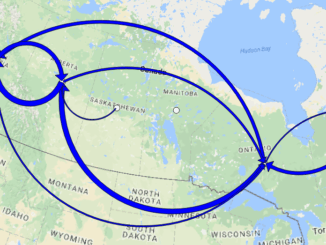
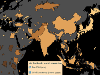
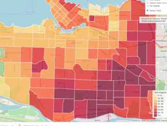
Leaflet: Tell Your Story with Open Source Web Maps

Web maps are becoming a standard tool that GIS developers use to tell their story to a worldwide audience. The…

Using Swipe Maps to View Wildfire Destruction in BC

On July 7, 2017 a series of devastating wildfires began in the Cariboo region of British Columbia. The effects of…

Two way arrows

Mapping Migration Flows with QGIS FlowMapper Plugin

Flow mapping is a technique to visualize movement of objects of interest between geographic areas. Typical uses of flow maps…

QGIS: Performing Viewshed Analysis on Archaeological Sites

In 1927 a Vancouver bylaw was enacted that limited the height of buildings to a maximum of six stories in…

The Integrated Cadastral Information (ICI) Society and ParcelMap BC

This is the first of two articles on the release of ParcelMap BC Data, which we see as a significant…

QGIS & WorldClim: Using Zonal Statistics to Map Temperature Patterns

There has never been a time in the history of GIS when so much free, high quality data has been…

Using Colour Transparency to Map Election Results

As the 2016 United States presidential election careens towards its conclusion in November, GIS plays a prominent role in both planning…

Making a Crow Attack Web Page With Open Source GIS Tools

Of all the pleasant events that happen in spring, crow attacks rank at the bottom of the pile. Crows become…

Georeferencing Scanned Maps Using QGIS

One of the passions of modern day information technologists is to convert the past to digital form and to put…

Vancouver: Using QGIS TimeManager for Analysis of Crime Data

We typically think of a GIS as features on a map with a maximum of three dimensions: Longitude Latitude Height…

Open Data, Open Source, Open Possibilities

Back in 2006 I (Jim) was a student at BCIT and a Vancouver resident, eager to obtain some local data…

Getting to First Base with GIS

A friend of mine who volunteers with a girls’ softball team came to me with a request recently. “I have…