


Canada Day Came Early at the Canada Aviation and Space Museum
June 23rd marked a special day in the history of aviation and space in Canada. A very special aircraft, a Convair-580, with its advanced Synthetic Aperture Radar (SAR) sensors, made its final flight after setting records and breaking down barriers both political and scientific for several decades. The former Canada Centre for Remote Sensing (CCRS) CV-580 completed its last flight on Tuesday June 23, 2015, and will be part of the collection at the Canadian Aviation and Space Museum (CASM) at the Rockcliffe Airport in Ottawa. This aircraft served the radar remote sensing research community since 1974 when it was purchased by CCRS. It was operated by CCRS until 1996, then by Environment Canada until 2014, and finally by the National Research Council (NRC) before the transfer to CASM.
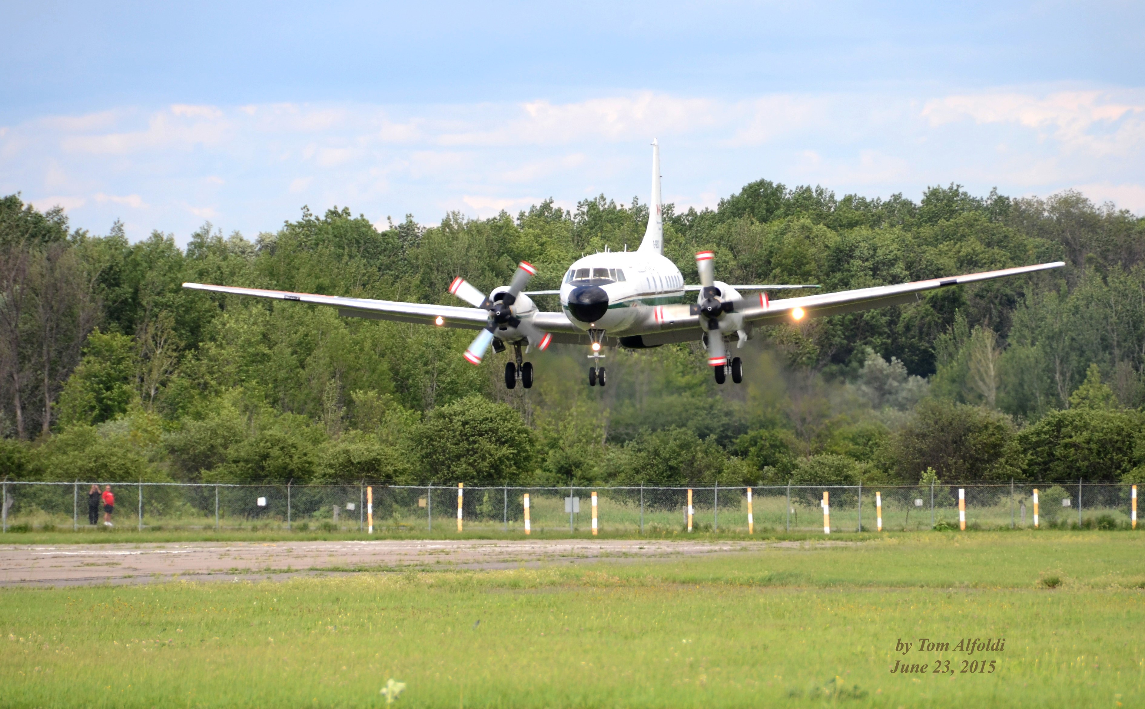
The flight by NRC pilots Paul Kissmann, Anthony Brown, and veteran engineer Theo van Westerop was under gusty and overcast conditions with a strong wind up the runway to assist with the shorter-than-normal runway at Rockcliffe. There was an appreciative crowd which included former technicians, scientists, and senior managers to greet the aircraft on this happy occasion. The aircraft first made a low overpass, then circled around for the landing. The photograph of the near perfect touchdown below was taken by Tom Alfoldi, one of the original CCRS Applications Division Scientists.
The landing came almost two years after museum curators first visited the Environment Canada Hangar to look over the system. Their determination to see the system enter its rightful place in Canada’s showcase for aviation and space was understandable: the system not only crossed over between aviation and space, it did so with great success at home as well as on the international stage. The linkage to space was obvious – the system provided the research behind Canada’s RADARSAT series of satellites, as well as several other satellites launched by the European Space Agency. It was not simply the aircraft or the all-weather imaging radar that was of interest: it was the whole package, a flying radar laboratory that was the best in the world in its time.
The system was not just a success in research. It is an example of Canadian innovation and technological excellence that has led to great success in the export market, as well as providing the proof-of-concept for several billions of dollars of investment by Europe and Canada in radar remote sensing satellite systems. What is perhaps not as well-known is the international imprint of this aircraft and sensors on board. In the 1990s it was the first foreign sensor/camera equipped aircraft allowed to acquire data over China since 1949. Furthermore, it was the first western aircraft to acquire such imagery over Vietnam since the conflict ended in that country.
Unlike others at the time, we in Canada used aircraft to prove and develop concepts before launching spaceborne systems – a cautious but effective Canadian approach. This flying laboratory is thus a symbol of how we approach scientific research: cautiously and in support of our economic, environmental, and foreign policy goals. The aircraft and the systems on board were also used to provide SAR imagery, share our experience, and demonstrate our excellence in Asia, Africa, the Middle East, Latin and South America, and of course, Europe. In many ways one may regard MDA as a creature born in part from its success.
Ultimately the system and its success were the result of collaboration between managers, scientists, engineers, and technicians in government, industry and academe who came together to build the system and use its data to establish its well-deserved reputation. It is unfortunate that a number of those responsible for its success are no longer with us; their names were certainly spoken and their accomplishments remembered by those of us who were there on June 23rd. We also owe our thanks to Environment Canada and the Department of National Defence which operated and supported the system most recently, the National Research Council, and the Canadian Aviation and Space Museum, as well as the volunteers who cooperated to make the final step happen. In the coming years we expect that there will be a significant volunteer effort to ready the system for display so all Canadians can see yet another example of Canadian excellence in science, engineering, and its application for the benefit of us all.
Detailed below are just a few of the wonderful accomplishments that came from this aircraft and its on-board equipment and data handling systems:
- It was the test platform for the billions of dollars already spent or committed to Canadian satellite systems that are now (and will in the future) protecting our sovereignty, our environment, and our way of life;
- It was the test platform for Europe’s early radar satellites (particularly ERS-1 and 2), and strongly influenced the development of national airborne radar test beds that are still being built and used in Europe and elsewhere;
- The technology developed helped MDA become a world-class provider of technology and data;
- Under Environment Canada research and development continued that supported RADARSAT-2’s advanced capabilities in polarimetry and along track interferometry, and led to the addition of the Moving Target Indicator modes of RS-2 funded by DND;
- Many other companies such as Intermap, PCI Geomatics, and others providing worldwide services and technology have been successful as a result of the system;
- The system has directly led to some of the worldwide success of our mining industry through improving exploration. This gave our industry an early “leg up”;
- In the first two decades of service, the system spanned the gamut of emerging and complex all-weather SAR imaging technology including high resolution, multi-frequency, multi-polarization, polarimetry, and along and cross-track interferometry;
- The technology was used to test and develop methods to predict landslides and subsidence associated with oil exploration and pipelines as well as applications dealing with ocean waves, surface wind speeds and directions, and moving target characterization;
- The systems associated with the Convair have allowed us to better understand ice and how to accurately map it to protect Canadians and our environment;
- The fact that we were trusted by China to be the first to be approved to operate a sensor-equipped aircraft over China is an important statement about us as a nation;
- The aircraft has flown as an ambassador for Canadian expertise in the science of remote sensing in more than twenty-five countries including China, Vietnam, Thailand, Malaysia, Taiwan, Jordan, Tunisia, Morocco, Kenya, Uganda, Germany, UK, Norway, Sweden, Brazil, Guyana, Costa Rica and USA; and lastly
- The net economic benefit of the system reaches into the billions of dollars including the ongoing employment of thousands of Canadians in well-paying and rewarding careers.
Dr. Bob Ryerson is a former scientist at CCRS and was Deputy Program Manager of the first GlobeSAR Program that saw the system fly in Asia, the Middle East and Africa. He would like to thank Bob Hawkins, Chuck Livingstone, and Tom Lukowski for assisting in the preparation of this manuscript and Tom Alfoldi, his former colleague of more than twenty years, for the photo.


What a brilliant commemoration you have bestowed on this Convair 580 aircraft, Dr Bob Ryerson, along with your remote sensing colleagues! Several times in the aircraft’s early years I was comforted to know SAR data was being ably collected while I collected ground truth data. This aircraft and its stories should make for exhilarating visits by scientists the world over.
A real piece of Canadian geomatics history. We owe a lot to that plane and the people that worked with it. Great article getting a lot of good social media attention at home and abroad. Thanks for sharing this story of innovation and inspiration with us.