
Fall 2021
LIDAR ACQUISITIONS 2021
The 2021 LiDAR acquisition period is already coming to an end. In addition to integrating data from several organizations across the country, the Canada Centre for Mapping and Earth Observation (CCMEO) team is managing 3 major contracts this year funded by the Emergency Management Strategy for Canada. This new data will be integrated to existing products and will be useful for several analyses, including those related to flood mapping. Here is a summary of the LiDAR acquisition projects that are being implemented by CCMEO in 2021:
A first project is located over the Hamilton, St. Catharines, Welland and Niagara region in Ontario. This 2,982 km2 region was selected with representatives from the province of Ontario. It is particularly interesting because it covers four of the 100 largest Canadian cities, it is transboundary with the United States, and it will provide data continuity with other existing LiDAR data in southern Ontario.
The second project underway is over the Last Mountain Lake region in Saskatchewan. The project area covers 4,064 km2 and was selected in collaboration with representatives of the Saskatchewan Water Security Agency and the George Gordon First Nation. It includes 13 identified flood-prone municipalities previously identified by the Province.
Finally, Natural Resources Canada (NRCan), with the Saskatchewan Water Security Agency, is carrying out a first topo-bathymetric LiDAR data acquisition contract for South Saskatchewan River area, covering over 517 km2. In addition to testing the Federal Airborne LiDAR Data Acquisition Guideline, this contract will help evaluate the effectiveness of topo-bathymetric data collection over the Prairies and help assess the cost-benefit of topo-bathymetric LiDAR compared to other technologies, such as Sonar, for flood mapping. While this technology has clear advantages, it still presents challenges in Canada, depending on location, water clarity, and weather.
NEW PRODUCTS AND ELEVATION DATA
High-Resolution Digital Elevation Model Mosaic
Last winter, NRCan announced the release of the High-Resolution Digital Elevation Model Mosaic product (HRDEM Mosaic). The HRDEM Mosaic product was developed for users to visualize and interact with the data produced under the strategy. Unlike the HRDEM product in the same series, where data is separated and distributed by each acquisition project, the mosaic is created to provide a single, continuous representation of data from the Strategy. The most recent datasets for a given area are used to generate the mosaic. The coverage of the HRDEM Mosaic product will gradually increase as new HRDEM data becomes available.
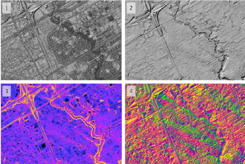
A new feature this fall is the creation of a visualization tool for the HRDEM Mosaic product. This new web application allows a simplified and quick access to all the derived products offered in the product. A new and efficient way to visualize the most accurate elevation data in the country!
The HRDEM mosaic is distributed through the Data Cube Platform implemented by NRCan. This platform is a powerful and scalable system based on open technologies and implemented in a cloud-computing environment. The objective of the platform is to make large geospatial datasets and time series accessible to decision-makers, stakeholders, and the public through standardized web services. These technologies for managing and exploiting geospatial big data enable fast and efficient access and visualization of high-resolution geospatial data and generating on-the-fly derived products.
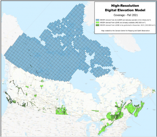
New elevation data derived from LiDAR
With the collaboration of several partners, NRCan continues its work to provide Canadians with new, accurate and up-to-date LiDAR-derived data across Canada. Last June, an additional 107,000 km2 of coverage was added to the HRDEM and HRDEM Mosaic products. The data was distributed over 8 provinces: British Columbia, Alberta, Saskatchewan, Manitoba, Ontario, Quebec, Nova Scotia, and Newfoundland and Labrador.
This fall, more than 100,000 km2 are added to the products, with additions in British Columbia, Manitoba, Quebec, Prince Edward Island, and the Northwest Territories. With the release of this fall, the total coverage of LiDAR-derived elevation data integrated into the National Elevation Data Strategy is now nearly 600,000 km2, covering 84 of Canada’s 100 largest cities!
IMPROVEMENTS OF THE AUTOMATIC EXTRACTION OF BUILDING FOOTPRINTS
Since its creation in 2018, the Automatically Extracted Buildings product continues to evolve. Building footprints from over 60 LiDAR acquisition projects throughout Canada are now distributed free of charge online through the Government of Canada Open Maps portal. Product coverage will continue to grow in the coming years!
The Auto-building system automatically extracts building footprints from airborne LiDAR datasets without any manual corrections. When the “building” class is present in the LiDAR data, about 95% of the buildings are detected, while 80% of them have a good geometric representation. This makes it an interesting product for the detection of buildings in areas with natural hazards, as well as a valuable baseline input for the creation of a more elaborate building layer. The minimum and maximum height and elevation attributes associated with each building can also serve as basic information for various exploratory analyses.
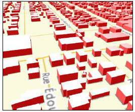
Over the course of the last few months, particular effort has been made to improve the automatic building extraction system. The performance of the system as well as its ability to handle massive data sets have been greatly improved. In addition, a study aimed at determining the impact of several LiDAR acquisition parameters on the quality of the building footprints generated by the system has recently been conducted. These parameters include point cloud density, the presence of leaves in trees, the type of landscape (urban versus rural), and the amount of overlap between swaths. The results of this work will allow us to optimize the parameters of future LiDAR acquisitions, and better understand the limitations associated with the extraction of buildings using older LiDAR datasets whose acquisition parameters are often highly variable.
VALIDATION OF LIDAR CLASSIFICATION BY ARTIFICIAL INTELLIGENCE
CCMEO’s Innovation and Artificial Intelligence team, in collaboration with the University of Sherbrooke and the Computer Research Institute of Montréal (CRIM), conducted research to facilitate the use of automatic algorithms for the classification of LiDAR data. This research identified a methodology to apply on different datasets included in the National elevation data strategy and tested its efficiency. The methodology and the results were published in the special edition “Large-Scale Deep Learning for Sensor-Driven Mapping” of the Canadian Journal of Remote Sensing in May 2021. The publication, entitled “Large-Scale Classification of Airborne LiDAR Point Clouds by Deep Learning”, is available in English only.
A second paper that focuses on improving the methodology will also be submitted to the Canadian Journal of Remote Sensing in the fall of 2021. The research will be published on the Savoir UdeS portal, under the title “Automatic classification of point clouds from airborne LiDAR by continuous convolution network” [http://hdl.handle.net/11143/18699] (document written in French, with the articles in English).
This research developed expertise and enabled the use of these algorithms in the data validation process. LiDAR classification validation is a process that requires significant manual intervention and is therefore only performed on a small portion of the dataset. By comparing the automatic classification by artificial intelligence and the one performed by the contractor, it is now possible to validate all the project LiDAR data and target the areas where manual interventions are necessary. This reduces the manual effort to validate the classification of points and increases the process robustness. This new innovative approach is a potential major step forward for more standardized LiDAR classification in the country.
We need your feedback!
Do not hesitate to provide us with comments and concrete examples of how you use the data. This helps us to stay relevant and demonstrate the importance of the strategy. You can email us at:
The authors of the articles are:
David Bélanger
Guillaume Légaré-Couture
Charles Papasodoro
Mathieu Turgeon-Pelchat
Pierre Tardif


Be the first to comment