
- Digital Twins and the Ontario Housing Issue
- Benefits of BIM and Geospatial Technology Integration Into Construction Supply Chains
- ESRI Introduces ArcGIS Reality
- The Key for Canada’s Housing Crisis? Digital Twins
- Is Digital Twin Technology As Good As Metaverse?
Digital Twins and the Ontario Housing Issue
Using Digital Twins technology properly will change the housing game in Ontario.
Digitizing and standardizing the development approval process will speed up new home construction. Digital Twins can increase productivity, mapping transportation and road networks, as well as building better infrastructure and homes.
Canada is decades behind other countries when it comes to digitalization. We are 34th out of 35 Organization for Economic Co-operation and Development countries for the length of time it takes to secure approval for general construction projects. Canada is also ranked 64th out of 190 countries in terms of construction permitting.

It takes too long to get housing project approvals in the GTA. In a 2022 study by Altus Group, it showed the process took 32 months for approval.
There are benefits of Digital Twins for this issue. A virtual replica of a building can be made by the design community that would help studies in behaviour and building interaction when there are changes.
Digital Twins can also improve growth planning by addressing needs of infrastructure and housing, helping planners and designers to make improvements quickly. Digital Twins can address environmental, economic, and social challenges.
Currently, AECO Innovation Lab and four universities are partnering to study Digital Twin Technology and its effects on investments, predict needs, develop sustainability, and help operations.
Digital Twins are up for the challenge.
Benefits of BIM and Geospatial Technology Integration Into Construction Supply Chains
Integrating BIM and Geospatial Technology can solve many construction site and supply chain issues.
As BIM and Geospatial technology become integrated into the construction industry, more immersive solutions will be created. Digital plans can be reviewed, edited, simulated, and scheduled in real time, avoiding delays.
BIM can assist architects, engineers, and contractors from the very beginning of their projects. They can get more accurate estimates, variables can be taken into account, as well as weather damage, security, and human error. 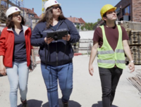
You can have real-time data supply costs and availability, and use BIM technology to create a safer workplace with its “Clash Detection” feature. The feature identifies risks before situations can happen. Other benefits from using BIM and Geospatial technology include eliminating rework, improved communication and easier project take over.
Geospatial technology can help the construction sector by monitoring supply chains, scheduling orders, supply chain mapping, and inventory management.
It is only a matter of time before both technologies become mainstays at construction sites.
ESRI Introduces ArcGIS Reality
ArcGIS Reality is a reality capture extension to ESRI’s flagship GIS platform.
ArcGIS Reality layers 3D data, BIM, and GIS information, allowing analysis, asset monitoring, and predictive simulation. The ArcGIS application already handles large data sets and information.
ESRI believes mixing BIM, the ArcGIS platform, and reality capture models, when connected to real-time sensor feeds, will form a type of Digital Twin. Part of ESRI’s focus was to make 3D models a part of the ArcGIS platform.
To become a Digital Twin, a model must be connected to a live sensor. A 3D model alone has no intelligent information, which is one needed step in becoming a Digital Twin. ESRI is already working on this. The company is combining 3D captured data with a range of 2D GIS.
The world of reality modeling is continually growing. Different firms are taking different approaches and this is good.
Currently, the cost of a one-year subscription for ArcGIS Realty Suite is 20k.
The Key for Canada’s Housing Crisis? Digital Twins
The Digital Twin market is growing. It has recently been predicted to reach $48 Billion by 2026.
Automotive, health care, systems engineering, and aerospace industries are all using Digital Twin technology, and there are cities all over the world using Digital Twins technology to create smart cities.
Digital Twins could be the tool to use when it comes to handling the housing supply crisis. It allows engineers, architects, and developers to test changes that could speed up or improve a new build. They can also see the outcomes of those changes quickly.

Digital Twins are moving from simply being highly specific applications to management best practices. This technology can improve growth planning on a macro scale, used to address community housing and infrastructure needs, and transportation models. Los Angeles uses Digital Twins to make model transportation movement so mobility infrastructure can be improved. Stakeholders can run scenarios to improve structure and balance labour costs.
AECO Innovation Lab is working together with four Canadian universities on a $1.32-million One Ontario project to explore technical challenges that regulatory agencies must resolve to accommodate the creation of digital twins.
Is Digital Twin Technology As Good As Metaverse?
The difference between Metaverse and Digital Twin Technology is Metaverse was developed to escape the real world, and Digital Twins were developed to make the real world better.
Metaverse is a vision for the future of human culture. It deals with what the public and product companies would do with certain technology such as virtual worlds and spaces.
Navigating virtual spaces and creating virtual objects in the real world, requires the most advanced version of this technology, for both Metaverse and Digital Twins.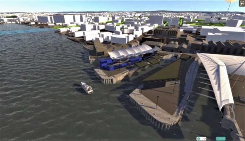
Simply put, a Digital Twin is a virtual replica of an existing physical object, infrastructure, or system. Today, Digital Twins are still developing, in need of better AI, sensors and tools
Today, Companies are using Digital Twins technology for testing, integration, testing, simulation,monitoring, and predictive maintenance on bridges, buildings, wind farms, aircraft and factories. It is still early for these Digital Twins.
It’s time to use virtual spaces to improve the world around us.


Be the first to comment