
In the middle of March 2020, COVID-19 pandemic leads to social distancing rules in Canada. Public areas such as restaurants are closed. Some restaurants in Kamloops city in British Columbia have been working through takeout or delivery ordering options. Kamloops residents wanted to know the updated information about their favourite restaurants and how they could order food and drinks.
The inspirational story behind the story map creation
After almost two weeks of this pandemic in Canada, Two Story Robot took the initiative and created a directory of local food and drink establishments in Kamloops, providing the updated information of each restaurant. They asked residents to send the receipts of their food and drink orders from locally owned businesses to match what residents spent in a donation to the Kamloops Food Bank.
This initiative for supporting Kamloops local businesses was truly inspiring. As a GIS person, I thought it would be easier for people to navigate and find their favourite restaurants on the map along with up-to-date information. I used this data directory to create an Esri Story Map . Check it out! (Click the image below to view the story map)
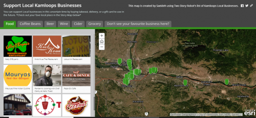
How does this story map work?
The Story Map is simple to use. There are several tabs at the top of the map which show food and drink categories. For ordering food, you can click on the “Food” tab which represents local restaurants in Kamloops. Your favourite restaurant can be found by searching its logo or picture on the left side of the story map or its location on the map on the right side.
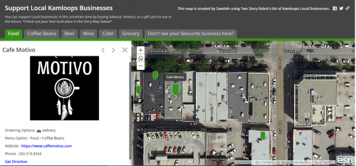
Your proffered restaurant’s location and ordering information will appear on the story map along with “Get Direction” on Google Maps.
Local restaurants are gradually reopening, however, takeout or delivery services are still so popular. People in Kamloops can use this story map to find their favourite restaurant quickly, and continue to enjoy their food and drinks while support local businesses.


Be the first to comment