GoGeomatics: Welcome to the GoGeomatics Canada community. To get started can you tell us about where you are from and why you decided to make a career of GIS?
Darin Brooks: Thanks for having me contribute to your magazine, Jon. It’s an honour.
I was born and raised in Saskatchewan and completed both of my undergraduate honours degrees in Saskatchewan. I moved to British Columbia right after university and stayed for about ten years. I began my Master’s degree in BC before leaving for the Promised Land (Newfoundland) in 2009.
Why did I make a career of GIS? I don’t think there is a discipline that has as many flavours as GIS. GIS is really the people behind the programming, analysis, planning, cartography, databases, points, lines, and polygons. And because GIS has become ubiquitous in today’s world, the fraternity that makes up GIS analysts is nothing short of fascinating. Analysts have such varied backgrounds and bring such knowledge and richness to projects. GIS is the glue that binds those who need information … to those who collect information … to those who make sense of the information … to those who use information … to those who use the information to drive decision-making. It’s the great equalizer. GIS provides a way for all those involved in a problem to participate as a stakeholder and be part of the solution, whether their contribution is input, throughput or output. How can you not love a career that offers you that?
GoGeomatics: Where did you get your geomatics education?
Darin Brooks: I started my education at the University of Saskatchewan and University of Northern British Columbia. But to be perfectly honest, my education isn’t finished. GIS is a discipline that requires a lifetime of commitment to education. Lifelong learning. Technology and applications move forward and change so quickly. My continuing education comes from my mentors, my colleagues, and my students. They all have something to teach me about the applications of GIS. I suspect my geomatics education will end the day after I retire.
GoGeomatics: What was your first job in geomatics?
Darin Brooks: During the February reading break of my last year of university, I accepted the position to start a remote sensing department in a small forestry firm in Prince George, BC. I was very fortunate to have a job waiting for me after convocation – particularly in my field of study. GPS and GIS were starting to hit their stride in the day-to-day operations of forestry in central BC, and remote sensing (non-air photo) was still in its infancy. It was an exciting time to break into the “biz” and I am very thankful for the early opportunities that were afforded to me.
GoGeomatics: How would you describe you geomatics career so far? Can you tell us how you got to be where you are now as GIS instructor in Newfoundland?
Darin Brooks: It’s never been boring. I have had the good fortune to work with progressive firms who have always embraced new technology. This allowed me to be involved with operational research projects that took GIS and remote sensing to the cutting edge. I was also very fortunate to work with firms that emphasized multi and interdisciplinary skills. So I’ve been involved in the data collection, organization, analysis, and reporting.
It helps an analyst appreciate where the data came from … and where it’s going. I interviewed for the position over the phone and accepted the job without ever leaving British Columbia. I just knew that CNA was the right fit for me. The program was brand new and had solid support from the college administration and the Geospatial Research Facility (an on-site multi-million dollar research initiative that uses the most modern mapping, sensing and data collection techniques.)
GoGeomatics: Can you tell us a little about the history of the GIS program at your school?
Darin Brooks: The program wouldn’t be here without the tireless commitment of many that came before me. Several members of the Geospatial Research Facility and the Dean of Natural Resources at CNA were instrumental in program design and implementation. The evolution of the program began with the Centre for Forest and Environmental Studies, to encourage hybrid-style programs (where students have the opportunity to add a GIS competency to their primary training). Of course, the government of Newfoundland and Labrador was an extremely important partner in this timely venture, as it provided the necessary funding to create and equip a first-class GIS lab facility. The government also provided funding required in hiring faculty and program sustainability. We had our first intake of students in 2009/10 and have been steadily filling the seats since then.
GoGeomatics: What makes an excellent GIS program? How do you, as a GIS instructor, make sure that what your teaching and imparting to new GIS students is giving them the skills and the problem solving they will need for the work force?
Darin Brooks: In my opinion, an excellent GIS program is contemporary with its software/hardware, but is also contemporary with its knowledge. It incorporates current industry needs into the curriculum. By having students design GIS solutions for current real-world problems, we are providing them with a confidence that is immeasurable. I ensure that students have as many opportunities as possible to sit in on industry planning sessions. They get to see the whole discussion between those who need the data and those who can provide it. My students get to experience what it means to be starting from scratch LONG before they hit the bad old world. It sharpens their people skills and helps them become better communicators.
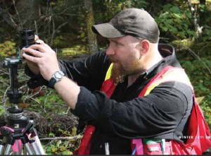
It’s impossible to be a good GIS analyst in industry without ever putting some time in the field. GIS is about modeling the real world. It’s difficult for a person who lives among models to have the perspective of the real world without seeing the real world. Understanding the inputs that feed our analysis/models empowers us as analysts. I have several projects and assignments (including their major GIS project) that involves the students leaving the lab and going out to gather their own data.
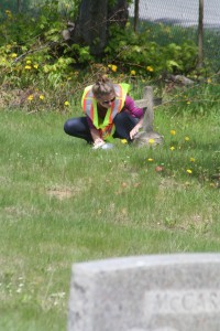 In fact, the students of the 2011/12 class leveraged a hands-on class project into a small research grant:http://www.cbc.ca/news/canada/newfoundland-labrador/story/2012/07/06/nl-graveyard-mapping.html.
I try my best to provide students with real-world examples with real-world data that relate to them personally. It’s not uncommon that I write 5 to 10 different scenarios for the same assignment. When the student has buy-in into a particular project or problem they tend to sink their teeth into it. As an instructor, you just have to be aware of every student’s background and find the right switch to flip.
An excellent GIS program also puts the right amount of weight on both theory and practical to find the balance. A student can’t design a proper geodatabase with logical relationship classes without understanding the importance of database theory. On the flip side, understanding the concepts of spatial analysis is hollow if you can’t run the analysis and create a resultant dataset that is accurate and useful. We take the students well beyond introductory concepts and applications. Our students are taught to use the power of ArcGIS and ArcCatalog beyond that of a technician. We take them to a higher level of analyst where they gain competencies in sophisticated project design, analysis and implementation.
We also find that an excellent GIS program provides the students with an opportunity to implement what they have learned through a major project or thesis. CNA GIS students start working on their major GIS project from day one. They are asked to create a project proposal by the end of the first term. We find that by the time the intersession term arrives, they have had 7 months to make connections between their major GIS project and their class work, labs, and assignments. They are ready to implement what they have learned and apply their knowledge and skills to their project.
Finally, we put a heavy focus on project planning and design. Students are required to plan all their GIS projects (from the smallest lab to the largest assignment) on paper and pencil (or Visio) before they touch ArcGIS. They are required to conduct thorough data inventories and recognize what data they have … what data they are missing … and what data they need to create. The students are expected to develop geodatabase schemas for every project to ensure feature datasets, subtypes, domains, relationship classes, topology, and networks are planned. We emphasize the importance of a well-planned and well-designed project. Many of our graduated students comment that this is the skill that they are most thankful for.
GoGeomatics: In terms of GIS concepts what is the most difficult item to teach?
Darin Brooks: Generally speaking, the programming and database concepts can be the most difficult to teach. Functionalities such as ESRI ModelBuilder have empowered the new breed of analysts to “program” without having to learn the formal languages (such as PYTHON). It’s not that they can’t learn to program, as many find out that using PYTHON opens a whole new world them. It’s the stigma that goes with programming. Once they embrace the notion that they CAN program, the concepts fall into place. And consequently, the students become more efficient analysts. The same goes for database competencies. Looking at a flat file of data or several data sources is sometimes overwhelming, especially when you are asked to link these data sources together somehow. Normalization of tables and data, like programming, has its own stigma. Every now and then we get a student who can normalize data on-the-fly. But generally, most students will go through the feeling of frustration when it comes to normalizing data. Again the good news is that this skill isn’t genetic. Practice and encouragement go a long way.
GoGeomatics: What are you looking for in a prospective GIS student?
Darin Brooks: An aptitude for computers doesn’t hurt. But the real strength in a GIS student lies in their ability to see how GIS fits into their discipline. They need to have a natural curiousity that keeps them asking: “How can I better understand my data? Are there patterns to my data? Where are those patterns? Why do the patterns exist?” Our program is post-diploma, which means students must have at least a two-year diploma or 4 year degree to be accepted into the program. For the most part, our students have already started to pursue a career in a particular field or discipline. They come to us to add GIS as another tool to their toolbox. If they can make the link between their discipline and how GIS can be used to improve their decision-making or predictive modeling, then it’s easier to help them see the details. If we have to convince them that GIS could be useful to them, then even the more general overarching concepts tend to be more difficult to explain. We try our best not to miss opportunities to admit students who have the more non-traditional GIS academic backgrounds. Our students have majors in: business, forestry, fish and wildlife, psychology, criminology, environmental studies, history, geology, geography, and drafting.
GoGeomatics: Do you have any student portfolios that you would like to share with us? Some that might give other potential students an idea of what to expect if they were to come to work with you?
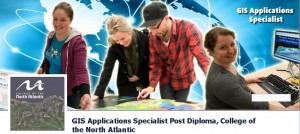
Darin Brooks: I would encourage people to visit our Facebook page (GIS Applications Specialist Post Diploma, College of the North Atlantic), College web page (http://www.cna.nl.ca/programs-courses/School-Tourism-Natural-Resources.asp), LinkedIn page: GIS Applications Specialist Program (Post Diploma), and soon to be launched GIS program webpage for more details on student led projects and program details.
GoGeomatics: What makes the GIS program at CNA stand out from all the other programs out there?
Darin Brooks: I’d like to think it’s our dedication to the science and the experience/attention our students receive. The college administration shows their commitment to the program by providing the instructors with every opportunity for professional and personal development. The CNA Office of Applied Research provides opportunities for faculty and students to participate in cutting edge research. Several of our student major GIS projects have directly contributed solutions to actual industry problems:
Ambulance Project http://www.thewesternstar.com/News/Local/2011-09-12/article-2745594/Project-could-influence-ambulance-policy/1
St Anthony Asset Mapping http://www.northernpen.ca/News/2012-04-03/article-2943298/Theres-a-map-for-that%0D%0A/1
CNA GIS Students(2009) http://www.thewesternstar.com/Arts-Life/Education/2010-07-03/article-1567049/Student-projects-finding-applications-in-the-real-world/1
The respect and support from the college administration creates a culture of enjoying the workplace and wanting to come to work. This positive experience rubs off on our students, as they see the zeal that we have for teaching and learning GIS. It gives the students permission to have zeal too. Our instructors and instructional assistants are very well-trained and have a considerable amount of real-world consulting industry experience. It gives us the ability to teach the students what they will need to know once they graduate. We are also very fortunate to have a strong alliance with the Geospatial Research Facility at the college of the North Atlantic. Research at the Geospatial Research Facility involves a wide variety of industry sectors that serve Newfoundland and the Atlantic region, including: mobile solutions, geovisualization, ecological modeling, terrain analysis, and web-based GIS solutions. Our students have access to the expertise that GRF houses.
I would also attribute some of the program success to the academic ties within our Natural Resources department here at College of the North Atlantic. We have strong environmental technology, forestry technician, and fish & wildlife technician programs that serve as natural collaborators and program feeders. We also have a nice working relationship with our Civil Engineering Program. GIS Students have access to real-world expert advice and expertise within the building. This provides the potential for collaborative projects or research.
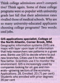 In 2011, Maclean’s magazine targeted our program as one of the hottest post-grad programs in the country:
The College Advantage http://oncampus.macleans.ca/education/2011/03/02/the-college-advantage/
Here’s what some of our students and major GIS project sponsors have to say about the program:
“While I value my previous years of post secondary education, it was not until this program that I could unequivocally say that I had finally made the right decision when it came to a career path. I now feel fully prepared to approach the workforce head-on with confidence, armed with an invaluable, tangible skill set. Learning has become fun and thanks to dedicated, knowledgeable instructors, universally important concepts have been mastered and are now being applied through a major GIS project, linking us to industry sponsors and supporting relevant social, economic, and environmental needs.”
Andrea Dort, BSc (Biology), MSc (Environmental Applied Science), CNA GIS student, 2011
“My time spent in the GIS Analyst post-diploma program at College of the North Atlantic in Corner Brook was possibly some of the most useful of my entire time spent in post-secondary education. Overall, my experience at the post-diploma GIS program at CNA was invaluable. I tell everyone that I can about this program and what it has done for me as it deserves all of the praise and recognition that it receives. I can only hope that it benefits other upcoming GIS Analysts the way that it has helped me.”
Madison Muggridge, B.A (geog), Geospatial Technologist at Government of Newfoundland and Labrador CNA GIS graduate 2010
” … It has been a pleasure working with CNA instructors and students on their GIS projects. The CNA program is a great opportunity for students to grapple with a real world data set. It forces them to do the creative thinking required to solve real world problems. For us, it provides a useful pilot study and novel analyses that provide new insight. We hope to continue working with the CNA – GIS Applications Specialist Program in the coming years.”
Keith P. Lewis, Senior Scientist, Dept. of Environment and Conservation, Sustainable Development & Strategic Science Branch
“I could not have been happier of my choice of program. This program gave me all the tools required to succeed. We learned to develop strategies to successfully implement GIS projects in an autonomous and practical way. Scientific and statistical thinking were stressed throughout the training. Upon graduation I quickly received employment in my new field without any prior work experience. I’m currently delivering training on how to use the Python programming language to automate Geoprocessing applications.”
Pierre Garigue, BEng, GIS Consultant at Integrated-Informatics CNA GIS graduate, 2010
“Our experience with the CNA GIS Applications Specialist Program was very positive. The instructors and students were professional and very knowledgeable. The results of the student major GIS project exposed an issue with patient transport which Western Health was totally unaware. Consequently, the issue was addressed.”
David Buckle, Western Health, Regional Director Paramedicine & Medical Transport
“The CNA GIS Analyst program is highly a comprehensive program with incredibly knowledgeable and dedicated teachers. The Major GIS Project is an excellent opportunity to gain real world experience and contacts”
Kristen Scott, B.A. (psyc), CNA GIS student, 2011
GoGeomatics: What are the job prospects like out there for graduates of your program?
Darin Brooks: The job prospects are amazing. There really isn’t an industry out there that doesn’t benefit from information management. As more and more companies and agencies realize that what they’ve been doing/needing all along is GIS (they just haven’t called it that), the opportunities will be endless. The graduates from our program have had a very high success rate in finding jobs in the GIS industry. Not all of these jobs are local. But for those graduates who are willing to make a move – the job postings are worldwide.
We’d like to thank Darin Brooks for both his time and insight on GIS.


Be the first to comment