
Digital transformation refers to the changes associated with the application of digital technology in all aspects of human society. A digital transformation journey moves an organization from a process-defined world to a data-driven world.
According to IDC, Global spending on technologies and services enabling digital transformation will reach $2.1 trillion by 2021—double that of 2016, the start of the forecast period.
In this rapidly expanding digital world, how can we stay on top of rapid, and sometimes radical, change? How can we position our organizations to take advantage of new technologies?
Taking a holistic approach, and considering People, Data, Technologies and Processes, GeoIgnite Conference will offer insights into the big data and disruptive technologies and how they can be leveraged for successful digital transformations and sustainable growth. 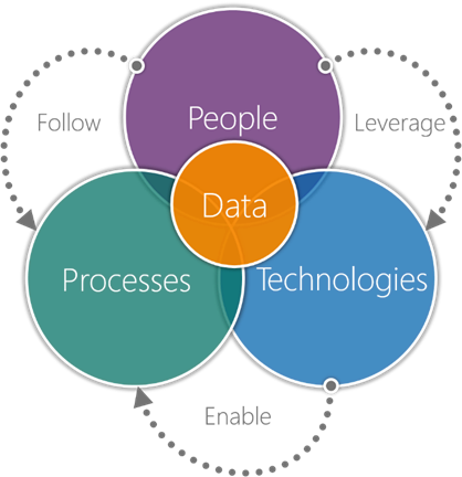
People
In terms of digital transformation and application of digital technology in all aspects of human society, the GeoIginte conference gives us a unique opportunity to envision how geospatial technologies and data will shape the future of Canada.
Location intelligence is an emerging scientific field that is giving rise to new data scientists who will combine the skills and talents from often disjointed areas of expertise (e.g. Geomatics and Sociology, Geomatics and Health, etc.).
It is our vision that GeoIgnite will spur the grassroots of a more diverse ecosystem where diversity of thinking and knowledge will ignite innovation and better outcomes for us all.
We need to work more collaboratively in an ecosystem across Canada, through cross-functional groups focused on innovation and leveraging disruptive technologies, towards achieving Economic and Social Government priorities, and better lives for Canadians.
As part of an ecosystem, and as professionals in government, private sector and academia, we should ensure that younger generations of geomatics professionals will be enthusiastic, committed, and feel that they have a future career pathway. If we, as part of this conference, take the steps envisioned and nurture our grassroots then this will become a reality.
At GeoIgnite, we are committed towards motivating and nurturing future diverse talent. In addition to a planned Job Fair, we will be announcing the annual GeoDiversity Award, which honours a person or an organization affiliated with the geospatial Industry for their extraordinary and unfailing commitment to diversity and inclusion in the workplace and surrounding communities.
Data
As they undergo significant digital transformation programs, organizations and governments across the globe face a series of increasingly complex challenges.
The geospatial data and Location Intelligence (LI) are increasingly being leveraged to reduce complexity, improve data quality, streamline business processes, manage risks better, and increase operational efficiency.
Data is underpinning the journey of digital transformations, so the way your organization leverages data matters. Leveraging a common platform of technical infrastructure, policies, standards and governance through Federal Geospatial Platform (FGP) and Open Maps enable the Government of Canada to make more high-quality, authoritative, and usable geospatial data available in open formats to support innovation and better services for Canadians.
The Federal Geospatial Platform and Open Maps initiatives teach us the importance of open standards for interoperability and the crucial role of cross-functional teams in leveraging disruptive technologies for digital transformation, making information accessible and usable to innovators in academic, private and public sectors.
Processes
In the future, geospatial information will continue to be fundamental to improved decisions and faster growth. Maintaining Canada’s leadership position in this fast-moving, competitive field will depend on innovative researchers in academia, public and private sectors, who are at the forefront of sensor and visualization technologies.
Those who design and steer the development of the technology landscape can mitigate risk by setting operating standards and promoting cross-functional collaboration.
The ability to combine deep computational expertise with creativity and a socially insightful view of the world in the creation of niche apps, will become increasingly important.
Technologies 

Today, geospatial technologies are embedded in many of the workflows that support the Fourth Industrial Revolution and therefore invaluable to users. This means that geospatial information is no longer the domain of specialists and suddenly geospatial information has become a context for the rest of our augmented existence.
Smart applications and on-line mapping tools give the public almost instant access to a wealth of information that is tied to a geographic location, bridging the real world with the digital world. This only will increase appetites for more maps and location data than ever before, but it will not be possible without agreed-upon rules for sharing this data, which is essential for taking advantage of the true potential of this resource.
At GeoIgnite, we will be featuring the work of innovative companies, government and academic research and envisioning how these technologies may shape the future of Canada and Canadians.
We will be your guides through people, data, processes and technologies as important factors for successful digital transformations. We will brief you, beyond buzzwords, on what you need to know about disruptive technologies and processes, from Location Intelligence, AI and IoT to Cloud, Augmented Reality (AR), Blockchain, and Cybersecurity and what they may mean to you and the future of your organization.
Learn more about what you need to participate in the digital transformation by attending GeoIgnite, June 18th-19th 2019!


Be the first to comment