
GoGeomatics Back to School Socials are happening this September! Join us and the Canadian geospatial community as we welcome new and returning students to our sector!
We are looking forward to seeing you at the Back to School Social! Check the links bellow to find the nearest social to you.
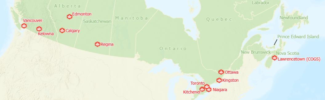
GoGeomatics Back to School Events 2022
| City | Date | RVSP |
|---|---|---|
| Lawrencetown, NS | September 9th | Meetup Info |
| Niagara, ON | September 13th | Meetup Info |
| Kitchener Waterloo, ON | September 14th | Meetup Info |
| Toronto, ON | September 15th | Meetup Info |
| Kingston, ON | September 16th | Meetup Info |
| Ottawa, ON | September 19th | Meetup Info |
| Regina, SK | September 21st | Meetup Info |
| Calgary, BN | September 22nd | Meetup Info |
| Edmonton, BN | September 23rd | Meetup Info |
| Vancouver, BC | September 26th | Meetup Info |
| Kelowna, BC | September 27th | Meetup Info |
GoGeomatics thanks our National and City Sponsors for the 2022 Back to School GoGeomatics Socials
National Sponsors
 The Nova Scotia Community College’s Centre of Geographic Sciences (COGS) provides a focused approach to a broad range of geomatics training and has a strong reputation among employers and geomatics professionals. Small class sizes provide opportunities for a collaborative project-based-learning environment and interaction with faculty & peers. Students use modern technology and get the hands-on training that makes COGS graduates the preferred choice of employers. They also benefit from an applied-learning environment with close connections to research, community, alumni, and industry partners. COGS is home to the Walter K. Morrison Special Collection of cartographic books and maps.
To stay updated, you may also check out COGS on Facebook, Twitter and Instagram.
![]()
![]()
GeoVerra is one of the country’s largest geomatics firms with offices in British Columbia, Alberta, Saskatchewan, Manitoba and Ontario providing land surveying, forestry, environmental, and geospatial solutions to clients in diverse industries. First and foremost, GeoVerra is a service organization that thrives on exceeding expectations and creating lasting relationships that clients can depend on. We’re driven by an entrepreneurial spirit and a relentless work ethic that pushes us to take initiative, developing advanced, customized solutions for clients in diverse sectors from industry to government.
You may also follow GeoVerra on LinkedIn and check out their website for more details.
Meridian Surveys is a leading provider of survey services in the resource, pipeline, and municipal sector. Founded in 1966, they now operate out of ten offices throughout western Canada as well as numerous temporary project-based locations. Their team on average has been with them for over ten years. In the past couple of years alone they have been honoured to award a few team members with service awards for 50 and 45 years of service. Meridian Surveys realize that their people are one of their biggest assets and they offer above average benefits package, profit sharing, and opportunities for continued education.
Dont forget to check out their Facebook, Twitter and LinkedIn.
![]()
![]()
SAIT’s action-based learning, solution-focused research and industry partnerships are helping to shape the next generation of inventors, entrepreneurs and pioneers. SAIT equips students with essential skills for career success in industry. 91% of their grads get hired and 97% recommend a SAIT education. Whether looking to upskill or change careers, SAIT enables lifetime learning through relevant, customized education. SAIT also enhances the global competitiveness of our students and region. With more than 11,000 industry partners, SAIT blur the lines between industry to strengthen the economy.
You may follow SAIT on Facebook, Twitter and LinkedIn to stay up to date.
The University of British Columbia’s Master of Geomatics for Environmental Management (MGEM) is an accelerated, 9-month, professional master’s degree program that provides essential training in the use and application of geospatial tools used to plan, develop, manage, and evaluate programs to protect and regulate natural habitats and renewable natural resources. This 9-month professional master’s program combines a mix of theory and hands-on learning, beginning with a week-long welcome retreat.
Visit their website for more information about the program.
![]()
![]()
The Department of Geomatics Engineering at Schulich School of Engineering, University of Calgary, is a high on demand program. The program ensures to set future Geomatics engineers to navigate the challenges and opportunities of the increasingly interconnected world, where billions of small sensors and web connections are embedded in everyday objects. Graduates of a geomatics engineering program have traditionally been employable in a diverse range of careers. They work in surveying, mapping, positioning and navigation for the building sector, defense, mining, oil and gas, remote sensing, software development, computer graphics, public utilities and government.
Visit their website for more information about the program.
Cansel is Canada’s largest supplier of geospatial and engineering field equipment, integrating sensors, field supplies and office processing software. Cansel helps clients capture, transform and manage data leading to increased field to finish efficiency and profitability. Together, these solutions will ensure efficiency and profitability for your company. Cansel’s portfolio of measurement solutions facilitate a high quality, productive workflow and data exchange to drive efficiency, productivity, safety and value in organizations of all sizes.
Visit Cansel’s website for more information, as well as Facebook, Twitter and LinkedIn
City Sponsors
VANCOUVER SPONSORS
![]()
![]()
TurnTech is a DJI Enterprise drone provider with expertise in helping you select the best product so you can operate your business safely, effectively and economically. From surveying, public safety, natural resource management, agriculture, oil, gas and mining to agriculture, engineering, and construction (AEC) and more, we have drones to fit your industry.
Contact TurnTech today to see how they can be your solution provider! TurnTech can also be reach on Facebook, Instagram and LinkedIn
![]()
![]()
Locate Press is a book publisher, focusing on the open source geospatial niche. Many traditional publishers see geospatial books as either scientific content or geared primarily toward consumers. With more and more technical users using open source geospatial technology (for a wide variety of reasons!), now, more than ever, you need comprehensive and reliable education and training resources. If you are an educator looking for high quality curriculum, Locate Press would like to hear from you. If you have an idea for a new book title or project, please consider submitting a proposal.
We would like to thank Locate Press for also supporting our Kelowna Group!
OTTAWA SPONSORS
![]()
![]()
Esri is the global market leader in geographic information system (GIS) software, location intelligence, and mapping. Since 1969, they have supported customers with geographic science and geospatial analytics, what they call The Science of Where. Esri take a geographic approach to problem-solving, brought to life by modern GIS technology. Esri is committed to using science and technology to build a sustainable world.
To learn more about Esri, please visit their website. You may also follow them on Facebook, Twitter and LinkedIn.

The Department of Geography and Environmental Studies has three programs of study leading to an undergraduate degree in Geography, Geomatics and Environmental Studies. Students can obtain a B.A. or a B.Sc., Honours, or Combined Honours Degree. Their MA, MSc and PhD graduate programs are now accepting applications. Explore research topics and opportunities by checking professors’ research areas and specific project ideas. Explore careers of Bachelor of Arts and Bachelor of Science students who have graduated from our programs.
They also offer a specialization in Globalization and the Environment in the Bachelor of Global and International Studies program.
TORONTO SPONSOR
 Avenza focused on delivering powerful mapping software that facilitates design, publication, and spatial imaging, as well as providing a platform for commercial and recreational users to consume maps on their mobile devices. MAPublisher® is a suite of plug-in tools for Adobe Illustrator, leveraging its superior graphics capabilities for high-quality map creation. Geographic Imager® software enhances Adobe Photoshop to make working with spatial imagery quick and efficient. The Avenza Maps app helps users consume high-quality cartographic products.
Check out their website for more details, as well as their Facebook, LinkedIn and Twitter.
Avenza is also supporting the Niagara and Kitchener GoGeomatics Group. Their support is greatly appreciated.

Soar.Earth was created because the world needs a scalable, collective and accountable knowledge base of all its maps and images. Their mission is to create the world’s largest digital atlas, built on maps and imagery from individuals, organisations, and the broader community. Soar.Earth bring value to our users – to make it quicker and easier to access, share, and interact with maps and images. They see themselves as the next evolution of mapping systems, breaking down existing data silos, and opening up this incredible content to the world.
Visit their website to learn more about Soar.Earth. To stay updated, check out their Facebook, Twitter and LinkedIn.
We would like to thank Soar.Earth for also being a supporter to our Kitchener Group!
KITCHENER/WATERLOO SPONSOR

Headquartered in Waterloo, Ontario, Mappedin is the leading platform for indoor spatial data management, digitizing venues, and building best-in-class indoor mapping experiences. Built for scale, the flexible Mappedin platform and enterprise-grade tools help leading operators and developers around the world to manage their indoor maps and build digital wayfinding experiences into mobile and web-based applications. Mappedin offers a variety of indoor mapping and wayfinding software products including pre-built Digital Directory and Responsive Web software applications, Mobile and Web SDKs, GeoJSON-based exports, and a cloud-based Mapping CMS (Content Management System).
To stay updated, check out Mappedin’s Facebook, Twitter and LinkedIn.

GM BluePlan Engineering Limited is a dynamic engineering, management, and technology consulting company that provides full service and full asset life cycle offerings to our clients across Canada. With over 50 years of experience, GM BluePlan provides expert guidance to plan, design, implement, and support our clients’ infrastructure. GM BluePlan believes in providing a full life cycle of engineering services delivers better decisions and better project results. They have significant depth in their traditional engineering services, as well as their focused infrastructure planning, asset management, and strategic advisory services.
Check out their Facebook and LinkedIn for more details.
CALGARY SPONSOR
![]()
![]()
Providing the data you want in near real-time at a cost you can control is the value Lux Modus provides our customers. Their effort to democratize 3D mapping has created one of the fastest, easiest-to-use and most affordable mapping systems. It provides flexibility in how data is collected, paid for and delivered, all while reducing the cost of ownership to the customer. By lowering equipment costs and eliminating the need for advanced software and specialized training, Lux Modus brings accurate, high-resolution 3D scanning technology to the masses. Lux Modus offers the best value for your dollar and collection time of your 3D data.
Lux Modus is on LinkedIn and Twitter.
KINGSTON SPONSOR
![]()
![]()
The Department of Geography and Planning is an integrated department that studies the earth’s places, societies, environments, and landscapes. The department is unique in bridging the social sciences and humanities (human geography and urban planning) with earth system science (physical geography and environmental planning), and offers BA, BSc, MA, MSc, MPL and PhD degree programs as well as a Certificate in Geographic Information Science and a Certificate in Urban Planning Studies.
Check out their website to learn more about the department and the program.
The Association of Ontario Land Surveyors (AOLS) was established in 1892. It is a self-governing association, responsible for the licensing and governance of professional land surveyors, in accordance with the Surveyors Act. As with all self-governing professions, the AOLS has a responsibility to ensure that the public interest is paramount. The AOLS is governed by a Council, composed of nine Ontario Land Surveyors elected by the membership, the Surveyor General of Ontario, and three to five appointees, or lay members, who are not surveyors (one of which is a barrister and solicitor). The lay members are representatives of the public, appointed by the government to help ensure that the public interest is protected.
Stay connected with AOLS on Facebook, Twitter and LinkedIn.


Be the first to comment