

Free Satellite Imagery For You: Sentinel 1 & 2
Sentinel 2
Sentinel constellations and data products
As the ENVISAT program is coming to an end, the European Space Agency has begun the process to develop the Sentinels family of satellites to fulfill the Copernicus earth observation program. In this program, constellations of Sentinels satellites will carry a range of technologies including radar and multi spectral scanning instruments for collecting data pertaining to land, ocean and atmosphere.
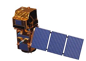
Of the six Sentinels constellations, the polar orbiting Sentinel-1 and Sentinel-2 constellation are the the focus of this article. Sentinel-1 consists of Sentinel-1A and Sentinel-1B satellites which capture land and ocean data through radar sensors while the Sentinel-2 constellation, consisting of Sentinel-2A (operational) and Sentinel-2B (launched on March 07, 2017) will provide multispectral high resolution images for land monitoring.
SENTINEL-1
A constellation of two satellites sharing the same orbit, 180° apart, will cover the entire face of the earth every six days, delivering data to multiple ground stations located around the earth. This Sentinel-1 system also contains a laser data transmission system to deliver continuous data to the geostationary European Data Relay System. The first in the series, these Sentinel-1 satellites transmit advanced radar data for studying the earths surface 24 hours per day, regardless of weather, day-and-night. The Synthetic Aperture Radar (SAR) operates in C-band at a center frequency of 5.405 GHz. The mission paybacks include a variety of services capable of impacting human life and climate. Examples include the monitoring of Arctic sea ice extent, monotonous sea ice mapping, marine environment investigation, oil spill monitoring, ship recognition for maritime security, land monitoring for motion risks, natural resources mapping such as forest, water and soil management as well as mapping to support humanitarian aid and crisis situations.
SENTINEL-1 operates in four exclusive acquisition modes (depicted in figure 1):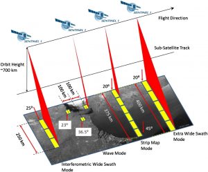
- Stripmap (SM) – allows coverage with 5 meter by 5 meter resolution over a narrow swath width of 80 km.
- Interferometric Wide swath (IW) – provides a large swath width (250 km) with a moderate geometric resolution of 5 m by 20 m.
- Extra-Wide swath (EW) – works similarly to the IW mode using five sub swaths instead of three, resulting in a lower resolution of 20 m by 40 m.
- Wave mode (WV) – acquisitions are composed of stripmap imagettes of 20 km by 20 km.
Figure 1: Sentinel-1 data capturing mods (source: ESA)
SENTINEL-2
This mission also comprises twin polar-orbiting satellites sharing the same orbit plane, 180° apart. The mission, once fully operational, will be to monitor the variability in land surface conditions with a global coverage limit from between latitudes 56° south to 84° north. This series will capture data in a wide swath and with a high frequency (on the equator, 10 days with one satellite and 5 days with two satellites) in multispectral bands. Sentinel-2 Satellite images are acquired on 13 spectral bands ranging from visible to Near Infrared (NIR) and Shortwave Infrared (SWIR) which spatial resolutions per the following summaries:
- Four bands at 10 m (Figure 2) : 490 nm (B2), 560 nm (B3), 665 nm (B4), 842 nm (B8)
- Six bands at 20 m (Figure 3): 705 nm (B5), 740 nm (B6), 783 nm (B7), 865 nm (B8a), 1 610 nm (B11), 2 190 nm (B12)
- Three bands at 60 m (Figure 4): 443 nm (B1), 945 nm (B9) and 1 375 nm (B10).

Figure 2: 10 meter bands (Source: ESA)

Figure 3: 20 meter bands (Source: ESA)

Figure 4: 60 meter bands (Source: ESA)
Sentinel data products (freely available) and download procedures will be discussed in a future article.


Congrats Luqman, may Allah pak give you success in every field of life and may you get everything you deserve by the Grace of Allah pak….
Congrats Again *****