
The GeoIgnite annual conference 2020 was power packed with discussions and presentations about compelling technologies, impressive scientific advancements and upcoming government initiatives in the Geospatial sector. Covid-19 did not hamper the event, and in fact going virtual allowed our audiences to expand exponentially.
What is Hydrospatial?
Geospatial generally refers to the dry or land side of spatial information, while Hydrospatial refers to the wet or marine side of spatial information.
A simple explanation of the term Hydro-spatial by Denis Hains
The Hydrospatial presentation (attached below) is a 45 minute informative session that touches upon the Ocean, Coastal and Marine Science and the importance of spatial Management for the Blue Economy, with some captivating demonstrations of the science behind it.
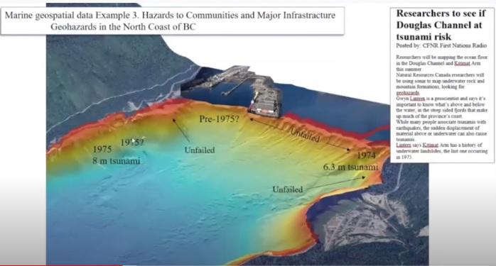
Geological Survey of Canada’s approach towards coastal hazards
Beginning with a warm welcome and some interesting insights into science quotient of hydro-spatial by Denis Hains, the President and CEO of H2i (Hains Hydrospatial International Inc.), the first half is co-presented by Dr. Daniel Lebel, Director General and Dr. Gwyn Lintern – Section Head at Geological Survey of Canada who discuss in detail, about the importance and scientific techniques of coastal hazard evaluation, GSC’s predictive approach towards Geohazards, climate change risk reduction and resource assessment. Demonstrated with exemplary samples of satellite imagery, storm surge affected areas, Tsunami 9.2 digital simulation and geospatial analysis, the presenters also talk about proposed projects in Northern BC, as a result of detailed research and analysis of tsunami history in Kitimat, BC and the presence of fault lines across the western coast.
Canadian Hazard Information Service & Canadian Hydrographic Service
The team also discusses the use of two important services, that have been leveraged by the Geological Survey of Canada; the Canadian Hazards Information Service and Canadian Hydrographic Service. Stay tuned to know more about these services in the second half of session.
Click here if video does not play on your device
Tsunami Hazard
The second half of presentation is co-presented by Mark LeBlanc, Director, Canadian Hydrographic Service and Dr.David McCormack, Executive Director, Canadian Hazard Information Service.
Tsunami Monitoring and Alerting System
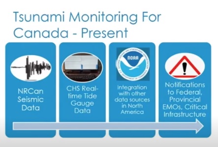
The presenters begin with explanation of the science behind Tsunami and the existing monitoring and alert system in Canada. It is a process involving seismic real-time data from NRCAN’s seismographic network (~200 sensors distributed across the country) , being sent to National Tsunami Warning Center, Palmer, Alaska, integrated with other data sources from NOAA. This data is then supplemented with real-time tide gauge data from the Canadian Hydrographic Service , buoys data, data from other jurisdictions, satellite images and presented to scientists at the Tsunami Warning center. Scientists then review an overall picture of events and in case of probability of a Tsunami event, it is promptly notified from National Tsunami Warning Center to Federal Government, Canada.
GeoIgnite is Canada’s National Geospatial conference hosted by GoGeomatics Canada. GeoIgnite was held online using Zoom between July 22nd to 24th, 2020. This free event showcased Canadian geospatial community and leaders of Canada’s location technology sector. The conference brought together professionals from government and industry for innovative programming and updates on our sector. Every year GeoIgnite is a unique opportunity for the geospatial community in Canada and abroad to learn, share, and engage with one another at our virtual conference.


Be the first to comment