
This article was reprinted with permission from the Ontario Professional Surveyor, Volume 56, No. 3, Summer 2015
By Theresa Nicholsi, Scott Youngblutii, Jonathan Mooreiii and Ryan Harrisiii.
The 2014 discovery of HMS Erebus, one of Sir John Franklin’s two lost ships, solved a key part of a mystery stemming back over a century-and-a-half, which saw the doomed ships beset in ice in 1846 while searching for Canada’s Northwest Passage. None of the crew survived the expedition. Its companion vessel, HMS Terror, remains to be discovered.
Since 2008, Parks Canada has led a collaborative effort searching for the lost ships. Throughout these searches, Parks Canada garnered the support of numerous organizations that contributed to research and surveying efforts. Partners for the 2014 search included Fisheries and Oceans Canada (the Canadian Hydrographic Service and the Canadian Coast Guard), the Government of Nunavut, Environment Canada’s Canadian Ice Service, the Canadian Space Agency, the Department of National Defence (Royal Canadian Navy and Defence Research and Development Canada), and the privately funded Arctic Research Foundation. New to the project in 2014 were the Royal Canadian Geographical Society, the W. Garfield Weston Foundation, Shell Canada, Lion TV and One Ocean Expeditions.
On September 1st, a breakthrough clue that ultimately led to the location of the wreck of HMS Erebus was found on an island in eastern Queen Maud Gulf. A heel of a davit from a British naval ship was found by the helicopter pilot from the Canadian Coast Guard icebreaker Sir Wilfrid Laurier, Andrew Stirling, while conducting ground surveys with the Government of Nunavut’s archaeological team, Doug Stenton and Robert Park. A Nunavut-federal joint News Release outlining the find and related images of the artefacts was issued on September 8, 2014.
Following the land-based find, Parks Canada marine archaeologists amended their target search area using their own survey and diving boat R/V Investigator, deployed from CCGS Sir Wilfrid Laurier. It would be the side-scan sonar of R/V Investigator that would capture the first images of the nearly intact ship sitting upright on the seafloor.
A subsequent inspection by Parks Canada’s using its remotely-operated vehicle (ROV) confirmed the wreck as one of Franklin’s, seen for the first time after more than 166 years of searching. Later, two days of diving operations by Parks Canada’s marine archaeologists would provide invaluable first-hand views of one of Franklin’s ships, all of which was captured by underwater camera and video systems. This find would also confirm Inuit oral history of a ship having been seen in this general area. Canada’s Prime Minister announced the discovery on September 9, 2014.
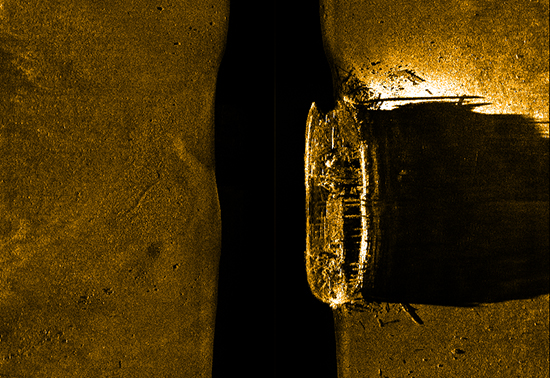
Side-scan sonar image of the historic shipwreck HMS Erebus as it rests on the seafloor. © Parks Canada, 2014
Working around the diving operations, it fell to the Canadian Hydrographic Service to collect high resolution bathymetric data using multibeam sonar equipment, a cutting-edge technology that transmits hundreds of beams of sound through the water to help paint highly detailed images of the seabed. This technology was installed directly onto two hydrographic survey launches, CSL Kinglett and CSL Gannet, with teams of hydrographers and Coast Guard coxswains, who were tasked to survey the shape and depth of the arctic seabed and to detect all hazards to navigation.
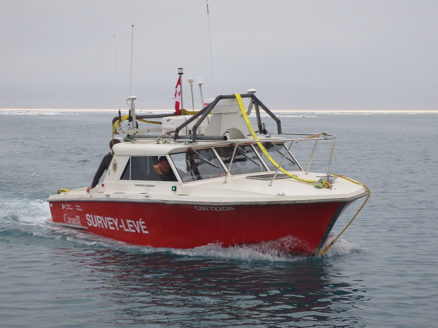 CSL Kinglett conducting surveys in the Arctic.
Photo credit: Christine Delbridge, Canadian Hydrographic Service, 2014
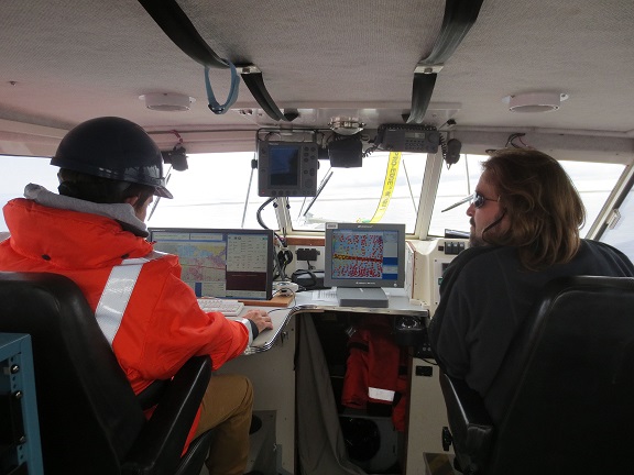 Hydrographers Marcus Beach and Arthur Weickens inside CSL Gannet.
Photo credit: Christine Delbridge, Canadian Hydrographic Service, 2014
However, in this instance, the high-precision data collected from the Canadian Hydrographic Service multibeam sonars were used to produce three-dimensional images and a digital fly-thru of the shipwreck. This detailed information was used by the marine archaeologists, along with other side-scan sonar data and visual observations made during preliminary dive operations, to confirm the identification of the wreck as the lead vessel in the original 1845 expedition. The official announcement of the ship’s identity as HMS Erebus was made in the House of Commons on October 1, 2014.
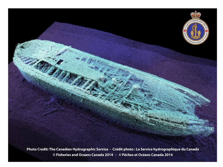 Multibeam image of HMS Erebus. The ship image is false-coloured using a blue palette in order to highlight key features, depth and shape of the shipwreck located in Queen Maud Gulf.
© Canadian Hydrographic Service, Fisheries and Oceans Canada, 2014
On April 1, 2015, officials from Fisheries and Oceans Canada joined with New Brunswick -based geospatial software company CARIS and Calgary- based geomatics technology innovation support centre TECTERRA to unveil high precision 3D printed models of HMS Erebus. The high precision models were printed from the multibeam sonar data collected by the Canadian Hydrographic Service. The bathymetric measurements were processed in seafloor mapping software created by CARIS and exported for use in a 3D printer provided by TECTERRA.
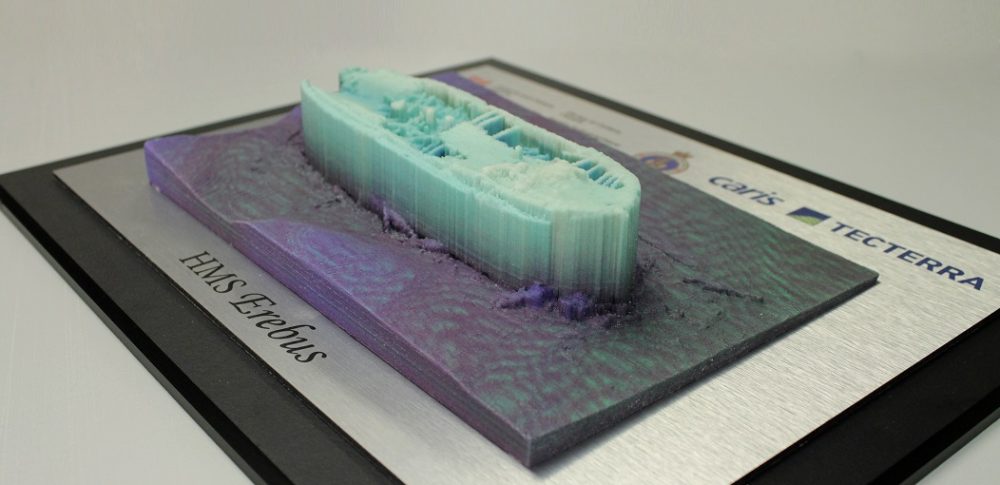
The level of detail in the models provides a clear view of the vessel’s current structure, and even shows details of the wooden beams and materials surrounding the wreck, as well as one of its anchors that rests off the port side. Being able to generate the models added extra value for Parks Canada archaeologists and divers from the Royal Canadian Navy’s Fleet Diving Unit Atlantic for their spring dive operations conducted in April into the wreck as part of Operation NUNALIVUT 2015.
And while the archaeological achievements are extraordinary, the project continues to successfully demonstrate the value of such collaborative multi-disciplinary ventures, yielding advancements in areas of sovereignty, marine safety, environmental protection, science, history and culture.
Project summer planning is currently underway for 2015, with the team anticipating further investigation of HMS Erebus and a continued search for HMS Terror.
i Communications, Fisheries and Oceans Canada
ii Canadian Hydrographic Service, Fisheries and Oceans Canada
iii Underwater Archaeology Team, Parks Canada


Be the first to comment