
These days drones are all the rage. Nevertheless, there are other ways to collect data from the sky! Blimps, balloons and kites are alternative was to collecting data or remote-sensing imagery. These are great unconventional solutions for small scale, high resolution projects.
Blimps
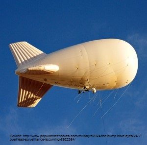
There are three types of airships: rigid, semi-rigid and non-rigid. A rigid airship has a metal skeleton lining the inside of the balloon. The semi-rigid has a keel which runs the length of the ship. While the non-rigid one (better known as a blimp) has a completely soft shell envelope [1] [2].
How Blimps Work?
You have probably heard that blimps are the way of the future! They certainly are when it comes to cutting down emissions. Blimps are generally engine-less making them steady and vibration free. Their speed only reaches 50-80 km per hour (30-50 mph) but can reach 110 km per hour (70 mph) with a tailwind making them slow in comparison to airplanes [3]. Blimps generally rise to the height of 500 – 1800 m (1500 – 3000 ft) but can go as high as 25 000 –30 000 m (8000 ft) into the troposphere before any buoyancy issues arise [3] [4].
The blimps envelope is much larger in comparison to its platform because it has to contain a large volume of gas to carry the platform weight easily. What makes blimps fly is how the helium is expands and contracts in the envelope hull. At sea level, helium takes little space in proportion to the air. When the ship ascends the helium expands making less outer pressure and pushing the air out with the help of air valves allowing for a smooth ride [4].
How Blimps Collect Data?
Fully automated blimps are cost effective unmanned platforms that are controlled remotely. Self-sufficient blimps are nearly here. Data collection can be performed by formatting a GPS navigation flight path using solar power to drive the ship [5]. Although blimps allow for greater coverage, this method requires a team of people to operate safely and a site with restricted access for launching [6]. These structures are great for collecting data because they stay aloft for a long time consuming little or no energy [1]. The structure of the airship provides a long-endurance aerial platform that flies low creating a good environment for long term observations of an area [7].
Balloons
The earliest weather balloon recorded was in 1898 by French meteorologist Leon Teisserenc de Bort who was amongst the first to find that the tropopause and stratosphere existed. From the 1930s onward, radio tracking systems had been invented. Ultimately they turned balloons into floating weather stations. The sophistication of elongated balloon, in combination with the advancement of atmospheric monitoring equipment, have enabled us to observe the edge of our outer space [9].
How Are Balloons Used?
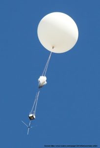
High altitude balloons typically collect weather data, such as temperature, wind speed, humidity, atmospheric pressure and changes in the environment. They do not require an engine or fuel and are filled with helium gas [10] [11], resembling blimps. They are tethered to a lightweight cardboard box called a radiosonde which contains scientific measuring instruments and a flight video [10] [11]. Balloons will lift to the edge of the stratosphere, rising higher as atmospheric pressure decreases, expanding the balloon until it pops. For instance, a 2 m diameter balloon will expand to 10 m and after surpassing its threshold, the radiosonde will parachute its way back to earth’s surface and the data is then recovered for further analysis [12]. Check out Figure 2 for what a weather balloon looks like.
How Balloons Collect Data?
When the balloon is in the air it obtains vertical observations of the atmosphere transmitting the results back to a receiving station on the ground [13]. The longer flights may last days and even months [13]. Canada’s federal government launches about 10 balloons per 6-8 weeks campaign on average. Launches typically occur in the early morning or late evening, weather permitting, when the winds are lowest [14].
For more information on Canada’s federal government balloon launches please visit this link.
Kites
The earliest recording of a kite being used for observation was around 200 B.C. General Han Hsin used it to find out how far a tunnel would need to be dug in order to get to the other side of the wall. He successfully surprised the enemy [15]. Not surprising that kites have measured stationary observations.
How Do Kites Fly?
Similar to a plane, a kite need weight, lift, drag, and trust to fly. Blimps and balloons also use these forces however a kite reacts more similarly to a plane in that its weight is heavier than air. A successful kite launch must have more lift than weight. To keep the kite in flight the four forces have to be balanced; the upwards lift needs to be equal to the downward weight and the forward thrust needs to be equal to the backward moving drag [16].
How Kites Collect Data?
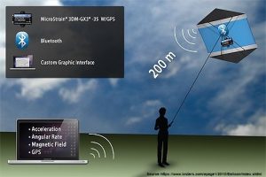
Kites are great for hovering over a site at various altitudes to take high resolution images [7]. Using a kite to collect data is one of the oldest forms still used and the operational complexity is lower than blimps or balloons. Kites have come a long way where designs have been developed up to the point of having the ability to launch in winds as low as 5 km (3 mph) [6]. Technology has come a long way as well in miniaturizing digital sensors and multi-spectral imaging systems, thermal imagers, normalized difference vegetation index (NDVI) and digital infrared cameras [6] [7]. Other possible data collection can gather digital surface models (DSMs), LIDAR, and mobile laser scanners (MLS) [7].
All you need is an Arduino or Raspberry Pie kit, a lightweight camera, the right lens, a wireless connection and a computer or mobile device interface to receive data (Figure 3). There are a multitude of free 3D printing templates and tutorials online to customize rigs to hang equipment off of a kite, such as a pendulum or picavet mount for a great nadir view [6].
Conclusion
Blimps, balloons and kites are great ways to collect data for your clients’ needs and can even be better than using a drone. With all the information out there nowadays we can pick and choose the best method from a variety of solutions to use in a range of environmental conditions.
Notes
- Freudenrich, Craig PH.D. 2016. How blimps work. How stuff works. Science Modern. <http://science.howstuffworks.com/transport/flight/modern/blimp2> Accessed 2016 November 24.
- From Encyclopedia.com: How Products are Made, Airships 1996. <http://www.encyclopedia.com/science-and-technology/technology/aviation-general/airships>. Accessed 2016 December 6.
- From Skyship Services Inc.: FAQ page. <http://www.skyshipservices.com/faq.html>. Accessed 2016 November 24.
- Luhe Hong, et al. 2015. Coordinated Control of Pressure Difference and Rising Velocity for Stratospheric Airship with Thermal Effects. Mathematical Problems in Engineering, vol. 2015. Google Scholar <https://link.springer.com/article/10.1007/s10015-007-0451-y>. Accessed 2016 November 24.
- Kantor, George et al. 2001 October 28-29. Collection of Environmental Data from an Airship Platform. SPIE Conference on Sensor Fusion and Decentralized Control IV, vol. 4571, pp. 76-83. <https://www.ri.cmu.edu/pub_files/pub3/kantor_george_a_2001_1/kantor_george_a_2001_1.pdf>. Accessed 2016 November 24.
- Duffy P. James & Anderson Keren 2016. A 21st-century renaissance of kites as platforms for proximal sensing. Sages Publication Progress in Physical Geography Vol. 40(2) 352 – 361. Google Scholar <http://ppg.sagepub.com/content/40/2/352.abstract. Accessed 2016 November 30.
- Klemas Victor V. 2015 September. Coastal and Environmental Remote Sensing from Unmanned Aerial Vehicles: An Overview. Journal of Coastal Research Online, 31(5), 1260-1267.Google Scholar < http://www.bioone.org/doi/abs/10.2112/JCOASTRES-D-15-00005.1>. Accessed 2016 November 24.
- From Encyclopaedia Britannica: Jean-Pierre Blanchard 2016 September 27. <https://www.britannica.com/biography/Jean-Pierre-Francois-Blanchard. Accessed 2016 December 5.
- From Stratoscience near space scientific missions: Stratoscience – Weather balloons history. <http://www.stratoscience.com/weather-balloons-history/>. Accessed 2016 December 5.
- From Canadian Space agency: What is a balloon? 2015 July 31. <http://www.asc-csa.gc.ca/eng/sciences/balloons/what.asp>. Accessed 2016 November 28.
- Hopper, Tristin 2016. How stuff works Science: How weather balloons work. <http://science.howstuffworks.com/nature/climate-weather/meteorological-instruments/weather-balloon> Accessed 2016 November 24.
- From High Altitude Science: Intro to Weather Balloons 2016. <http://www.highaltitudescience.com/pages/intro-to-weather-balloons>
- From NOAA: Weather Balloon Data. <https://www.ncdc.noaa.gov/data-access/weather-balloon-data>. Accessed 2016 November 24.
- From Canadian Space agency: What is a balloon flight? 2013 July 4. <http://www.asc-csa.gc.ca/eng/sciences/balloons/flight.asp>. Accessed 2016 November 28.
- From Gomberg Kite productions International, Inc. <https://www.gombergkites.com/nkm/hist1.html>. Accessed 2016 December 6.
- Hulsander, Michael 2012April 26. Smithsonian National Air and Space Museum: How kites fly. <https://airandspace.si.edu/stories/editorial/how-kites-fly>. Accessed 2016 November 30.


Be the first to comment