

Geospatial Niagara: Day of Geography, ihub, Geoparks, TreeOcode, & St. John’s Declaration

It’s hard to believe that it’s been over a year since my post introducing Geospatial Niagara to GoGeomatics Canada readers. So much has happened since then that we’re tremendously excited about. If you’re not familiar with Geospatial Niagara, you can see the introduction article here. Now that there is a moment (however small) to breathe, I was encouraged to provide a little update. My thoughts are that doing so provides a two fold benefit. 1) It showcases the work that we’re doing here in the Niagara region to promote community based geographic education and the use of geospatial technologies and information. Perhaps this will attract interest in the Niagara region and our assets – Brock University and Niagara College geography/GIS programs. 2) Demonstrate that what we’re doing here in Niagara can be done in other communities in order to engage citizens/students in the importance of Geography and Geographic Education (Remember that St. John’s Declaration?).
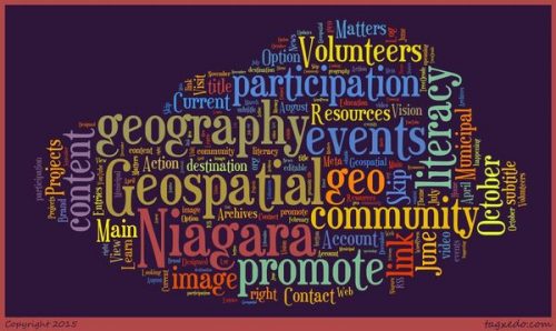
Geospatial Niagara’s Vision:
A Niagara in which all citizens are engaged citizens through geographic awareness and access to geospatial technologies and geospatial information.
Geospatial Niagara’s Mission:
To promote geo-literacy and community participation through geography.
Update:
The most visible update has been to the Geospatial Niagara website. The revamp was done with the assistance of Niagara Research e-business voucher. We wanted to have a site that showcased our projects and yet immediately showed the impact that we are having in our community. Upon visiting the site, the ticker shows the number of intern projects that we have sponsored or facilitated, the real world value of those projects, the number of trees in treeOcode, the eco-benefit value (see below), the number of posts on Day of Geography (see below), and a tally of the number of students that we’ve had the privilege of speaking with about geographic education and geo-careers. This currently stands at 1660 students across the Niagara region.
Perhaps the most exciting updates come in the form of our recent partnerships and affiliations. Back in July of 2015 through our local business incubator Innovate Niagara – we became part of ihub – an Educational Research and Innovation Hub located in the DSBN Academy in St. Catharines. What brought us there was our Niagara Minecraft Project.
Niagara Minecraft Project
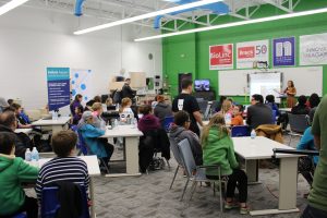
Photo by Ashley Northcotte
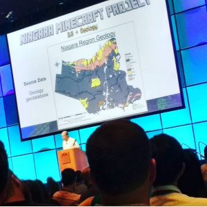
I’ve written about the Niagara Minecraft Project before. It was (is) a project to convert the Niagara region into a 1:1 scale Minecraft map. Using ESRI ArcGIS and Safe Software FME (and lots of support by Safes Dmitri Bagh), two student consultants from the Niagara College GIS program – Adriana and Bogdan – were successful in replicating Niagara’s roads, hydrology and topography into a 1:1 scale Minecraft map. The challenge is that it’s a huge map in terms of file size (50GB).
The next goal was to condense the file size and yet incorporate the geology of Niagara. Two other student consultants – Celeste and Chris – were tasked with completing this and they too were successful, reducing the size of the full region to just over 500 MB. You can see the some of the results at the Niagara Minecraft Project site (a work in progress).
via Instagram – Glenn Letham
We were super excited that Dimitri Bagh of Safe Software delivered a 5 minute lightning talk the the 2016 San Diego ESRI UC about the Niagara Minecraft project. If any readers out there witnessed this presentation and took pictures, please send them to us. We’re a little disappointed that the lightning talks weren’t available online or recorded.
In November 2015 at the end of Geography Awareness Week, we held a Niagara Minecraft Hackathon at the DSBN Academy. 60-70 students ages 6-18 came out to play on the original 1:1 scale Minecraft Maps. There were some challenges that we have learned from and we are hoping to do another one this year to wrap up Geography Awareness Week 2016.
Joined Brock University ESRC
The other affiliation came in June of 2016 when Geospatial Niagara became an Institutional Affiliate of Brock University’s Environmental Sustainability Research Centre. Being a part of the ESRC is a natural fit for Geospatial Niagara in terms of our desire to promote geographic/environmental education to the broader community and to exemplify how geospatial technology can be used within an interdisciplinary context. We’re optimistic that this affiliation will allow us to expand the impact of the TreeOcode Niagara program across Niagara as well as assist in our efforts to bring a Global Geopark to Niagara. We’re excited about the upcoming school year!
TreeOcode has perhaps grown the most over the past year. With thanks to the release of the City of St. Catharines municipal street tree inventory, we have now brought in over 16,000 trees with more to come.
The TreeOcode Niagara project is a community/student engagement project that utilizes Open Tree Map to create a crowd sourced community managed urban forest inventory. treeOcode has been in 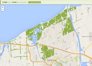 existence for about 2 years now and we began by collecting tree data within the cities public parks. With the species and diameter of the tree collected, the program calculates the yearly ecosystem benefit of each tree in terms of energy conservation, stormwater filtered, air pollution mitigated, CO2 absorbed and CO2 sequestered. We have recently surpassed the $1 million dollar mark in Eco-benefits. You can see our treeOcode Niagara map here. We’re hoping to expand more into other communities in the near future and to be able to engage more students to educate them in the value of the urban forest but also how treeOcode uses/promotes geographic concepts and promotes various careers. “Like” us on Facebook.
Day of Geography 2016
Day of Geography for 2016 will be happening on Monday, November 14, 2016. This year will mark the third year for Day of Geography. We encourage all geographers, geospatial professionals and environmental professionals to participate by blogging about their work day for the benefit of students across North America and around the world. Please join us this year and blog about your work day! You can write your post on the Day of Geography or prepare it in advance. The goal is to expose students to the multitude to careers that are obtainable with a geographic education. You can login and create your account via Facebook, Google or LinkedIn. It’s a great way that you can give back to your community and share your passion for what you do.
Social Media
We have over 750 “Likes” on our Facebook page and since the creation of the Day of Geography event, the website has been visited by people from 147 countries and almost 3000 cities around the world! Our top ten countries include:
The United States, Russia, Canada, The UK, India, Brazil, China, Australia, Germany and Portugal.
 The Niagara Aspiring Geopark project continues to move forward. We’ve just submitted a progress report to the Canadian Geoparks Network and we’re hoping to put together the working group that will work on the official application.
If you are not familiar with the concept of geoparks, please visit the Global Geoparks Network website.
Into the Future:
So what’s on the horizon for Geospatial Niagara? These are exciting times and we feel that we are on the cusp of something great. But that doesn’t come without challenges. These come mostly in the availability of funding (we have none) but also with accessibility to software and, of course, time (since I also work a F/T job). But we have seven great volunteers working with us in various capacities and we’re always on the lookout for other passionate people willing to provide their talent and skills.
We have some exciting projects coming up for the 2016/17 school year. Two of these relate to treeOcode – using remote sensing to delineate urban forest canopy, the other using the Open Data that was released to visualize any manner of benefit to the city that the release of this data can provide back to the community. The main goal, along with bolstering treeOcode is to illustrate to our local municipalities the amazing research and information that can be gleaned from the release of Open Data and how engaged a community can be.
Another project revolves around complete streets and is a continuation of a project started as an internship at Brock University last school year.
The Niagara Minecraft project will move forward with the scheduling of meetings with IT staff and champion teachers to bring it to the class room and design learning modules around it. Celeste has been brought on board in response to our connection with the JerseySTEM program in the US. She will be volunteering her time designing and delivering distance education materials in the form of webinars to teach high school students how they can bring their own geospatial data into ArcGIS or QGIS and FME to create Minecraft worlds. It is a very ground up approach as some of the participants may have not been exposed to GIS software before.
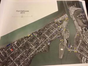 We’ve been doing so much work with local neighbourhood/community groups that we are working towards building what we’re calling the Niagara Community Coalition. The goal of this project is to connect neighbourhood and community groups together to share resources, information and ideas as a kind of support network and to be able to engage them in how the collection and analysis of geospatial data can assist them in beautifying their communities and help them with issues of importance to them. Geospatial Niagara became involved with one local group called the Port Dalhousie Beautification and Works Committee and we sit on their advisory committee with respect to data collection and visualization when needed.
Working within the broader community is an amazing feeling. Recently, during one of the BWC’s public meetings we brought photo maps of the neighbourhood and asked the residents to participate in data collection using sticky-dots. We asked them questions like where are their favourite locations to spend time, where should the BWC concentrate resources, or where would you like to see a BWC project started. We turn these types of events into a participatory geography opportunity. The best comment we heard that evening was, “Who thought geography could be this much fun.”
Geography Radio Show
 Finally, we are currently working towards creating a Geospatial, Geography, Environmental based radio show that will be airing on our local Brock University Campus/Community radio station CFBU 103.7. We are even creating an internship around the creation and development of the radio show. It will be topical in terms of addressing issues being tackled in Niagara (from a geographic perspective). We plan on having segments highlighting geographic/geospatial research being conducted at Brock and abroad, and highlighting careers in geography and related fields. We want to make this show available to and relevant for educators to be able to use in their classroom or for them to promote to their students.
And of course we are looking forward to hosting the Niagara GoGeomatics Back to School Social on Saturday, September 24, 2016. Please join us for this fun free event and meet me and some of our Volunteers. Use the link above to RSVP.
The work continues…..
Thank you for reading. If you have any questions please don’t hesitate to contact me by using the links below.


HI Darren, Thanks for providing this update on all the great work you are doing. It’s great to see how successful you have been in your vision for a Niagara that is using geomatics for the benefit of the community and especially all those students. I look forward to your radio show!