
- Zalak’s Pick: Vodafone’s New 3D Digital Twin Aids Engineers
- Farzaneh’s Pick: UAVs Uncover Italy’s Hidden History
- George’s Pick: Satellite Imagery Used To Confirm and Verify Iran’s Protests
- Ken’s Pick: Opportunities in Geospatial’s “Golden Era”
- Jake’s Pick: Satellite Images Speak for the Amazon Rainforest
- Alefiya’s Pick: Moving Into A Wildfire Zone
Zalak Bhavsar, GIS Technologist, City of Winnipeg, Zalak’s Pick: Vodafone’s New 3D Digital Twin Aids Engineers
Engineers can expect assistance when trying to improve and expand mobile networks.
Vodafone has created a 3D digital twin that will help decision-making and service improvement without customers needing to leave their seats. The digital twin is of Vodafone’s UK mobile mast network. 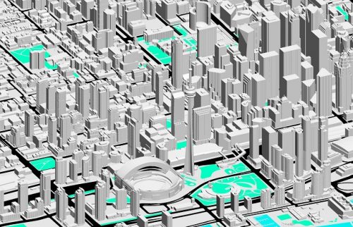
Esri’s advanced software was used to map over 40 million environmental features to produce this digital twin. The outcome is a 360-degree virtual view of the network, available from a laptop or mobile device. This creates effective planning and identifying needs or issues of mobile sites, as it will help engineers inspect and deal with such issues or needs instantly, without having to drive all the way to the site. Esri’s ArcGIS Enterprise was used to add a spatial dimension to the data collected. The digital twin can now share the information in 3D.
Germany and Turkey are next on Vodafone’s list of places to test their digital twin.
Vodafone’s digital twin will help engineers be smarter, faster, more efficient, and reduce carbon footprints.
Farzaneh Farshad, Business Analyst, Farzaneh’s Pick: UAVs Uncover Italy’s Hidden History
Current and future excavation sites now have added protection from destruction and loss of information.
The latest digital methods allow faster, non-invasive identifying of archaeological sites with the assistance of fixed-wing drones and multispectral cameras. Such technology was used by a Duke University research team, headed by University Professor Dr. Maurizio Forte, to map a village in Italy called Doganella.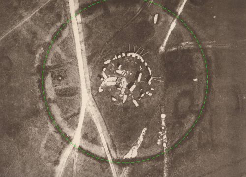
A combination of geospatial data recording, remote sensing, and drone photogrammetry was used to create a 3D replica of the entire site. The team is using the technology to uncover structures and artifacts. Most (95%) of the archeological remains at the Doganella site and a sister site remain buried, and can only be reached by remote sensing.
Team leader, Dr. Forte, decided to use the drone to collect data over the vast area of the sites. A long-range, fixed-wing drone ( AgEagle’s eBee X) and a RedEdge-MX Sensor were used, allowing the data to be collected quickly and easily. The drone easily recorded data over present-day landscapes and terrain. Using this technology saved the project time and money as no extra equipment needed to be brought to the site.
The result was an accurate, multi-layered archeological landscape. The use of this non-invasive technology has paved the way for future excavations using digital methods.
George Petropoulos, GIS Technician, George’s Pick: Satellite Imagery Used To Confirm and Verify Iran’s Protests
The shocking scenes from Iran’s October 2022, protests were verified by Satellites.
Videos and photos were sent to BBC journalists by those living the experiences. Independent media and BBC journalists are not permitted to report in Iran, so the videos and photos were essential to discover what was really going on. Internet service was disrupted by Iranian authorities, causing limited information to be released. Any videos and photos were sent to BBC Persian.
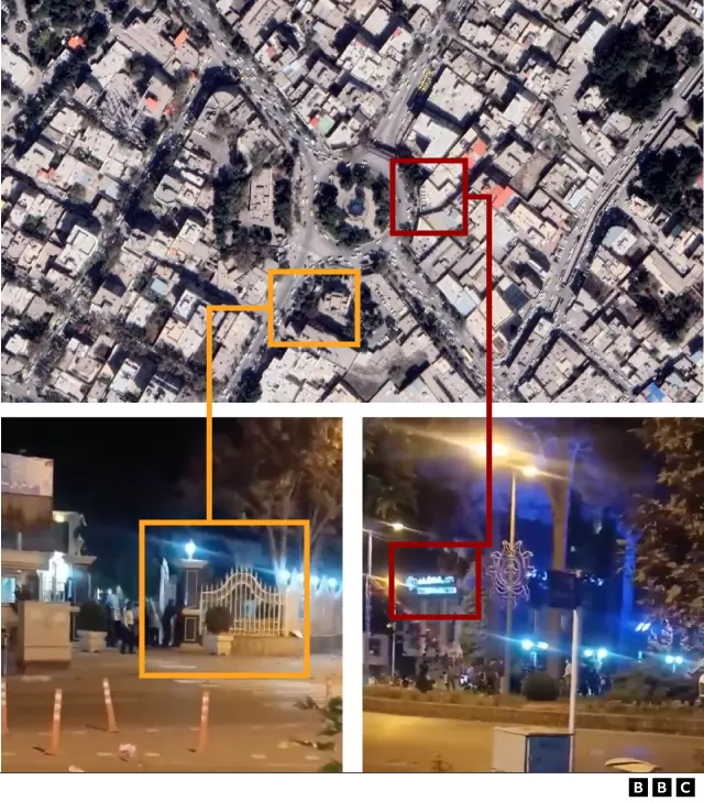
Videos must have a place and time verified before being reported. This is where satellites proved helpful.
Location is confirmed by landmarks and satellite images, including street-level photos, past footage, weather reports, and sun position.
Assaults, detaining, protests, crackdowns, and shootings have all been investigated because they were verified by satellite imagery.
Ken Ang, Geospatial Specialist, Ken’s Pick: Opportunities in Geospatial’s “Golden Era”
There are several trend shifts during 2022.
Geospatial data has become crucial in decision-making in several markets. There is a demand for geomatics worldwide. Surveying and Mapping professionals are expecting an increased need for large amounts of fast and reliable data.
Unmanned aerial systems, portable and mobile mapping systems, artificial intelligence (AI) post-processing software, GNSS receivers, airborne laser scanners, digital aerial cameras, point cloud processing software, building information modelling (BIM) software, GIS software, and photogrammetric imagery processing software are all part of the currently trending systems and software.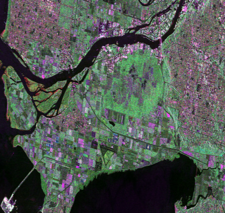
AI is gaining traction because machine learning platforms are now easier to use, open-access spatial data is becoming more available for public use, and there is increased computational power.
There is currently an abundance of work for surveyors and mappers, but recruiting and properly trained personnel are still topics of concern. Most work can be done from an office now, and surveying engineers are moving towards geospatial data managers.
Climate change affects us all, and the diversity of the geospatial industry will bring different solutions to similar problems we all share.
Jake MacLean, Intermediate Geospatial Technician with MDA, GIS Analyst with Statistics Canada, Jake’s Pick: Satellite Images Speak for the Amazon Rainforest
The satellite images of the Amazon rainforest speak loudly.
Over the last several decades, satellite images have shown 75% of the Amazon Rainforest is losing resilience. Vegetation is slower to regenerate and is drier than before.
This is evidence of an approaching “tipping point,” from which the forest will experience a horrible, irreversible dieback. It will cause the rainforest to become a savanna in mere decades.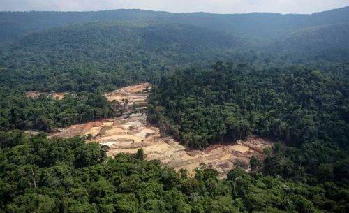
The Amazon pulls billions of tons of carbon dioxide from the air and stores it in its vegetation. The canopy prevents the soil underneath from drying out, but man-made deforestation and warming have disrupted this system.
Soon the forest will lose too many trees to recover.
Satellite imagery shows the Amazon is close to “tipping.” Images of tracts of the forest that haven’t been affected by deforestation are showing the slowing of regeneration over the last 20 years. Several years of greenhouse gasses will be unleashed into the air.
A dieback of such magnitude will affect millions of people in the ecosystem, but if deforestation is dealt with, the rainforest has a chance to recover.
Alefiya Dungrawala, Volunteer Writer for GoGeomatics, Alefiya’s Pick: Moving Into A Wildfire Zone
Climate change has influenced where we want to live, but is it worth relocating into an environmental hazard zone?
A ten-year study by the University of Vermont Gund Institute for Environment found people are moving from hurricane-afflicted areas to areas affected by wildfires. Climate change is increasing this environmental hazard. Data was taken from the county from 2010-2020. 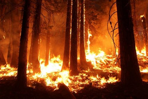
Net migration rates, natural amenities, natural hazards, and socioeconomic factors for every county in the USA were collected and studied. Natural features such as climate, water bodies, topographic diversity, and forest cover were also part of the study.
There were two trends over the last ten years. People are either moving to metropolitan areas (hot summers) or moving to areas with wildfire risk.
Technology (such as air conditioning) may struggle to keep up with demand and health will eventually be affected.
The study authors hope their data will be used to bring awareness and evidence to the climate change crisis.


Be the first to comment