
How Valuable is Geospatial Information in Canada?
There is a strong consensus that geospatial information (GI) has become ubiquitous, but what real value is the use of this information contributing to the Canadian economy, and to innovation and productivity improvement in this country? An unprecedented effort to answer this question is now well underway.
The Canadian Geomatics Environmental Scan and Economic Value Study is the first ever attempt in Canada to estimate the value of GI to the entire Canadian economy. Under contract with Natural Resources Canada, Hickling Arthurs Low (HAL) Corporation is conducting this study in partnership with ACIL Allen Consulting (formerly ACIL Tasman) of Australia, ConsultingWhere of the United Kingdom, and Fujitsu Canada. HAL’s practice areas include innovation policy, public administration and management, socio-economic impact analysis, and regional economic development, with a particular emphasis in the space, geomatics, information and communications technology, and defence sectors.
The study purpose is to develop a comprehensive understanding of the current situation and emerging trends in Canadian geospatial activities, and their overall direct and indirect economic value and contribution to the Canadian economy, including:
- the state of the geomatics sector in Canada;
- global trends influencing geospatial information and Canada’s position relative to those trends;
- the significance and value of the geomatics sector and geospatial information to the Canadian economy; and
- the current, new and alternative roles for government, industry and academia in driving, supporting and using geospatial information.
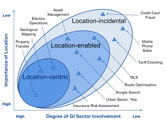
The definition of the geomatics sector adopted for the purposes of the study is “organizations involved in: geospatial information capture and processing; geospatial information analysis and presentation; integrated information products and services; location-based solutions; and geospatial information technologies”. The definition adopted for the geospatial information market is “the demand that exists for geospatial information (GI) products and services, including those that are location-centric (i.e., products or services that would not be possible without geographical location or position) and location-enabled (i.e., where geographical location or position is an important part of the delivery of products and services)”. The study scope does not include GI products or services that are location-incidental (i.e., where geographical location or position is not required for the delivery of products or services, but would be nice to have). The following figure illustrates examples of the types of products and services in each of these categories.
As indicated on the HAL project website – Canadian Geomatics Study – the community is being given a variety of opportunities to provide input to this important study. A cross-section of representatives of the GI supplier and user community are being consulted directly, selected user organizations are being analyzed through in-depth case studies, and electronic surveys will give the broader community the chance to influence the results of the study. Once the surveys are launched, HAL will be using a broad range of communications channels, including GI supplier and user associations, LinkedIn groups and GoGeomatics, to encourage people to complete a survey.
What does the study mean for the Canadian geomatics community? It will provide valuable input to the development of a Pan-Canadian Geomatics Strategy, a collaborative, open effort to develop a future vision, common goals and objectives for the community that is being undertaken by the Canadian Geomatics Community Round Table. It will provide solid information to clearly demonstrate to political and industry leaders the valuable role that the sector plays in helping to improve productivity in the Canadian economy. Finally, at a time when the geospatial information market is being transformed by collective technological, social, policy and business trends, and the very nature and constitution of the sector is being questioned, the study will provide the basis for reaffirming the sector’s identity and role as a major contributor to Canada’s future well-being and prosperity.
Please watch for the announcement of the study survey launch and take advantage of the opportunity to influence the future of the Canadian geomatics sector.


Ed:
Looks like a great study. I often wondered what kind of contribution Canada made to the geo-spatial world having been the pioneer in so many mapping applications.
Can I suggest that you also consider the importance of GI in the cybersecurity area? Location-based information is critical in the IT security world. Also, you don’t address the military and intelligence applications of GI, I guess outside the purpose of the study….although several Canadian companies do support the GI sector in these areas.
Jeff,
If you have any suggestions about who to consult in the cybersecurity area, please pass them along. Alternatively, when the online survey is launched you can alert your contacts in that sector and encourage them to respond. We are certainly addressing military and intelligence applications and have already consulted with DND and the RCMP, for example. Again, your help in encouraging Canadian companies that work in that area to provide input will be appreciated. Ed
Looks like a good initiative.