
When I heard about “Galileo HAS”, the first thing that came to mind was the great scientist, physicist, and astronomer Galileo Galilei. It has been nearly 400 years since Galileo Galilei studied celestial bodies and made extraordinary discoveries about planets and space using only the most basic of exploration tools.
We are all aware that GPS (Global Positioning System), the pioneer in establishing the Global Navigation Satellite System (GNSS), has played a pivotal role in the field of location intelligence and data-driven analysis for decades. GPS is to navigation what Xerox is to photocopying.
Today, we are surrounded by an array of satellite systems. In fact, now there are satellite systems from a number of countries. Satellite monitoring has become part of life, a business, and a rapidly evolving technological field. Ranging from the analysis of various natural disasters and predictions, climate variability, and civil unrest, satellite monitoring has always been one of the most accurate ways to achieve deeper insight.
Over years identify the pattern and put the right puzzle pieces in the solution.
We live in an age where visual representation guides our decision-making. Just like people prefer streaming videos to learn because our brains respond faster to visuals than text.
To come up with an innovative solution, we need good satellite imagery. Good satellites are necessary for good data.
Let me clarify myself. Here, I would like to put an emphasis on the horizontal and vertical positioning accuracy of the satellite system that can help us understand the bigger picture.
What if the accuracy comes down to merely a few centimeters? In this case, the less there is, the better.
“Galileo HAS” has done exactly that. On January 24, 2023, Europe’s first civilian Global Navigation Satellite System, which provides improved positioning and timing information, was put into service.
What is different about Galileo HAS?
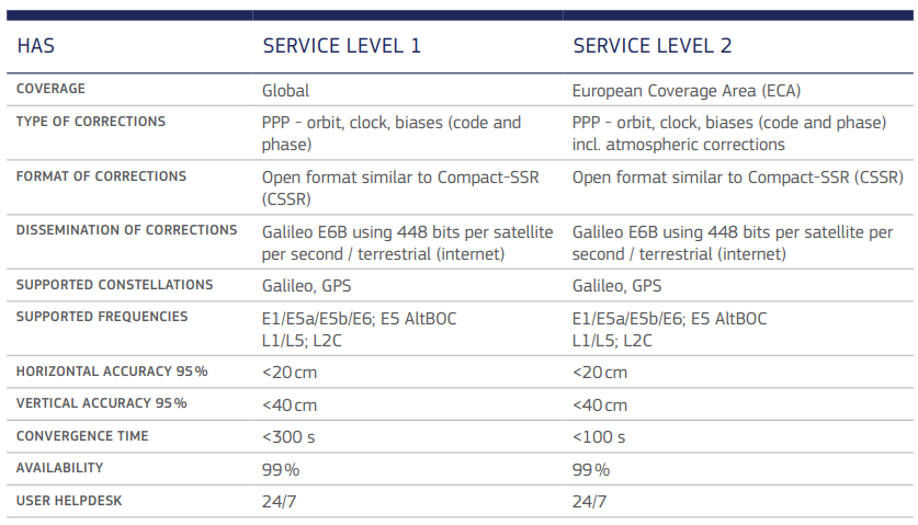
The Galileo High Accuracy Service (HAS) offers free access to the data that is needed to determine an enhanced positioning solution using a Precise Point Positioning algorithm in real-time, both through the Galileo signal (E6-B) and by terrestrial means (the Internet).
With the announcement of Galileo HAS Initial Service, users within the service area can benefit from improved user positioning performance in real-time.
The initial service of Galileo HAS provides the following information:
- Satellite orbit corrections to the broadcast ephemerides;
- Satellite clock corrections to the broadcast ephemerides;
- Satellite biases;
Users can experience fewer errors associated with the orbit and clocks via Galileo Open Service broadcast navigation messages and the GPS Standard Positioning Service that provides navigation data. Thanks to the precise corrections offered by the Galileo High Accuracy Service, when these adjustments are combined with the biases offered by the service and handled by the proper algorithm, a high-accuracy PVT solution can be computed in real-time.
Galileo supports multi-frequency and multi-constellation Galileo E1/E5a/E5b/E6 and GPS L1/L2C signals. An additional characteristic of the Galileo HAS service is the European Union’s (EU) Open Service Navigation Message Authentication, which has been planned to block hackers and other intruders from fabricating positioning data.
Reception of Galileo’s correction is possible using different approval methods:
- Galileo HAS SIS: Galileo HAS a signal in the space interface control document. This document gives detailed information about the signal correction through the Galileo E6 signal.
- Galileo has an Internet Data Distribution (IDD) interface. This one is based on the NTP protocol. You will need to register to get access to the interface.
Once Galileo HAS corrections are received, the user needs to implement the PPP algorithm to process the corrections and obtain a high-accuracy PVT solution.
How does Galileo HAS actually work?
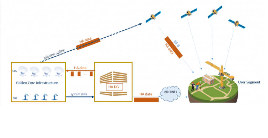
The infrastructure of Galileo HAS is organized into three segments: the space segment, ground segment, and user segment.
Space Segment:
Galileo’s space segment, known as the Walker constellation 24/3/1, consists of three orbital planes that can accommodate 24 official spacecraft in Medium Earth Orbit (MEO). The ascending nodes of the satellites are evenly spaced at 120-degree intervals, and they are 56 degrees off-center from the equator.
Ground Segment:
The Galileo ground segment comprises two main divisions: the Galileo Control Centers (GCC), located in Germany and Italy, and the Ground Mission Segment (GMS) and Ground Control Segment (GCS).
The GCS manages spacecraft maintenance and constellation upkeep through a network of globally distributed TT&C (telemetry, tracking, and control) stations. Its capabilities include planning and automation tasks that enable safe and proper operations, control and monitoring of the satellites and payload, and support for payload-related operations.
The GMS identifies the navigation and timing data parts of the navigation messages through the Galileo Sensor Stations (GSS) network. It communicates with the Galileo satellites via a network of ULS (uplink stations). Galileo Uplink Stations facilitate uplink and distribution of data to the Galileo constellation.
User Segment:
The Galileo user segment is composed of a wide range of compatible receivers and devices that collect Galileo signals in space and calculate their location. There are various types of users, depending on the application, such as transportation or timing apps. The horizontal accuracy of <20 cm and vertical accuracy of <40 cm invite numerous new and emerging applications to take advantage of the service.
Galileo HAS Blueprint
The execution of Galileo HAS has been laid out in the form of phases 0, 1, and 2. The figure below, provided by the European Union Agency for Space Program, is neat and precise.

After completion of testing activities and looking at individual details, Galileo HAS reached Phase 0, between 2020 and 2022, prior to publicly announcing its initial service.
Phase 1 was achieved when Galileo’s Initial Service was declared.
The progression of the services to reach their highest level of performance, which includes acquiescence with the SL1 performance goals, will mark the completion of Phase 2.
Who is going to benefit?
It is hard to find a sector that cannot benefit from Galileo HAS services. The evolving requirements for navigation, surveillance, and sustainability can be met with the help of satellite systems like Galileo HAS.
Galileo HAS services can play a crucial role in monitoring various modes of greenhouse gas emissions, accurately predicting climate changes, and developing adaptation and mitigation plans. The data provided by satellite systems can enable the creation of more informed climate forecasting models.
Sectors like railway transit and urban planning can greatly benefit from the advanced services offered by Galileo HAS. The provision of highly accurate positioning, navigation, and timing data can aid in the creation of smarter, better-connected, and climate-friendly cities.
Galileo HAS, with its potential for future upgrades, can serve as a vital component of the EU’s geospatial market, facilitating the development and delivery of smart and efficient operations in mission-critical control centers.
With endless possibilities, it is exciting to anticipate the advancements that will emerge as a result of Galileo HAS services. The integration of satellite technology in our lives offers endless technological surprises, and Galileo HAS is at the forefront of this cutting-edge technology.
References:
Crumley, B. Jan. 25th, 2023, EU launches Galileo’s High Accuracy Service positioning feed worldwide. Retrieved from https://dronedj.com/2023/01/25/eu-launches-galileos-high-accuracy-service-positioning-feed-worldwide/
European Union Agency for Space Program. Galileo High Accuracy Service (HAS). Retrieved from https://www.gsc-europa.eu/galileo/services/galileo-high-accuracy-service-has


Be the first to comment