
Indian Government starts work on mapping villages
The Indian government is using geospatial technology and drones to map six lakh villages and prepare 3D maps of 100 Indian cities. Space minister Jitendra Singh said, “the trinity of geospatial systems, drone policy and unlocking of the space sector will be the hallmark of India’s future economic progress.”

Read more here.
Scottish space sector charts path to a sustainable future
The industry-led group Space Scotland is developing a sustainability strategy for space. The roadmap will develop an approach that includes reducing emissions and mitigating space “junk”. The aim is to spur meaningful international action in such areas.

Read the article here.
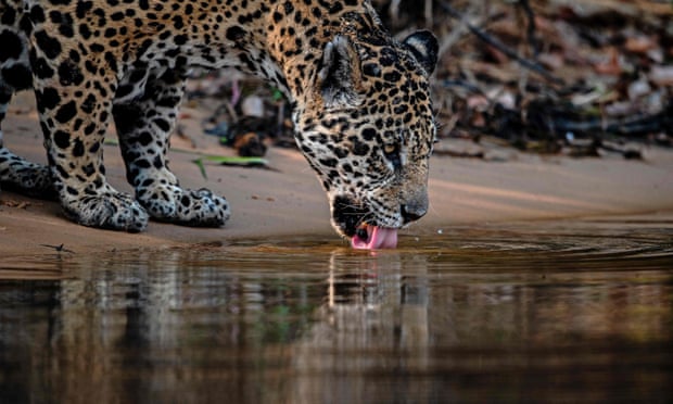
Five ways AI is saving wildlife
A recent report by Wildlabs.net has been identified artificial intelligence as one of the top three emerging technologies in conservation. Learn how AI is stopping poachers in Zambia, tracking water loss in Brazil, finding whales by sound signals, protecting koalas, and counting species in the Congo basin.
Read the article here.
Satellite images show military movements by Russia
Maxar Technologies was monitoring Russia’s military build-up along the border with Ukraine. The company released images of deployments of equipment and troops from Russian garrisons.

Read more here.
Underground Railroad secrets revealed with drones, lasers and radar
Archaeologists and historians have uncovered new insights about the Underground Railroad using GIS mapping, lidar, and magnetometry. Recent archaeological discoveries and new analyses are revealed in the new four-part docuseries “Underground Railroad: The Secret History,” which debuted Jan. 30 on the Science Channel.

Learn more at livescience.com.
NASA ‘NACHOS’ Instrument May Help Predict Volcanic Eruptions
The prototype instrument “Nanosat Atmospheric Chemistry Hyperspectral Observation System,” or NACHOS, will use a compact hyperspectral imager to locate sources of trace gases in areas as small as 0.4 square kilometers. NACHOS will be the smallest, highest resolution space-based instrument dedicated to monitoring atmospheric trace gases like sulfur dioxide (SO2) and nitrogen dioxide.

Read more here.

Be the first to comment