
President Biden has nominated Frank Whitworth to be the next director of the National Geospatial Intelligence Agency
Frank Whitworth is a US Navy Vice Adm and if he’s confirmed by the Senate, he’ll be the eighth director of the NGA. Currently, the position is held by Vice Adm. Robert Sharp, who has run the agency since February 2019.
Whitworth is currently serving as the director of intelligence for the Joint Chiefs of Staff at the Pentagon, and has had many positions as a commanding officer and director.
Read more here.
A new biomass mapping tool can pinpoint the carbon of a single 30 metre tree
This month, a new biomass mapping tool named Chloris was launched. It provides a net view of the planet’s AGB (aboveground biomass) and can show changes over the past 20 years. This was founded by Marco Albani and Dr Alessandro Baccini. Chloris can be used for a variety of projects including identifying carbon stock or risk monitoring.
So far, Chloris has been used to identify that France has the largest growing number of carbon sinks, while China has the largest ABG sink.
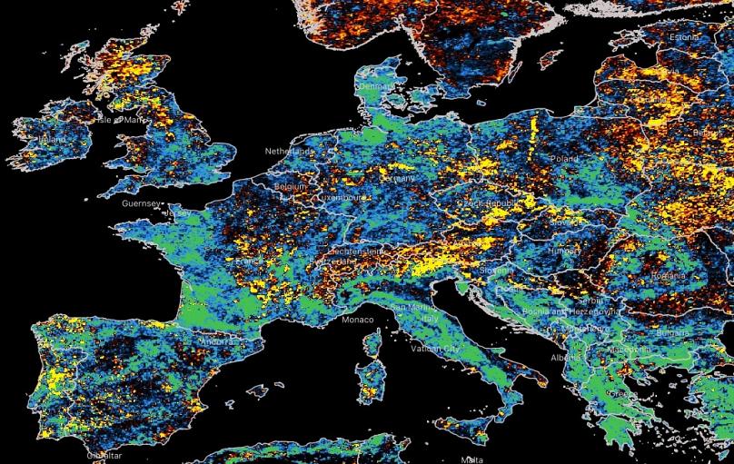
To learn more about Chloris and what it has revealed already, read the article here.
Microsoft announces Azure Orbital as part of Azure Space
Azure Space is a collection of products from Microsoft that provide satellite data and connectivity. The most recent addition to Azure Space is Azure Orbital. It provides communication and control of satellites and is partnered with a few other companies to give geospatial data as well.
Azure Orbital is a ground station so it will make managing challenges easier.
For more quotes from Microsoft and use cases, read here.
SpaceX Falcon 9 rocket ship launched over 100 satellites into space
On a mission called Transporter-3, the Falcon 9, a rocketship from SpaceX, launched on January 13th. The rideshare mission launched 105 satellites into space for orbit. And that’s not all the objectives of the mission, as some satellites were improved with better cameras and will serve in collecting agriculture and farm equipment data!

To learn more, read this article.
OGC approves new version of 3D streaming Community Standard, I3S
The Open Geospatial Consortium (OGC) Membership has approved version 1.2 of the OGC Community Standard Indexed 3D Scene Layer and Scene Layer Package Format Specification, aka the I3S.
The I3S allows for streaming large amounts of 3D geographic data and this enhanced version means more support for compression and usage by both experts as well as casual users.
For more info, read the official announcement here.


Be the first to comment