
Ground Temperatures Hit 118 Degrees in the Arctic Circle
During the recent heatwave in Siberia ground temperatures reached 118 degrees Fahrenheit (48 degrees Celsius) as seen by satellite imagery. The Copernicus Sentinel satellites were able to capture this rare weather event in in the town of Verkhojansk, located in Yakutia, Eastern Siberia. It is important to note here that ground temperature was observed and not air temperature which was recorded at 86 degrees Fahrenheit (30 degrees Celsius). The air temperature was significantly cooler than ground temperature, however, is still an anomaly for the region. Extreme ground temperatures cause melting of permafrost, this can negatively impact the region by destabilizing the earth causing landslides and can disturb building foundations. Melting permafrost can also release methane into the atmosphere that will further contribute to climate change.
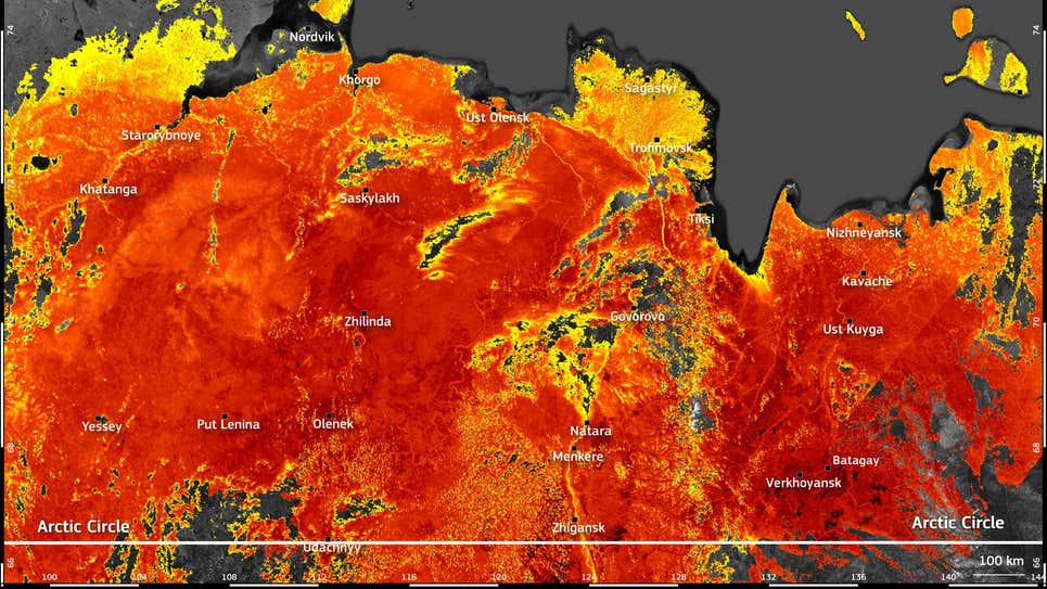
Photo Source: European Union, Copernicus Sentinel-3 imagery
Article can be viewed here.
NTIA Creates First Interactive Map to Help Public See the Digital Divide Across the Country
This digital map released by the U.S. Department of Commerce’s National Telecommunications and Information Administration (NTIA) shows broadband needs across the United States. This interactive map, which gathers both private and public data, is the first of its kind in which users can see regions in the United States without high quality internet access. The interactive map shows that the median internet speed in many areas in the country fall below 25 Mbps download and 3 Mbps upload.

Article can be viewed here.
Mapping quest edges past 20% of global ocean floor
The Nippon Foundation-GEBCO Seabed 2030 Project has come even closer to its goal of reaching 100% coverage by 2030. When the project started in 2017 only 6% of the ocean was mapped, now 20.6% of the depth and shape of the ocean floor has been measured using modern standards. One of the most significant recent contributors of this project is the DSSV Pressure Drop ship, that was able to map an area the size of France in just 10 months. Looking to the future, the article illustrates the importance of Uncrewed Surface Vessels (USVs) in accomplishing the Seabed 2030 target of 100% coverage by the end of the decade.

Article can be viewed here.
New space station antenna, satellites track bird migration
Researchers wanted to find out more about American robin’s migration patterns and why some travel exceptionally long distances while others simply do not. With the use of the International Space Station’s new antenna and the Argos satellite’s receptors, scientists can now more easily track migration patterns of songbirds. Technological advances, such as, decreasing size of tracking chips and batteries have made it possible to monitor such small birds. Those advances combined with the use of satellites have made it easier for scientists to gather higher quality and more precise data than they have before.

Article can be viewed here.
Morphometric analysis of Toshka Lakes in Egypt: A succinct review of geographic information systems & remote sensing based techniques
A new study was released that highlights the importance of Remote Sensing and Geographic information systems for monitoring hydrological changes. Researchers studied surface hydrological changes in Toshka Lakes in Egypt looking at elevation data using ArcGIS. The study found that integrating both Remote Sensing and Geographic Information Systems was an efficient way of monitoring hydrological changes and acquiring flood information.

The study can be viewed here.


Be the first to comment