
- A map depicting the imbalance between cultivation and biodiversity.
- Choronocard will help with GIS Analysis workflow
- 13 MILLION-mile network of worldwide highways have been mapped
- Use of remote sensing for Cadastral mapping and land registration
- New Geospatial Facility in the State of Montana, US
- Germany campaigns to attract young crowd toward Geospatial
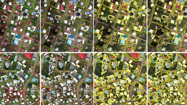
A map depicting the imbalance between cultivation and biodiversity
A study has found that the cultivation of staple crops occurs on high-priority conservation land in some parts of the world. This can result in biodiversity loss in that area.

Based on their importance for conservation, from lowest to highest, the multinational research team, which included individuals from Norway, the Netherlands, and Japan, categorized agricultural areas into four groups. The specific agricultural products that were produced at each of these priority levels were subsequently determined.
In order to determine the conservation value of various locations, the study examines 50 agricultural products sourced from 200 nations and makes use of farming data, a database of global supply chains, and new ecological models with conservation data for more than 7,000 species. To know more about this news and the interactive map, click here.
Choronocard will help with GIS Analysis workflow
Chronocards, created by Mike Davlantes, is a tool for GIS that could potentially save analysts tonnes of time and effort by logging GIS workflow, documentation, and reporting tools for ArcGIS Pro. This helps with a better-managed GIS workflow.

Available as an add-in for ArcGIS Pro, Chronocards can connect to a cloud-based or on-premise software application. From logging in metadata about a team’s work in ArcGIS Pro and streaming it in real-time to a web dashboard, it has the ability to remember universal knowledge to recreate geospatial analysis in case nothing has been written down. This new tool will aid in recreating “best practice” workflows by cherry-picking the best pieces of a normal workflow that has passed lots of trial and error. To know more about this tool click here
13 MILLION-mile network of worldwide highways have been mapped
Not too long ago, we used to stop our cars and ask the pedestrian about the right direction.

Adam Symington from PythonMaps has mapped each and every road, be it a highway or a local road, secondary or tertiary road. Not just for one city but for all the countries on the planet. The map above shows how world-wide-web of roads has been portrayed.
Using information from the Global Roads Inventory Project (GRIP), he has provided the most accurate representation of connectivity on land. Find out more about these incredible maps here
Use of remote sensing for Cadastral mapping and land registration
Innovative methods for land administration and management, such as automatic image orientation, surface reconstruction, scene analysis, change detection, classification, and automatic feature extraction with the help of artificial intelligence, spatial statistics, and machine learning, are being developed.
Utilizing the advances of remote sensing and geospatial information science, such as unmanned aerial vehicles (UAVs or ‘drones’), satellite and airborne-based sensors, as well as Lidar, all with high spatial, spectral, radiometric, and temporal resolutions, solutions are being developed to support fit-for-purpose land administration. Read more on this here
New Geospatial Facility in the State of Montana, US
The Geospatial Core Facility’s (GCF) goal is to develop GIS capabilities across MSU and outside of the university.
GCF will provide campus researchers with access to the latest equipment, such as drones, sensors, software, and computational technology, along with proficiency in geospatial technologies and analysis. Also, members of the GCF team intend to enhance science by collaborating as co-investigators on projects that consist of geospatial components or by designing maps and graphs.
The current projects summary is as follows:-
- Examining ways to provide shade over streams to enhance stream health.
- Conceiving strategies to keep open space in Bozeman over the ensuing 10, 30, or 50 years.
- Constructing a website that compiles stream and river data from western states into a GIS portal to deliver real-time details on streamflow, Stream closures, and governmental limitations.
- Collecting in-depth information about crop and field properties, such as soil moisture and nutrients, using drones. Read more on this new facility here
Germany campaigns to attract young crowd toward Geospatial
The German Association for Geodesy (DVW) has initiated a campaign to create awareness among young people about the exciting career opportunities in the geospatial industry.
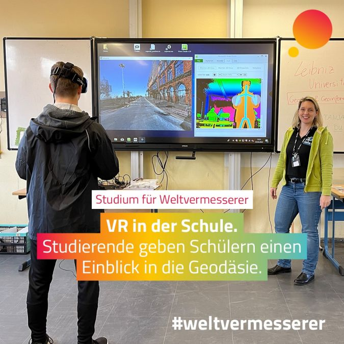
Like many countries, Germany is struggling to find people in the field of geodesy as the number of vacant positions exceeds the number of available experts. Universities and other organizations in the geospatial sector have historically had a difficult time connecting with and grabbing the interest of young people between the ages of 14 and 19. In order to best appeal to this target population, the campaign’s developers realized they needed to combine all present online activities and initiatives run by the many groups, universities, networks, and collaborating partners. Read about this here


Be the first to comment