
“Oh the Places You will go!” Part 2: Continuing the “COGServation“
Everything is connected to everything else!
I recently wrote an article for GoGeomatics on Ken Bragg of Safe Software.
In the course of our conversation when Ken said he had attended COGS, I asked if he knew Dave MacLean. It turns out that he graduated before Dave started teaching, but that he had heard of him.
For years, I have interacted with geospatialists in education, government, and industry from across Canada and from around the world at conferences, meetings, and on social media. A good number of them knew about (or asked if I knew) Dave MacLean at COGS, so it was natural to infer that Dave and COGS are synonymous.
As with all COGS’ faculty, Dave is well-revered in geomatics and education circles in Nova Scotia, and all have had the privilege to influence a great number of students. Those graduates have gone on to wonderful, fulfilling careers.
In time, I met Jon Murphy from Ottawa of GoGeomatics through the Royal Canadian Geographical Society of which we are both Fellows. Jon later connected me with Ted MacKinnon. Sure enough, Jon and Ted had gone to COGS. They both knew Dave MacLean too, through COGS and GANS. https://gans.ca/. Turns out that Ted and Dave are both Fellows, too. More connections!
As an educator, one of my favourite quotes is, “A teacher affects the future.” Therefore, I could only conclude that Dave, as an instructor and role model, has been influential in mentoring countless students, leaving a valued legacy to his profession.
Dave has had many positions in geomatics on his trajectory to COGS:
- GIS Specialist for J.D. Irving, Ltd., NB
- GIS Applications Administrator at the Centre for GIS, Doha, Qatar
- GIS Developer for Industrial Forest Service, Ltd. and Spatial Mapping Ltd., Prince George, BC
You can read an article about Dave here:
I soon encountered Dave on cyberspace (Twitter). We were both following Canadian astronaut, Chris Hadfield, (@Cmdr_Hadfield). Commander Hadfield was on the ISS from 19 December, 2012, until 13 May, 2013. Commander Hadfield’s famed social media presence on Twitter grew, especially his daily photos, which he shared freely on Twitter.
Chris Hadfield had the ultimate geospatial perspective.
So (@DaveAtCOGS) is best known to me for the stellar company he keeps. His way of being known among geospatialists came about during Commander Chris Hadfield’s time on the International Space Station. (Yes, geospatialists love space too! Pun intended!)
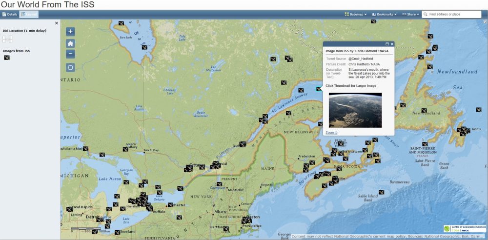
Dave downloaded the photos from space and integrated them into a map, which was the ultimate combination for geogeeks everywhere obsessed with location:
A Canadian portion of these were manipulated by Esri Canada into a story map: “Maps are here” I love #27!
Here is Dave’s recollection of the creation of his Storymap:
Peggy: How did you get the idea?
Dave MacLean: In early January 2013, I (like so many others) noticed the incredible pictures of Earth that Canadian astronaut Chris Hadfield was tweeting. I realised two things: (1) a map could provide an ongoing spatial context for these pictures; (2) creating this map could result in a great online mapping example for my classes!
Peggy: What was the length of time to create the map?
Dave MacLean: The technology combines (1) a Google form resulting in (2) an online CSV. That is consumed by (3) an Esri ArcGIS Online map. The map production (basemap, popup, testing) took about an afternoon. Each data point took a few minutes (to enter tweet URL, tweet text, and latitude & longitude for that map- pin). Updates appear automatically for anyone using the map.
Peggy: What sort of responses did you have?
Dave MacLean: A great set of positive responses; sometimes there was a polite correction or a question about clarifying a picture or tweet. This project led to a map (with a different map style) for the next ISS mission, and then another. Now, there are a number of maps with different capabilities and styles providing context for each mission and numerous examples for students.
Peggy: What was the scope of success i.e., publicity)?
Dave MacLean: There were many interviews and articles by radio stations and newspapers, and numerous requests to do specific maps by other astronauts. Actually, it was great to receive all the positive feedback.
Peggy: Were there any negatives?
Dave MacLean: None. People really liked the app and the ability to connect the pictures with their actual earthly locations. These kinds of connections help people to see the world from different perspectives, and this can be illuminating.
Peggy: Did you ever meet with or talk to Chris Hadfield?

Dave MacLean: Recognizing Chris’s contribution to spreading information about geography, NSCC-COGS granted him an Honorary Diploma. He Skyped in to our 2013 graduation exercise and spoke directly to the grads. I had the privilege of delivering the actual diploma to him & having a conversation.
Peggy: What has been the most interesting aspect of your career?
Dave MacLean: People: meeting them, working with them, talking with them- especially when there is a geographic aspect to the conversation or when it’s a discussion with grads about “what they are doing” or one of their recent projects. So many people in the geo-community are simply trying to make the world a better place.
Peggy: In what other ventures as a professional are you involved?
Dave MacLean: I work with the Geomatics Association of Nova Scotia (https://gans.ca), volunteer as a GIS Ambassador and co-ordinate activities for COGS students involved in the Esri Canada Centres of Excellence program.
Peggy: What general advice do you have for those just starting their career?
Dave MacLean: Attend networking events, conferences, & functions; try new technologies; learn lots; connect with your local geo-community!
Wow, wow, wow!! Dave got to actually meet Chris Hadfield! And…to present him with his diploma! All because of his career. The geogeek in me thinks that is pretty awesome!
But, I was more deeply impressed by these statements of Dave’s, which allude to the difference he has made:
“This project led to a map (with a different map style) for the next ISS mission, and then another. Now, there are a number of maps with different capabilities and styles providing context for each mission and numerous examples for students.”
“…and numerous requests to do specific maps by other astronauts.”
Think about my statement, “A teacher affects the future”. Dave MacLean’s expertise and idea led to a resource for everyone, but his first goal, as an educator was to create something for his students.
My takeaway from Dave’s responses is to never stop learning, CONNECT in whatever way you can and give back to the community by sharing your expertise. I’m confident in saying that we all appreciate Dave’s inspirational contribution. Great things originate at COGS!
Sometimes a career path may be difficult. Go where the job takes you. Enhance yourself every chance you get. Lastly, never stop exploring all things geospatial! Now, back to Dave’s storymap……!
Coming soon: Part 3 in the COGServation.


Be the first to comment