
GoGeomatics Canada interviewed Steve Minnie, the Regional Director and Deputy Surveyor General of Canada and we’re sharing our enlightening discussion with the community.
The topic we’re discussing is the Survey Capacity Development Program currently underway by the Surveyor General Branch (SGB) of NRCan in First Nations communities across Canada. The program was initially started in 2018 with the goal of establishing relations and conveying knowledge about land surveying and important skills within a flexible and practical learning framework.
Program Goals
The program strives to create positive relationships between First Nations communities, the Canadian government, and land surveyors through the spread of knowledge. Participants in the program gain an awareness of what land surveying is and access to training that allows people within the First Nations community to participate in surveys, communicate their needs to surveyors more effectively and better assess the services they receive. The SGB is also hoping to increase interest in the field of geomatics and science within these communities.
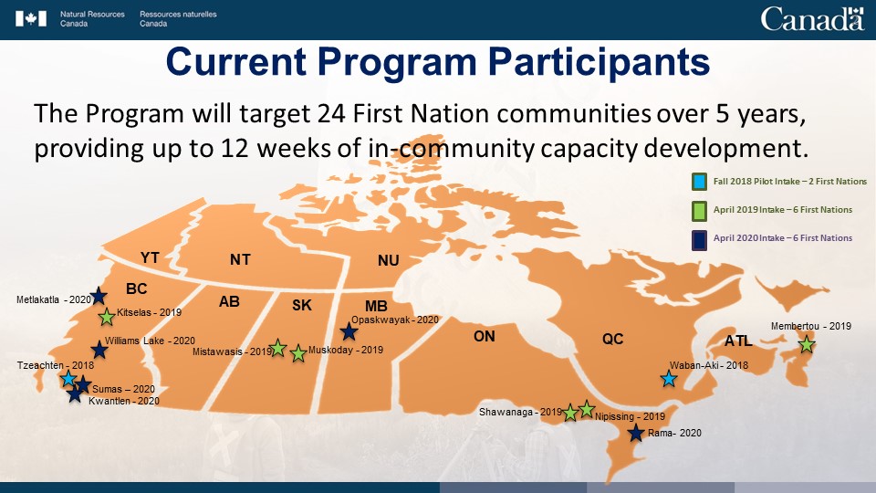
As of April 2020, the program has targeted 14 First Nations communities across Canada with more on the way:
Steve Minnie, the Regional Director and Deputy Surveyor General of Canada
Steve Minnie is a licensed deputy land surveyor with the SGB who has been surveying for over 30 years. He is based out of British Columbia and his office is responsible for overseeing the region of Western Canada. He began his surveying career in 1982 as a summer job in small town eastern Ontario. He enjoyed his experience so much that he ended up pursuing it as a career, graduating from the University of Toronto in 1988 with a Bachelor of Science in Survey Science. He became an Ontario Land Surveyor in 1991, and joined the Surveyor General Branch of Natural Resources Canada in 2000. He became the manager of the BC Regional Office in 2006 and was appointed as the Deputy Surveyor General for all of western Canada in 2016.
For more information on the program, please have a look at this presentation that was kindly supplied by NRCan:
[slideshare id=239729007&doc=sgb-surveycapacitydevelopment-presentationtosgbscienceforum-fredericton-september9-102019-en-201203211705&w=650&h=500]
It provides a comprehensive overview of the program, it’s goals and other important details.


Be the first to comment