
Lawrie Keillor-Faulkner: GIS Instructor, Fleming College
 GoGeomatics Canada is talking to Lawrie Keillor-Faulkner a member of the GIS Faculty at Fleming College in Ontario.
GoGeomatics: Welcome to the GoGeomatics Canada community. To get started can you tell us about where you are from and how you decided to make a career of GIS? Where did you get your geomatics education?
Lawrie Keillor-Faulkner: I grew up in the west end of Ottawa, Ontario. I always liked Geography in school – I remember making a map in Grade 9 or 10 and using some pretty funky patterns because I had more countries to fill in than coloured pencils. I know my geography teacher thought it was pretty psychedelic, but I was quite proud of it.
In my early twenties I took a Canadian Pacific train across Canada and travelled around out west for three years. I ended up working and living in Banff, AB and Vancouver, BC for a few years; some of the best years of my life. During my travels I kept a map and marked the places I had visited so I could see where I had been: for e.g. how far west or how far north (FYI: Tofino, and McBride, BC). I’ve also been to Newfoundland so I’ve been to both Atlantic and Pacific coasts. I’ve yet to make it up to the Arctic but it is definitely on my Bucket List.
When I returned to Ottawa I decided to go back to school: I knew I had a brain and I wanted to use it. I didn’t have a lot of money and because I liked maps I looked into Algonquin College and started their Cartographic Technician program. I graduated from the Photogrammetry Option of that program in 1984—I like the math and the stereo-imagery involved in photogrammetry. A lot of people in my family like maps (and math) too; my grandmother was an excellent artist and my cousins are engineers or scientists, so cartography as an art and a science really worked for me.
GoGeomatics: What was your first job in geomatics?
Lawrie Keillor-Faulkner: One of my photogrammetry teachers, Ron Miller, worked at McElhanney Surveying and Mapping, and he liked my work and recommended me. This company is based out west, but had an Ottawa office at the time I graduated. I worked there making maps as a photogrammetrist/stereoplotter operator for over a year. I enjoyed that first job a lot. My co-workers were all men so I used to bone up on my hockey and football scores, so I could join in the coffee discussions in the morning! The job was shift work and every second week I had to either start at 7:00 a.m. or 3:00 p.m. I enjoyed the free mornings on the late shift, but getting up for 7 a.m. was really hard! I loved making maps with the stereomodels and I still love seeing the world’s relief and morphology in 3D. I love the visual component of cartography and GIS.
I mapped many places in Ontario, for example Hearst, Long Lac and Niagara Falls for the Ontario Base Mapping (OBM) series, but we also had contracts in Nova Scotia, and CIDA contracts for Zimbabwe and Lagos, Nigeria. I’ve never been to Africa but I’ve mapped it. I used to say that the contours of Zimbabwe were so beautiful they would make great wallpaper. My husband Hamlyn spent some time in Hurare, Zimbabwe during the late ‘80s (before I met him) and while I’d still love to go there too some time, it is very far away and the political situation there is very volatile.
GoGeomatics: How would you describe you geomatics career so far? Can you tell us how you got to be where you are now as GIS instructor in Ontario?
Lawrie Keillor-Faulkner: From McElhanney, I went down east to Summerside, PEI for two years, and made maps at the Council of Maritime Premiers, Land Registration Information System (LRIS). While there I learned to my surprise that I was both an ‘Upper Canadian’ and ‘from away’. My job was usually shift work there too, but at least it was a two-week cycle, instead of changing every week.
I learned a lot about the mapping world while there. I was invited to try a number of different job positions, including bridging (aerotriangulation), pugging (marking control points on blocks of photography) and digital editing (QA/QC), etc. They used the Canadian mapping and hydrologic software CARIS, which I believe was developed through UNB. I was the first woman to do bridging and as a rookie, I guess my work must have been pretty good for them to let me do these jobs, as they are very important in the accuracy of the mapping. I especially enjoyed the outdoor field checking work in New Brunswick. In 2004, my husband and I drove down to PEI to attend an LRIS reunion and it was great to see so many of my old co-workers. I still keep in touch with a number of my Maritime friends and colleagues through Christmas cards and Facebook.
After a couple of years down east, I moved to Toronto and worked for a great company, Bennet and Norgrove, Surveyors and Mappers. I worked primarily as photogrammetrist again, but I also branched out into more digital editing and learned to use MicroStation software. I was also sent out surveying, when the mapping contracts were slow, and again, I really enjoyed the outdoor work. I was lucky enough to be on a crew with another woman, although the crew chief was a man, as is still usual in the surveying industry. They were both great folks and we had a lot of laughs out surveying.
Being in the Greater Toronto Area (GTA), the surveying was a lot of housing subdivision work, especially in Mississauga. I remember one time I got stuck in the mud, my heavy steel-toed boot came off and I was laughing so hard I couldn’t move. I’ve often wondered how accurate that particular survey ended up.
Eventually I returned to Ottawa (again) and once again worked for McElhanney (now GeoSurveys) for another year. When I met my to-be-husband in 1990, Ham Faulkner, he was a Forestry Professor at Fleming College’s Frost Campus in Lindsay, Ontario and I moved to the Kawarthas area to be with him. My mother is from this area, so it has often felt like fate that I should end up here.
There were no photogrammetry or cartography jobs in this area, so in ’91, I went back to school and took Geography and Environmental Studies at Trent University in Peterborough. I won a few awards while at Trent, including one for cartophilia, the love of Maps; my report was entitled “Maps help to tell the Story”, and they do! I still love looking at and working with maps.
While at Trent, I took advantage of the Trent University-Fleming College agreement where the GIS-Application Specialist (GIS-AS) graduate certificate program at Fleming counts as a year toward an honours Bachelors degree at Trent. Fleming’s excellent program is extremely intensive and well respected in the GIS and geomatics industries. I graduated Fleming in 1994 and from Trent in 1996 with a major in Geography: B.Sc. (Honours) with an Emphasis in GIS. I won an award for my thesis from the Royal Canadian Geographic Society: “Channel Head Initiation: Source areas and Slope Analysis using the Global Positioning System and a Geographic Information System, Ganaraska Watershed, Ontario”. My excellent thesis advisors were Professors Jim Buttle and Cheryl McKenna-Neuman, and I believe mine is the first thesis that used GPS at Trent.
I really believe in the combination of college and university. I often tell my students: you get the hands-on skills at college, as well as analytical and research skills from university. It was all a great experience for me and I thank all my professors at both institutions, as well as my husband who was a huge supporter of mine.
I have worked part-time a few times at the Ontario Ministry of Natural Resources and really enjoyed my contracts with them. OMNR has their head office in Peterborough which is quite close to Lindsay, so we have a great working relationship with them. I’ve worked with the Surveyor-General’s office and as a beta tester for NRVIS (Natural Resource Values Inventory System). I suggested they call it SRVIS (for Spatial Resource Values Inventory System) but they didn’t take me up on it. I also enjoyed a mini-sabbatical with the Water Resources Information Project (WRIP); it is a great group of people, including mostly Fleming GIS and Cartography grads.
I’ve been working at Fleming College since I was a student and lab technician here. I started teaching in 1996 in a Common Semester technician level course called ‘Mapping and Geographic Systems’, which covered basic mapping concepts like drafting, scale and UTM. This course has since morphed into an introductory Geomatics, GPS and digital mapping course called ‘Geospatial Techniques’.
I love teaching this course and was lucky to have a mentor like my friend Janet Millard, who taught it for years before me and also had a Lindsay-Ottawa connection. Janet retired just last year and I still miss her around here. I have been full-time faculty since 1998 and coordinating either the GIS Specialist or Geomatics Technician (GMT) programs since around 2002 or ’03. I have taught lots of courses around here over the years including ‘Technical Issues in GIS’ and ‘GIS Applications’; some courses you just love teaching. ‘Geomatics in Surveying’ and the GIS Specialist Survey Camp and GMT Field Camp are fun because of the outside field work.
GoGeomatics: Can you tell us a little about the history of the GIS program at your school?
Lawrie Keillor-Faulkner: This portion of the interview is modified from an article I wrote a while back for Geomatica.
Fleming currently has three Geomatics and GIS programs: the entry-level Geomatics Technician program and two post-diploma Graduate Certificate programs, Geographic Information Systems Application Specialist and Geographic Information Systems Cartographic Specialist. I currently coordinate these last two programs.
The first of its kind in Ontario, the Geomatics Technician two-year diploma program is designed for high school graduates and combines the disciplines of Geographic Information Systems (GIS), remote sensing, surveying/GPS, and Cartography. The program focuses on geographic data collection, interpretation, presentation and dissemination. Graduates from this program receive advanced standing in the GIS Specialist programs. (Unfortunately, Geomatics Technician is currently going through some restructuring and will not be accepting students this September. We hope to offer a new version of this entry-level geomatics training soon.)
Fleming was the first college to offer GIS training in Ontario, and has been doing so for going on 25 years – all other college GIS programs were established later. We’re constantly upgrading and changing our GIS Specialists programs to suit the current and future demands of the field. For instance, a few years ago we revised the curriculum to add new courses in remote sensing, web applications and Global Positioning Systems (GPS) for spatial data. We have also added a GIS Survey Camp in the spring, which the students really enjoy as a bonding experience and a break from working in front of computers.
Graduates of this program receive an Ontario College Graduate Certificate – a credential that recognizes the comprehensive and advanced level of study required in this program. The jewel in the crown of the GIS Specialist programs is the GIS Co-operative Project undertaken by groups of students during the final two semesters of the academic year (January to June). During the January to April semester, the students choose a project and write their project proposal. Supplied by the GIS industry, municipalities and government clients, Co-op projects are completed during May and June. The Co-op project course is designed to be a learning and working experience for the students where they apply the many skills they have learned. Projects that the students undertake may include data acquisition/pre-processing, database design/processing, spatial and statistical analysis, programming, web technology and cartographic presentation.
This program is very intensive, the workload is heavy and expectations are high. Students tell me they thought they worked hard in university or college before they came here, but it was nothing compared to Fleming’s GIS Specialist programs. It is a real investment in their futures as many of our students are employed as soon as, or even before, they graduate.
GoGeomatics: What makes an excellent GIS program? How do you, as a GIS instructor, make sure that what you are teaching to GIS students is giving them the skills they need for the work force?
Lawrie Keillor-Faulkner: Regular program reviews are a standard part of all our academic programs here at Fleming College and we meet semi-annually with our GIS Specialist Advisory Board (professional members of the GIS/Geomatics community). I receive many job postings and forward them on to our faculty, students and career educators. In these ways, we keep on top of what current industry trends and employer needs and ensure we present these to our students. Industry also partners with us in our Cooperative GIS projects and is usually extremely happy with the calibre of our graduates. I will speak about this again a bit later.
Our teachers are first class and a number of us are coming from industry; photogrammetry, surveying, hydrological survey and MNR. We have an excellent understanding with MNR and some of our part-time teachers are also MNR employees, and some of our past teachers have moved on to work with MNR. In particular, I am proud to recognize Karen Whillans for winning the 2012 Charles E. Pascal Award for Teaching. Karen teaches the ‘Problem Solving and Programming’ courses at both the GIS and Geomatics Technician level. These courses have very difficult concepts and while she doesn’t make it easy, she is always ready to help. Karen is possibly the best teacher at this school.
GoGeomatics: In terms of GIS concepts what are the most difficult items to teach?
Lawrie Keillor-Faulkner: As I said previously, programming is probably the most difficult to teach, followed perhaps by topology and spatial statistics. Just planning and understanding the many logical steps required in a GIS analysis model can be difficult. Many students struggle with these concepts.
GoGeomatics: Can you give us some real examples of how your teaching achieves this? Do you have any assignments you could share with GoGeomatics?
Lawrie Keillor-Faulkner: You’ll have to come to Fleming College for this, LOL.
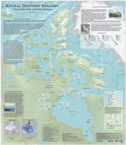
As we are the School of Environmental and Natural Resource Sciences, a lot of our assignments have natural resource or environmental applications. For example, one of our part-time teachers, Frank Kenny of the Water Resources Information Group at MNR, did a sabbatical with the UN-FAO in Sierra Leone. Following this, GIS Specialists in their Co-op projects and Geomatics Technicians in their fourth semester GIS lab work, have created a methodology for digitizing (and editing) the blue line water network from scanned Mr Sid maps in order to create a digital database of the Sierra Leone hydrology. The GMT students are marked on their positional and attribute accuracy, as well as the topology of the hydrological geodatabase. I am so very proud of this global community relationship.
GoGeomatics: What are you looking for in a GIS student?
Lawrie Keillor-Faulkner: I really enjoy getting to know our GIS Specialist students: they are a real diverse group; smart, hard-working, spatially oriented and map loving, logical, yet innovative and lateral thinkers. They are mostly university grads (about 90% of them) with a background in Geography or Environmental Studies. We also receive students with college and other university backgrounds, but we find those who have already taken some GIS do better in our very intensive program.
GoGeomatics: Do you have any student portfolios that you would like to share with us? Some that might give other potential students an idea of what to expect if they were to come to work with you?
Lawrie Keillor-Faulkner: These are some portfolios available at the following links:
http://flemingcollege.ca/geomatics-at-fleming/student_projects/index.html
http://flemingcollege.ca/geomatics-at-fleming/?a=geomatics-at-fleming
http://www.gogeomatics.ca/meghan_miller
GoGeomatics: What makes the GIS program at Fleming stand out from all the other programs out there?
Lawrie Keillor-Faulkner: As I said, Fleming was the first college to offer GIS training in Ontario, and has been doing so for over 24 years. The GIS industry knows our name: graduates of Fleming’s cartographic programs have earned a reputation for excellence through their achievements in the workplace, and through cartographic and GIS competitions. Over the years, they have captured 80 American Congress on Surveying and Mapping awards in annual competitions (student category), as well as numerous awards from the Canadian Cartographic Association and the Canadian Institute of Geomatics. Graduate employment rates remain high and Fleming’s reputation in the GIS industry remains unequalled.
Our Cooperative Projects are outstanding and innovative. Clients ‘hire’ our students to figure out projects, analysis and problems they don’t have time or resources to do themselves. Please check out our past and current projects at: http://www.geocommunity.net/
I like clicking on the Bid Matrix to see what is happening right now with the projects.
GoGeomatics: What are the job prospects like out there for graduates of your program?
Lawrie Keillor-Faulkner: Job prospects for GIS and Geomatics Technicians are very good. As I said earlier, many of our students are employed before they even graduate and most are employed in related fields within six months of graduation. Recently employers from Esri in Redlands, California, EsriCanada and Intergraph Canada have interviewed our students for various GIS technical positions. The interviewers were very impressed with the calibre of student and their education and have hired a number of our graduating class. AECOM has also recently hired a number of our students and prefer to hire Fleming grads over other schools. We are known as a prestigious school for GIS and I am very proud of that.
GoGeomatics would like to extend our thanks to Lawrie for taking the time to introduce us to Fleming College.


This is fascinating to read about your experiences and background in the field, Lawrie. I only had glimpses of what you had done since Carleton so hearty congratulations on what you have accomplished.
I just love to read stories like this where someone follows their interests even if means ‘uncharted’ territory! Way to go Lawrie.
Thank you for sharing this very informative blog Geographic Information System.