
Location Encoding Systems – Could geographic coordinates be replaced and at what cost?
Geocoding is the process of converting a street address into a physical location that can be described with a pair of geographic coordinates. It is estimated that over 40% of the world population is physically disconnected because of lack of a street address. But even when street addresses are available, they are very often unable to describe the location. For example, locations inside parks or large facilities (e.g., stadiums or hospitals with multiple entrances) may be hundreds of meters away from the nearest address. The use of directions (such as “behind the main building find a storehouse; deliver the package at the right door facing the park”) instead of an address has become a common practice. However, this is usually ambiguous as it relies on local knowledge, while it cannot be interpreted automatically.
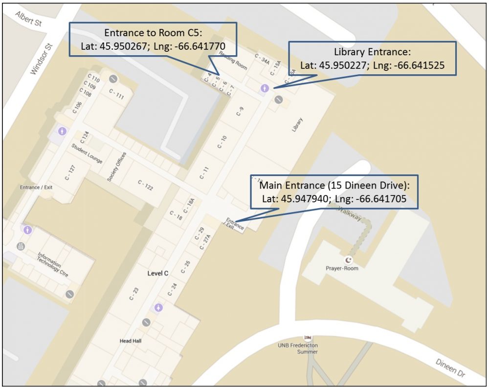
Figure 1. UNB Campus. Three locations in Faculty of Engineering building. The street address to all of them is that of the Main Entrance: 15 Dineen Drive, Fredericton, NB
The wide spread of smartphones and mobile devices on one hand, and the extended internet accessibility on the other, have brought back the problem of geocoding in geomatics research and development. A geographic point location described by numbers (coordinates) – the geographic latitude and longitude as well as the height or depth – can be found more easily than ever by most of the users (as the smartphone becomes default equipment; I still resist and don’t have one!).
ISO 6709:2008 is the geocoding system that offers a standardized representation of geographic point location by coordinates [1]. This system may describe any location on the earth surface and the surrounding area at any resolution or zoom level.
However, it is argued that geographic coordinates are difficult to remember. In addition, a pair of latitude, longitude refers to a specific point in space regardless the number of decimal digits used to describe them. By truncating the decimal digits of geographic coordinates, a new location is defined. This way, geographic coordinates fail to explicitly define an area in space with a size that varies depending on the resolution.
The last couple of years there is a significant interest in the development of alternative location encoding systems to better support specific geomatics applications, including navigation in space (directions). Two popular systems, introduced recently, are: Google’s Open Location Code (OLC) [2] and what3words (w3w) [3]. Those systems are added to an already long list of other geocoding systems [4], such as Geohash, Geotude, c-Squares, MapCode, Open Post Code, WMO squares, UTM grid, to name a few.
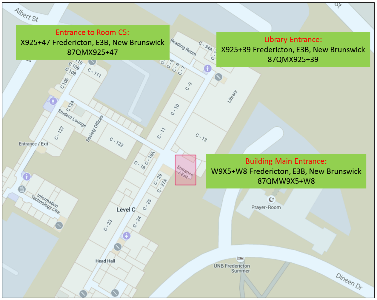
Figure 2. Open Location Code (OLC) encoding. The three locations in Faculty of Engineering building (Figure 1) are contained in areas assigned unique 10-character codes. Each area corresponds to approx. 14mx14m. https://plus.codes/87QMW9X5+W8
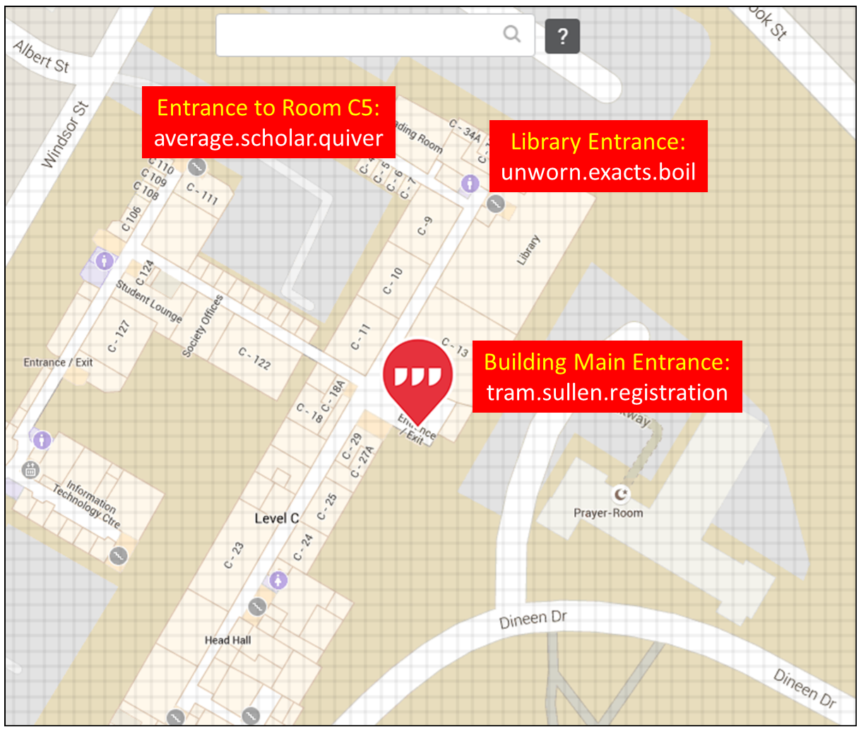
Figure 3. what3words (w3w) encoding. Grid cells are 3mx3m large. The three locations in Faculty of Engineering building (Figure 1) are contained in cells assigned unique 3-word codes. https://map.what3words.com/tram.sullen.registration
A Location Encoding System (a.k.a. geocoding system) is a scheme that assigns systematic alphanumeric labels to geographic locations or entities. Location Encoding Systems can be grouped into two categories: (a) those that convert geographic coordinates of point locations (latitude and longitude) into codes using an encoding scheme (e.g., Geohash), and (b) those that partition the earth surface and assign codes to the tiles generated by this partition. In the latter category, the tiles are encoded using an algorithm that calculates the alphanumeric strings and avoids recognizable words (e.g., Open Location Code), or the tiles are assigned one or more recognizable words from the English or other dictionary (e.g., what3words).
In addition, some geocoding systems support a multi-resolution scheme and encode smaller or larger tiles (areas) with more or less digits in a code (e.g., Geohash, Open Location Code), while others follow a constant tile size and equal-sized codes (e.g., what3words, WMO squares, UTM grid).
Existing Location Encoding Systems have been designed to support specific needs, hence their attributes vary accordingly. Location Encoding Systems designed to support navigation (directions), such as OLC and w3w, are able to describe any location on earth with a short code. Users can enter this code in their phone, tablet, or laptop, and get the exact location. They do not even need to be online. An application running on their devices can support navigation to the destination.
The desired attributes for a Location Encoding System to support navigation are [5]: (a) a code should be short, easy to memorize, sufficient on its own, and unique for each place; (b) a code should not include easily confused characters (e.g., 8 and B, 1 and l) or a preference to any language or (even) alphabet; (c) codes should represent an area in multiple resolutions with variable number of digits (shortening a code should represent a larger area containing the same location); (d) a comparison of two codes should offer information about the spatial relation (topological, distance, or direction) between the corresponding locations or areas; (e) codes should be static, generated and decoded offline, independent on any one provider, and free to use.
Each Location Encoding System meets these attributes in higher or lower degree, and no system can outperform the others. Depending on the application needs, a system is preferable that another. For example, OLC supports multi-resolution representation and the extraction of spatial relations between two codes, while w3w does not (all tiles are equal-sized: 3mx3m and two codes cannot be compared to extract spatial relations). On the other hand, w3w provides codes that are easy to memorize; it can also support multiple languages. OLC uses Latin characters and as a result it fails to be language or culturally independent as claimed [6]. Neither system considers the third dimension; this is certainly an extension to expect in the future. Overall, geographic coordinates are too hard to remember, but get them replaced has always its cost.
References
[1] ISO 6709:2008, http://www.iso.org/iso/catalogue_detail?csnumber=39242 [Visited on Feb. 19, 2016]
[2] Open Location Code (OLC) http://openlocationcode.com/ [Visited on Feb. 19, 2016]
[3] what3words (w3w) https://what3words.com/ [Visited on Feb. 19, 2016]
[4] List of Geocoding Systems, Wikipedia https://en.wikipedia.org/wiki/List_of_geocoding_systems [Visited on Feb. 19, 2016]
[5] Rinckes, D., 2015. An Evaluation of Location Encoding Systems. https://github.com/google/open-location-code/blob/master/docs/comparison.adoc [Visited on Feb. 19, 2016]
[6] Rhind, G., 2015. How Google could improve Open Location Codes. http://resources.pcapredict.com/index.php/google-open-location-codes/ [Visited on Feb. 19, 2016]


Very good article. Everything (about Location Encoding Systems) is written clearly and understandably. Thank you! For me it was useful.