Are you looking to hire geomatics talent? Then the GoGeomatics’ Virtual Career Fair is right for you.
What is the Virtual Career Fair?
Unlike most online job fairs, GoGeomatics’ Virtual Career Fair runs 24 hours per day, all year round! The Virtual Career Fair leads job seekers directly to your career page through a 200 x 200 dpi banner* posted on the GoGeomatics website. From there, applicants can send their resumes directly to you. If you are looking to hire geomatics talent, the Virtual Career Fair is the way to go! The cost, which is usually $600, has been reduced to $300 per year for a limited time only.
*participants must provide us with a banner
Why Choose GoGeomatics?
GoGeomatics will drive geomatics job seekers directly to your career page: surveyors, remote sensing specialists, GIS analysts, party chiefs, etc.
We have a high rate of returning visitors, the majority of which are visiting our ‘jobs’ page;
In 2013, GoGeomatics.ca had an average of 670,000 hits per month and 24,000 visits per month, meaning not only did we have relevant and returning traffic, but we have had consistent traffic.
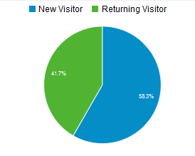
GoGeomatics average web stats for 2013
You will be joining current participants like:


Contact [email protected] to join or for additional details.


Be the first to comment