• facebook
  • Twitter
  • Linkedin
  • Youtube
  • Linkedin Group
  • Post a Job
  • Post an Ad
  • Post an Event
  • Post a Directory Listing
  • Post a Press Release
  • Media Kit
  • My Account
  • Shopping Cart
  • Login
GoGeomatics
  • MAGAZINE
    • BIM & GIS
    • Community
    • Conference news
    • Earth Observation
    • Education & Careers
    • GEOAI
    • Announcements
    • Reality Capture & Lidar
    • Science
    • Technology
    • Between the Poles
  • Directories
    • ASSOCIATION
    • INDUSTRY
    • EDUCATION
    • Open Data
  • EVENTS
    • GeoIgnite Events
    • Events Calendar
    • GoGeomatics Meetups
  • Services
    • Advertising
    • Marketing
    • Post a Job
    • Post an Ad
    • Post an Event
    • Post a Press Release
    • Post a Directory Listing
    • Media Kit
    • Web Design
  • Find a Job
  • Volunteer
    • Start a GoGeomatics Group
    • Editors & Writers Group
  • About Us
    • About Us
    • Contact Us
    • Frequently Asked Questions
  • Videos
HomeBetween the Poles – The Geoff Zeiss ArchivesEngineering

Engineering

3D data

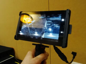
Handheld scanners set to revolutionize construction

16 April 2014 Geoff Zeiss

At the SPAR International Conference today Kirk Knorr from Burns & McDonnell and Gregory Lawes of point3D gave a presentation about their experience using a handheld scanner from DotProduct LLC.  This is a professional device […]

3D data

3D is transforming the construction industry and helping to build a new world

1 April 2014 Geoff Zeiss

Increasing urbanisation, pressure on existing infrastructure, push for productivity in construction sector and environmental concerns are driving the convergence of geospatial, 3D and information modeling technologies. Over the next two decades, construction of buildings and […]

3D data

Report predicts that low cost LiDAR will be disruptive in next 5 years

20 February 2014 Geoff Zeiss

Markets and Markets has released a report that analyzes the LiDAR (Light Detection and Ranging) market by product types (airborne, mobile, terrestrial and short range) and applications (government, civil engineering, military/defence/aerospace, corridor mapping, topographic surveying, […]

3D data

“Design in context” breaks down the barriers between geospatial and design

5 February 2014 Geoff Zeiss

At the Middle East Geospatial Forum in Dubai, Richard Humphrey, Senior Director at Autodesk, gave a vision of the future entitled The Future of Geo-enabled Design that captures at a high level where the convergence […]

Between the Poles – The Geoff Zeiss Archives

Industry outlook in the process, power and marine (energy) sector

5 June 2013 Geoff Zeiss

At the HxGN conference in Las Vegas this morning, a very intriguing perspective on the process, power and marine (PP&M) industry (weighted toeward energy) outlook was presented by Gerhard Sallinger, President of Intergraph Process Power […]

Between the Poles – The Geoff Zeiss Archives

Convergence of geospatial and building information modeling (BIM) accelerates

28 May 2013 Geoff Zeiss

About a decade ago Dave Sonnen, Global Analyst for Spatial Information at IDC, projected that the locationaware market for geospatial services would exceed the traditional GIS market in 2005/2006. The release of Google Earth in […]

Between the Poles – The Geoff Zeiss Archives

Reusing integrated geospatial and design data across the construction lifecyle

21 May 2013 Geoff Zeiss

One of the most important things that impressed me at the Geospatial World Forum 2013 (GWF 2013) conference in Rotterdam is the degree to which in the Netherlands that building information modeling (BIM) and geospatial […]

Between the Poles – The Geoff Zeiss Archives

Integrating geospatial into construction: the challenge

20 May 2013 Geoff Zeiss

I spent most of last week at the Geospatial World Forum 2013 (GWF 2013) in Rotterdam, which was an amazing event, because of its focus on monetizing geospatial value in vertical industries,  Industries for which […]

Posts pagination

« 1 … 4 5 6 7 »

Events

Notice
There are no upcoming events.

View All Events

Services

  • Post a Job
  • Post an Ad
  • Post an Event
  • Post a Directory Listing
  • Post a Press Release
  • Media Kit
  • My Account
  • Shopping Cart
  • Login

Jobs

Post a Job
  • Asset/GIS Coordinator
    Edson, AB
  • Senior Manager, Data Science – Geospatial
    Mississauga, Ontario
  • AI Manager
    Brampton, Ontario
  • Asset Management Coordinator
    Bracebridge, Ontario
View All Jobs
  • Directories
    • Associations Directory
    • Industry Directory
    • Education Programs
    • Open Data
  • Volunteer
    • Start a GoGeomatics Group
    • Editors & Writers Group
  • About Us
    • GoGeomatics Media Kit
    • Who We Are
    • Contact Us
    • FAQ’s
    • Advertising
    • Marketing
  • Subscribe
GoGeomatics
GoGeomatics is the largest and most popular communications hub promoting the Canadian geospatial community. The business was incorporated in 2011. GoGeomatics hosts over 100 fun, free, location technology networking events each year in cities across Canada.

© 2026 GoGeomatics

  • facebook
  • Twitter
  • Linkedin
  • Youtube
  • Linkedin Group