• facebook
  • Twitter
  • Linkedin
  • Youtube
  • Linkedin Group
  • Post a Job
  • Post an Ad
  • Post an Event
  • Post a Directory Listing
  • Post a Press Release
  • Media Kit
  • My Account
  • Shopping Cart
  • Login
GoGeomatics
  • MAGAZINE
    • BIM & GIS
    • Community
    • Conference news
    • Earth Observation
    • Education & Careers
    • GEOAI
    • Announcements
    • Reality Capture & Lidar
    • Science
    • Technology
    • Between the Poles
  • Directories
    • ASSOCIATION
    • INDUSTRY
    • EDUCATION
    • Open Data
  • EVENTS
    • GeoIgnite Events
    • Events Calendar
    • GoGeomatics Meetups
  • Services
    • Advertising
    • Marketing
    • Post a Job
    • Post an Ad
    • Post an Event
    • Post a Press Release
    • Post a Directory Listing
    • Media Kit
    • Web Design
  • Find a Job
  • Volunteer
    • Start a GoGeomatics Group
    • Editors & Writers Group
  • About Us
    • About Us
    • Contact Us
    • Frequently Asked Questions
  • Videos
HomeGEOAI

GEOAI

Earth Observation

DND Seeks Public Input on Southern Ontario Sites for Arctic Over‑the‑Horizon Radar Program

20 July 2025 GoGeomatics Canada | A-OTHR

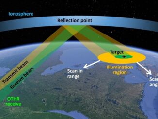
The Department of National Defence (DND) is seeking public feedback on the Arctic Over-the-Horizon Radar (A-OTHR) program in southern, Ontario, part of a key NORAD modernization initiative. As part of an announcement published last week, the DND stated that it aims […]

Mapex
GEOAI

Azure Clouds Rebrands as Mapex AI with Global Vision

20 July 2025 GoGeomatics Canada | AI-Powered Mapping

Mapex AI, a next-generation geospatial intelligence company, has officially launched global operations with the opening of its new client servicing office in Toronto, Canada. Formerly known as Azure Cloud Services and founded in India, Mapex […]

Hexagon Erdas
BIM & GIS

When Every Minute Counts: How Hexagon Tools Speed Up Geospatial Decisions

17 July 2025 Bruce Chaplin | agriculture

Farmers need to know which fields need water today, not next week. When satellite images sit unprocessed, crops suffer, and decisions get delayed. City planners stare at screens filled with infrastructure data, knowing somewhere in […]

GEOAI

Canada Eyes Sovereign Underwater Surveillance with AI-Driven Acoustic Tech

12 July 2025 GoGeomatics Canada | Arctic Sovereignty

The Department of National Defense is seeking efficient passive Detection, Classification, Localization, and Tracking (DCLT) algorithms to acoustically track vessels of interest using Defense Research and Development Canada’s acoustic sensors subject to different environmental conditions. […]

June 30 Digest
BIM & GIS

International Geospatial Digest June 30, 2025

30 June 2025 Volunteer Editors and Group Writers | AI

Saving Dying Reefs with Earth Engine and AI Bureaucratic Issues Facing a Joint European Space Conglomerate ESA Biomass Satellite returning long-awaited images NASA Sensor Identifying Polluted Run-off on California Coast Redrawing the Global Tea Map […]

Don Murray
BIM & GIS

Inside Safe Software’s Global Push: CEO Don Murray on Expansion, AI, and Staying Canadian

27 June 2025 Anusuya Datta | AI and Data

Safe Software, the Canadian company behind the FME platform, has expanded into the United Kingdom and Ireland — a strategic move aimed at strengthening its global footprint and accelerating growth across the Europe, Middle East, […]

co-hosting
BIM & GIS

Growing Together: How Co-Hosted Events Are Uniting Canada’s Geospatial Communities

20 June 2025 GoGeomatics Canada | BIM

At GoGeomatics, we believe Canada’s geospatial future belongs to many voices — not just one. From GIS and BIM to Earth Observation, cartography, open source, and user groups, our sector thrives when communities have space […]

Earth Observation

From Curiosity to Climate Action: Nicholas Kellett on Deploying AI for a Changing Planet

9 June 2025 Benedicta Antwi Boasiako | #RemoteSensing

Deploy Solutions is a Canadian geospatial company focused on climate adaptation and resilience. Founded in 2016, the company pivoted into the space sector in 2019, choosing to concentrate on the downstream side of the industry […]

Posts pagination

« 1 … 10 11 12 … 17 »

Events

Notice
There are no upcoming events.

View All Events

Services

  • Post a Job
  • Post an Ad
  • Post an Event
  • Post a Directory Listing
  • Post a Press Release
  • Media Kit
  • My Account
  • Shopping Cart
  • Login

Jobs

Post a Job
  • Asset/GIS Coordinator
    Edson, AB
  • Senior Manager, Data Science – Geospatial
    Mississauga, Ontario
  • AI Manager
    Brampton, Ontario
  • Asset Management Coordinator
    Bracebridge, Ontario
View All Jobs
  • Directories
    • Associations Directory
    • Industry Directory
    • Education Programs
    • Open Data
  • Volunteer
    • Start a GoGeomatics Group
    • Editors & Writers Group
  • About Us
    • GoGeomatics Media Kit
    • Who We Are
    • Contact Us
    • FAQ’s
    • Advertising
    • Marketing
  • Subscribe
GoGeomatics
GoGeomatics is the largest and most popular communications hub promoting the Canadian geospatial community. The business was incorporated in 2011. GoGeomatics hosts over 100 fun, free, location technology networking events each year in cities across Canada.

© 2026 GoGeomatics

  • facebook
  • Twitter
  • Linkedin
  • Youtube
  • Linkedin Group