• facebook
  • Twitter
  • Linkedin
  • Youtube
  • Linkedin Group
  • Post a Job
  • Post an Ad
  • Post an Event
  • Post a Directory Listing
  • Post a Press Release
  • Media Kit
  • My Account
  • Shopping Cart
  • Login
GoGeomatics
  • MAGAZINE
    • BIM & GIS
    • Community
    • Conference news
    • Earth Observation
    • Education & Careers
    • GEOAI
    • Announcements
    • Reality Capture & Lidar
    • Science
    • Technology
    • Between the Poles
  • Directories
    • ASSOCIATION
    • INDUSTRY
    • EDUCATION
    • Open Data
  • EVENTS
    • GeoIgnite Events
    • Events Calendar
    • GoGeomatics Meetups
  • Services
    • Advertising
    • Marketing
    • Post a Job
    • Post an Ad
    • Post an Event
    • Post a Press Release
    • Post a Directory Listing
    • Media Kit
    • Web Design
  • Find a Job
  • Volunteer
    • Start a GoGeomatics Group
    • Editors & Writers Group
  • About Us
    • About Us
    • Contact Us
    • Frequently Asked Questions
  • Videos
HomeGEOAI

GEOAI

Education & Careers

Using Geospatial Intelligence to Unmask Montreal’s Underreported Methane Super-Emitters

4 February 2026 Alefiya Dungrawala | CH4 hotspots

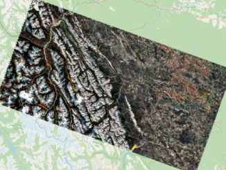
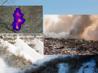
When McGill researchers mapped Montreal’s methane hotspots, they expected to find old landfills. Instead, they found a massive “super-emitter” in the city’s largest snow dump. Densely populated urban centers are more than just hubs of […]

Earth Observation

International Geospatial Digest – February 2, 2026

2 February 2026 Volunteer Editors and Group Writers | agriculture

New NOAA Project Looks to Map Critical Mineral Deposits on Seafloor Off American Samoa UK Space Agency Funds Two New Agricultural Initiatives NOAA Launches New Wildfire Monitoring Data Portal Planetary Intelligence Harnesses the Power of […]

Community

How GIS and Remote Sensing Validate Indigenous-Led Stewardship

14 January 2026 Alefiya Dungrawala | #GeospatialCommunity

For decades, the conversation around conservation in Canada has been dominated by a “fortress” model—federal and provincial parks managed by central agencies. However, a landmark study released on January 6, 2026, by researchers at Concordia […]

Community

Shape the North: Help Evolve GEO.ca, Canada’s Hub for Geospatial Data

12 January 2026 GoGeomatics Canada | #GeospatialData

In an era where data drives decisions—from climate resilience to urban planning—having a reliable “digital twin” of our country is essential. Whether you are a professional GIS analyst mapping infrastructure, a researcher studying environmental shifts, […]

Earth Observation

Canadian Geospatial Digest – January 12, 2026

12 January 2026 Volunteer Editors and Group Writers | 3D Digital twin

PhotoSat Launches Regional Hyperspectral Targeting Tool for Mineral Exploration NordSpace’s Atlantic Spaceport Clears Environmental Review, Moves Toward Canada’s First Orbital Launch Site 3D Mapping Pilot Shows How Indoor GIS Could Improve Safety in Edmonton’s LRT […]

Geospatial 2025 FI
Earth Observation

Geospatial in 2025: A Year of Structural Realignment

2 January 2026 Anusuya Datta | Artificial Intelligence

For most of the past decade, the geospatial industry has moved forward in predictable ways. Better sensors, more satellites, faster processing, and incremental improvements stacked on top of existing workflows. 2025 doesn’t fit that pattern. […]

Earth Observation

What Is Planaura? A Guide to Canada’s Geospatial Foundation Models

22 December 2025 Alefiya Dungrawala | Artificial intelligence (AI)

A new class of artificial intelligence is changing how we understand the planet. Known as foundation models, these systems are trained on massive, planetary-scale datasets drawn from satellites, sensors, and geospatial platforms, allowing scientists and […]

Community

International Geospatial Digest – Dec 15, 2025

15 December 2025 Volunteer Editors and Group Writers | 3D Mapping

19 Countries in the Americas Trained in Geospatial AI for Faster Emergency Analysis Russia Restricts Nighttime Mobile Networks to Disrupt Drone Operations Guided by Geolocation Signals Geopost Transforms Delivery Fleet into a High-Frequency Mapping Asset […]

Posts pagination

« 1 2 3 … 17 »

Events

Notice
There are no upcoming events.

View All Events

Services

  • Post a Job
  • Post an Ad
  • Post an Event
  • Post a Directory Listing
  • Post a Press Release
  • Media Kit
  • My Account
  • Shopping Cart
  • Login

Jobs

Post a Job
  • Asset/GIS Coordinator
    Edson, AB
  • Senior Manager, Data Science – Geospatial
    Mississauga, Ontario
  • AI Manager
    Brampton, Ontario
  • Asset Management Coordinator
    Bracebridge, Ontario
View All Jobs
  • Directories
    • Associations Directory
    • Industry Directory
    • Education Programs
    • Open Data
  • Volunteer
    • Start a GoGeomatics Group
    • Editors & Writers Group
  • About Us
    • GoGeomatics Media Kit
    • Who We Are
    • Contact Us
    • FAQ’s
    • Advertising
    • Marketing
  • Subscribe
GoGeomatics
GoGeomatics is the largest and most popular communications hub promoting the Canadian geospatial community. The business was incorporated in 2011. GoGeomatics hosts over 100 fun, free, location technology networking events each year in cities across Canada.

© 2026 GoGeomatics

  • facebook
  • Twitter
  • Linkedin
  • Youtube
  • Linkedin Group