
Technology

Quantum Spatial Canada Supports Disaster Preparedness on Vancouver Island Through Lidar Survey Covering 9000 Square Kilometers
Located off the Pacific Coast of British Columbia, Vancouver Island is home to just under 900,000 people, as well as…
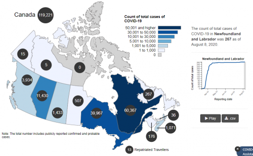
Your Canadian Geospatial Briefing for August 10th: Initiatives help youth address climate change; Mapping mask-mandatory businesses; Vancouver Island First Nations roll out tsunami mapping; COVID-19 mapping resource
Groundbreaking initiatives help Canadian youth address climate change Two Canadian charities are taking a stand and inspiring action against climate…

GEOAnalytics.ca – A demonstration cloud-native open platform for Big Data geoscience
Current data-driven and computing intensive research on climate-change, ecosystem modeling, and environmental and natural resources monitoring is based on the…

Your International Geospatial Briefing for July 20th: Penn State with new online master’s degree; Virtual wall for concrete wall; New book in archaeology and GIS; Mapping tar when recycling asphalt
New online master’s degree in spatial data science Pennsylvania State University has launched a new online master’s degree in spatial…

Géoclip – A geostatistical observatory software product
The Géoclip observatories are web applications for statistical mapping to promote the analysis of territorial data sets. A Géoclip observatory…

Your Canadian Geospatial Briefing for July 14th: Data Visualization to Forecast Avalanches; Interactive Map the Stories of Sixties Scoop survivors; Drone-Based Thermal Infrared Data with ArcGIS Drone2Map; MDA to build Canadarm3;
Using Data Visualization to Quickly Forecast Avalanches and Enhance Public Safety Avalanche prediction requires location and elevation specific weather data…

Your International Geospatial Briefing for July 6th: Facebook buys mapping start-up; NASA, ESA and JXA join to visualize the pandemic; UK with new geospatial strategy; Mapping supply chains in COVID-19
Facebook buys start-up in latest push to take on Apple and Google at street-level mapping To take on Apple and…

Discover Business Geografic’s GEO Software platform
GEO Software is Business Geografic’s innovative and powerful GIS and Business Intelligence platform. GEO technologies, protected by an international patent,…
Post-Wildfire Landscape Metrics & Transition Characteristics in Cariboo Regional District, 2017
The summer of 2017 marked one of the worst fire seasons in British Columbia’s history. By October, wildfires had covered…

Low-cost, less-time, lesser-logistics and high-accuracy mapping with drone-imagery
Highlights There is a tendency to use aerial photographs and digital images as the cartographic product!These pictures are the primary…

Your Canadian Geospatial Briefing for June 29th: New tech against wildfires; Bathymetric Lidar mapping; COVID-19 effect Heat maps; Eastern Canada DOT Power Platform; Tim Kopra as Vice President, Robotics and Space Operations of MDA
Scientists armed with new tech and cool gadgets face off against wildfires More extreme weather each spring makes wildfires a…

Your International Geospatial Briefing for June 22nd: Google Maps Platform; Global Partnership on Artificial Intelligence; Geospatial Data Strengthens Electrical Grids; Entire Roman City Mapped Using GPR
Google Maps Platform gaming solution now available to everyone Google first launched a gaming solution to bring real-world games to…
