
Technology

Your International Geospatial Briefing for December 2nd: Can Smart Cities Help You Without Compromising Privacy?; Surveying with Advanced Laser Scanning; Weather Agencies Object to 5G; Campus Work Begins for National Geospatial Intelligence Agency
Can Smart Cities Help You Without Compromising Privacy? Smart cities are built on data. Whether it is street sensors, heated…

Your Canadian Geospatial Briefing for November 25th: Mapping Toronto’s Most Bizarre Intersections; Canada’s 5G Network: USA issues warning; GeoVangelist Wins the 2019 Alex Trebek Medal for Geographic Literacy; Mapping Canada’s Hidden Treasure
Mapping Toronto’s Most Bizarre Intersections For most people from Toronto, when they think of what their city is known for,…
Your International Geospatial Briefing for November 18th: Satellite InSAR Data used to detect massive size of North Korean Nuclear Testing; How GIS Makes IoT Data Come Alive; LiDAR: Promise and Challenge in Autonomous Vehicles; Bill Gates uses mapping tech to curb polio
Satellite InSAR Data used to detect massive size of North Korean Nuclear Testing Following the withdrawal of North Korea from…
Your Canadian Geospatial Briefing for November 11th: A Concerning Data Strategy; Sidewalk Labs in Toronto; Vancouver: Top North American City for tech growth; World-First Satellite Connection to the Arctic with 100Mbps
A Concerning Ontario Data Strategy Teresa Scassa, a professor from the University of Ottawa, has written an interesting piece on…
Your International Geospatial Briefing for November 4th: Is geospatial data the key to leaving no one behind?; OGC updates IndoorGML standard; Observing California’s Wildfires from the Space Station; Major Wood Chip Exporter Now Prefers Drones to Calculate Volumes
Is geospatial data the key to leaving no one behind? Some of our planet’s leaders may still be deliberating the…
Your Canadian Geospatial Briefing for October 28th: Top 15 Largest Engineering Firms in Canada; Scanning the Earth with Lidar; A London Bar Uses Facial Recognition; Drone Delivery Canada and DSV Canada announcement; Canada’s Maritime Launch Services for C4M Upper Rocket Vehicle
Top 15 Largest Engineering Firms in Canada Canada has over 295,000 registered engineers in the country with an expected continuation…
Your International Geospatial Briefing for October 21st: How We Can Use Geospatial Tech for Good; AI: Cheat Sheet; In Chinese children’s film, anger grows over controversial map; What is openBIM and why is it important?; Making IoT More Intelligent with AI
How We Can Use Geospatial Tech for Good The winners of the most recent EthicalGEO Fellowship have been focusing on how geospatial…
Your Canadian Geospatial Briefing for October 15th: Indigenous Mapping Conference Offers New Skills; Launch of Institute for Earth and Space Exploration; Teranet & Nearmap Announce Partnership; N.B Municipalities Using Tech To Make Their Cities Smarter
Indigenous Mapping Conference Offers New Skills Last week was the 6thannual Indigenous Mapping Workshop. This year’s event was in Inuvik,…
Your International Geospatial Briefing for October 8th: Geospatial tech makes human life easier; Core Instrument to Transforming a Country? Geospatial Data.; Historians Map Migrations with Geospatial Tech; MAXAR Develops for the U.S. Air Force
Geospatial tech makes human life easier During the national conference at the Punjab Remote Sensing Centre on Big Geospatial Data…
Your Canadian Geospatial Briefing for September 30th: Trans-Canada Hwy built over sinkhole; AT&T expands IoT; New 5G plan if Canada band Huawei; Contemplating the future of higher education
Trans-Canada Hwy built over sinkhole CBC news has collected images from the National Air Photo Library dating as far back…
Your International Geospatial Briefing for September 23rd: Geomatics institute in Zimbabwe engages youth in the field; Typography as a platform for smart cities and design; Research Project aims to build geospatial AI for landform detection
Geomatics institute in Zimbabwe engages youth in the field The president of the Zimbabwe Institute of Geomatics (ZIG) has recently…
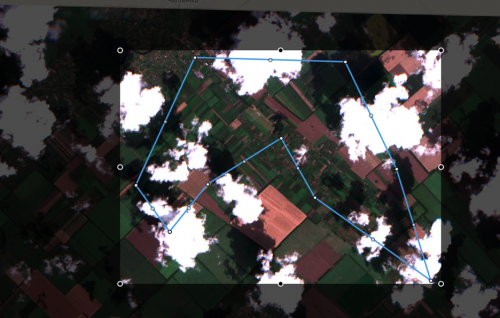
No more blind zones with the Mosaic feature
Undoubtedly the best case scenario while working with satellite imagery is to find the most suitable images for your use-case…
