

Montreal 2017 EO Summit: Is Earth Observation becoming a global partnership for change?
My journey to the 2017 Earth Observation (EO) Summit in Montreal began when I boarded the train and left Union Station in Toronto. During the long train ride I had the chance to think about my aspirations as a geomatics professional. In the future I would like to use my remote sensing and geomatics skills to bring together communities and tackle common problems. I am a graduate from the University of Toronto and the Fleming GIS Applications Specialist program.

Co-chairs: Martin Berberon and Laurent Giugni in the main amphitheater
The EO Summit was held from June 20 to 22 at UQAM and brought together a number of exceptional remote sensing organizations and events in one place. The summit was bilingual featuring over 500 scientists, professionals, governmental and industrial leaders from across Canada and 25 nations. There was close to 400 oral presentations, 150 posters and 700 participants. Globally this was one of the largest EO events happening in 2017.
This summits collaborators included:
- 38th Canadian Symposium on Remote Sensing (CSRS)
- 17th Congress of the Association Québécoise de Télédétection (AQT)
- 11th Advanced SAR (ASAR) Workshop
- 51st Workshop of the Association de Géomatique Municipale du Québec (AGMQ)
Each organization has its own particular focus, but the overarching theme was to bring the sector together to discuss technologies, applications, and the many societal benefits EO brings.
The Canadian Space Agency did a live broadcast from the Summit. Check it out here:
The Keynotes, Talks and Workshops:
The event sprawled through the UQAM Coeur du Science Center class rooms and main meeting spaces. The main amphitheater played host to the keynote speakers giving their talks. The rest of the event was divided into topic sections throughout the four floors of the building. The agenda handed out to participants included floor-plans so we could find our way around. Excellent signage and volunteers, keen to help lost souls find their desired presentations. At each talk I found participants from a variety of sectors attended. I met and listened to people from all levels of government, private companies, and academics to individual applications specialists.
There were many great speakers and unfortunately I was not able to cover them all. What follows are some highlights of the one’s I was able to attend the first two days of the conference.
Topic: Commercialization of EO technology
Speaker: Chris Dodd
Organization: Airbus
Keynote Chris Dodd who is the Director of Business Development spoke on Airbus’s sophisticated geo-information services and the importance the company places on investing to commercialize EO technology. Airbus is a world leader in space systems with a constellation of EO satellites collecting radar and optical data. It’s radar satellites include TerraSAR-X (which recently celebrated 10-years of flawless in-orbit operation) and its satellite twin TanDEM-X. These X-band satellites were built by Airbus through a PPP co-investment business model with the German space agency. Airbus is now investing in the development of its next generation of Earth observation sensors such as the VHR2020 optical and the WorldSAR constellations. In addition, Airbus is investing to develop new data services and value added products. These include SmartData Analytics, Premium Data, and 25 cm high-resolution SAR imagery which will be a comparable alternative to optical imagery. The new imagery products developed by Airbus include “OneAtlas”, a new web based data library that accessible to users or developers; “PickMeApp” a new product geared to the consumer market which allows images to be purchased on a one-of basis; and the “SmartGeo Platform” which supports SAR data processing and access in the Cloud. Airbus understands that the Earth observation industry is evolving and needs to adjust to these changes. The continued investment in the commercialization of space segment technologies, and data products and services will continue to central to its business strategy.
Topic: Using Big Data to Reach out a Helping Hand Across the Globe
Speaker: Steven Ramage
Organization: GEO
Keynote speaker Steven Remage GEO Secretariat talked about Group on Earth Observations (GEO) and their continued efforts with GEOSS (Global Earth Observation System of Systems). GEO is a partnership of more than 100 national governments and more than 100 Participating Organizations that envision a future where humankind takes accountability through coordinated, comprehensive and sustained EO. GEOSS is a central part of GEO’s Mission which coordinates independent EO, information and processing systems that interact and provide access to diverse information for a broad range of users in both the public and private sectors. An example of GEOSS contributions was when they provided disaster resilience using Sendai Framework, a major agreement of the post-2015 development agenda, to organize a sustainable development work program for the Paris Accord. GEOSS’s goal is to work in partnerships to mobilize fleets of aid workers for when disasters strikes in areas of clean water issues, protection against flooding, or transportation routes.
Panel Discussion
Topic: Commercialization of EO Workshop
Moderator: Markus Jochum from Airbus Speakers: Desmond Power from C-CORE, Jacque Giroux from ABB and Marco Van Der Kooij of MDA
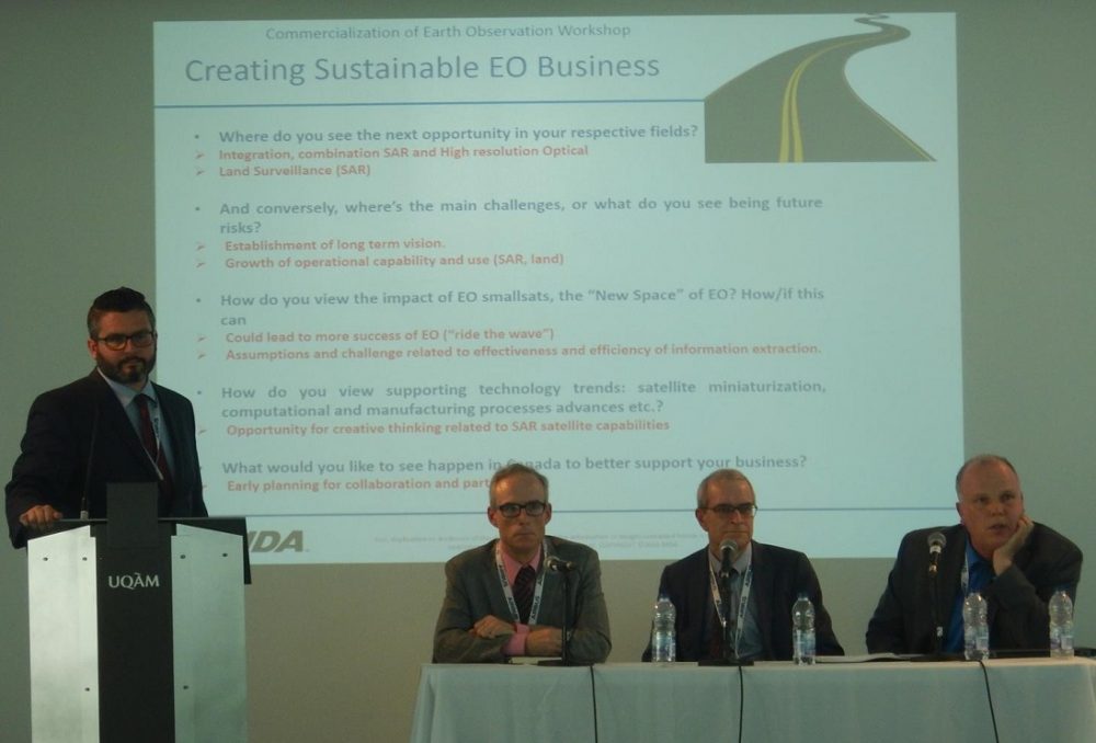
Panel Discussion: Desmond Power, Jacque Giroux and Marco VanDer Kooij
Desmond Power, Vice President, Remote Sensing (C-CORE) talked about C-CORE’s efforts to commercialize an earth observation-based service that was designed for the oil and gas industry. The talk was focused on how difficult and time consuming it generally takes to commercialize satellite services, because they can be disruptive to existing practices. The service is an iceberg surveillance service based on satellite synthetic aperture radar. The technical challenge is early detection of icebergs on the Grand Banks, near oil producing platforms, so that the icebergs could be managed (towing, water cannon). Desmond presented a timeline of the service evolution from early research, to prototyping, to pilot testing and finally to adoption by the oil and gas industry as a legitimate service.
ABB’s Jacque Giroux Business Development Manager gave his perspective on the issues facing satellite suppliers of optical hyperspectral payloads to collect atmospheric measurements. ABBs challenge is on how this company is streamlining its regional structure power systems for greater agility and speed to export data simulations for the industrial, space and defense markets.
Marco van der Kooij, the Director of Advanced SAR Solutions at MDA discussed providing cost-effective global delivery of communications, surveillance and intelligence solutions. He summarized MDA’s recent acquisitions such as Space Systems Loral in 2012 and in particular that of Digital Globe earlier this year. The acquisitions demonstrate a U.S. and international focus and have resulted in expanded capabilities and vertical systems integration for its Earth Observation Business. RADARSAT-2 is its current workhorse for SAR business (data and value added (information) products). Recent business trends include a growing success of SAR surveillance solutions (“analytics”) for both maritime and broad area land applications.
Topic: Data, Data everywhere, but how does everyone drink?
Speaker: Graham Stickler
Organization: Skywatch, Mission Blue, Beyond 180

Graham Stickler, Skywatch
Graham Stickler is the CMO at Skywatch, CTO at Mission Blue, and President at Beyond 180. Here Graham presented on Skywatch’s platform that provides an API that administers a single point interface to accesses the widespread marketplace of remote sensing datasets. This platform performs the hosting and processing and delivery of remote sensing data by pixel rather than tiles/scenes providing the user only their Area of Interest. This platform is designed to be user friendly targeting the non-specialist developer, with the aim of bringing amazing change and widespread growth to geospatial analytics and the use of EO data.
Topic: Validating EO derived products during natural disasters using crowdsourcing geographic information
Speaker: Vincent Decker
Organization: Natural Resource Canada

Vincent Decker, Natural Resource Canada
NRCan’s Vincent Decker gave a great talk on how to track areas that are flooding using crowdsourced data. This mobile app pilot project accepted over 400 location and image submissions by the public on flood data across Canada during this last year. The flood photos from the public required a scalable database for incoming submissions. Now the project is moving on to automate a photo validating process by filtering out faces and removing junk observations in real time using machine learning.
Topic: The Canadian wildland fire information system (CWFIS): online
Speaker: John Little
Organization: Natural Resource Canada
John Little from NRCan talked about tracking wildland fire in near real time. They use something called the Canadian Wildland Fire Information System (CWFIS). This interactive web application is publicly available and includes information and data services on current and historical wildland fires. Some additional CWFIS products and service are not available to the public but are used by professionals for fire management, monitoring and reporting on wildfires that occurs across Canada. Many types of data are pulled into the system for monitoring fire conditions and fire occurrence. For example, data from multiple satellite sensors are used to identify hotspot locations and a buffer process provides a fire perimeter estimate in near real time based on these hotspot. Processes are also run to model and predict fire growth/spread over a 24/48 hour period. CWFIS data services enable clients to tap into these live data feeds for various applications that require current wildland fire conditions.
Topic: Northstar: Changing the way we see the world
Speaker: Kjell Stakkestad
Organization: KinetX Aerospace, Inc.
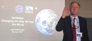
Kjell Stakkestad, KinetX
Kjell Stakkestad serves as Chief Executive Officer and President of KinetX Aerospace, Inc. He spoke about his companies goals KinetX specializes in aerospace systems, solving engineering challenges with technology, software and development for complete systems solutions. KinetX observes objects orbiting in space to avoid collisions and organizes airplane flight navigation patterns all around the world. They are interested in partnerships that solve today’s global issues effected by climate change.
Topic: Terrestrial LiDAR for enhancing forest inventory
Speaker: Richard Fournier
Organization: University of Sherbrooke
Richard Fournier, professor at the Department of Applied Geomatics at the Université de Sherbrooke, spoke on the availability of new algorithms designed to use point clouds from terrestrial or portable LiDAR to improve current forest inventory data. These algorithms are designed to identify individual trees within a stand, estimate stem taper and branchiness, estimate tree merchantable volume or overall above ground biomass. The implementation of these algorithms have the potential to improve the inventory through better estimates on a larger spectrum of structural attributes, which supports better decisions on forest operation and strategic planning at the tree and stand level.
Poster Presentation:

Rachel Kuzmich, Queen’s University
Would any geospatial summit be complete without a student poster competition? Of course not! There were many participants in the poster sessions but here are a couple of my favorites.
Rachel Kuzmich is a masters student at Queen’s University and group leader for GoGeomatics in Kingston. She presented her undergraduate thesis poster on the detection and classification of forest disturbances in the Alberta oil sands region using Landsat time series data.
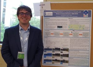
Justin Murfitt, University of Toronto Mississauga
Justin Murfitt received 1st place for the best student poster presentation. He is a masters student from the University of Toronto and been working on developing a method for creating a complete record of ice phenology in Central Ontario. His focus has been in the Haliburton Region which is a popular destination for snowmobiling, ice fishing and dog sledding. The poster describes the uses of RADARSAT-2 images acquired between 2008-2016.
Networking Opportunities:
The Breaks:

Coeur de Science Centre’s fourth floor main room, Ployvalente
The Coeur du Science Center’s fourth floor main room called the Polyvalente held the exhibitor booths and served as the place for everyone to grab coffee and our lunch breaks. The lunches consisted of catered in box lunches with a variety of great tasting choices. There were table tops for standing and tables to sit which made the area good for socializing between presentations.
A Special EO Banquet:

Banquet location: Panoramic Hall of Montreal Science Center
A bus picked us up from the Coeur du Science Center building and drove us to the Panoramic Hall of Montreal Science Center for the banquet dinner. The building was inspired by the public markets of the old port and is in the old port itself.
Our evening began with cocktails in the lobby accompanied by live pop culture music covers. For dinner we moved inside a picturesque glass room looking out over the old port. The music and food was amazing.

Inside at the banquet
During the banquet I could see and hear lively conversations taking place. Our table discussed the upcoming talk relating to the ‘History of Canadian Remote Sensing’. I spoke to a government of Canada Remote Sensing Agency representative about his career and how he got into with his current government position.
A Successful Event:
During the course of the summit the feedback I received from participants was all positive. Everyone was impressed with quality and organization of the event.
In particular, I loved the presentations on how big data is collected, sorted using machine learning and then results fed into web applications. All the recent advances in remote sensing have enabled the sector to collect massive data sets. But what do we do with it? Big data is the future. It will be those organizations and individuals who are able to organize and interpret this huge volume of data that will lead us in the future.
I really enjoyed two presentations. The first was Graham Stickler talking about how Skywatch takes a variety of satellite datasets for your desired location and organizes the data into one area such that it is readily available at your finger tips. The second one was NRCan’s Vincent Decker speaking about using crowdsourcing data to view areas that are flooding on a web application.
Many of the discussions at the summit centered around forging partnerships to standardize imagery data and make it accessible to the wider marketplace or consumers in general. My experiences working with GIS and Remote Sensing has furthered my interest in Data Sciences.
The next Canadian Symposium on Remote Sensing will be from June 19 – 21, 2018 and held in Saskatoon, Saskatchewan.
A big thank you goes out to the sponsors that has made this a spectacular event, such as Airbus, MDA, Effigis Geo Solutions, Kepler, KIM Geomatics, the Québec Government, UQAM and of course GoGeomatics Canada as a media sponsor.
GoGeomatics Canada thanks all people who made my attendance possible: Martin Bergeron, Laurent Giugni, Patrick Plourde, Monique Bernier, Desmond Power, and François Cavayas.
Follow this link to a gallery of pictures from the event that I have captioned for your enjoyment.


