

Non-GPS PNT – NextNav
Beacons of Hope for Positioning, Navigation and Timing Alternatives
Whenever we hear people talk enthusiastically about 3D digital twins, real-time mapping, “metaverses”, or flying autonomous taxi drones, we have to keep in mind that such things rely heavily on GPS* for the critical “where” and “when”. And GPS/GNSS does not always work well everywhere and could potentially stop working in unpredictable situations.
How do you solve for accurate location, and elevation when in GNSS denied or degraded situations? Some approaches use ground-based beacons. We examine one such solution from NextNav, a firm that did quite well in recent US Department of Transportation tests of PNT alternatives. And we tested their solution for the tricky challenge of determining floor-level elevation.
As a follow-up to our April 18, 2021 feature “Progress in Addressing GPS/GNSS Vulnerabilities” where we examined the vulnerabilities, but also the positive steps being made to proactively solve the issues, we offer this, the second installment of a series where we explore Alt PNT technologies and the present work of developers and solution providers.

Drivers and Drivers
The pursuit of Alt PNT is not driven purely out of the fear that somehow the GPS constellation will suddenly be rendered unusable in the long term (though the specter of jamming and spoofing is a real concern). The other drivers are for reliable positioning, navigation, and timing where GNSS does not work well, or at all. Like indoors, in dense urban canyons where there might be limited sky view or signal multi-path hazards, or where there might be interference. NextNav is a firm that provides solutions that can operate completely independently of GNSS, for these scenarios and more. The founder and CEO of NextNav, Ganesh Pattabiraman, was previously with Qualcomm, the source of many of the GNSS enabled chips that are in consumer devices like cell phones. He observed the performance of GNSS in urban settings and felt there should be more precise and reliable alternatives.
“The prime driver was 911. And the difficulty of giving accurate positioning in a metropolitan and deep urban environment,” says Ashutosh (Ashu) Pande, VP and General Manager of TerraPoiNT at NextNav. “For the longest time, aside from the complimenting of GNSS with Wi Fi or Bluetooth, GNSS accuracy by itself is somewhere in the order of 40-50 meters deep in such environments,” says Pande. “And if you start looking at the hemisphere that gets created with a radius of 50 meters, that’s quite a lot of buildings.” So even if the consumer feels confident that they have GNSS and have made the 911 call, finding them might take more time than they envision.
Now think of other positioning and navigation applications that are heavily reliant on GNSS; delivery services, consumer navigation, location-based services, etc. OK, maybe +/- 50m is more inconvenient than prohibitive, but when you consider autonomous vehicles, and proposed drone air taxi services, the public safety considerations are critical. Robot drivers are definitely another driver for Alt PNT.
Beacons
With this mission in mind, NextNav was formed in 2008 and began developing what was originally called the Metropolitan Beacon System (MBS). This consists of networks of towers that transmit synchronized signals that end user devices can use to determine location. It uses signal ranging techniques, much like GNSS. And depending on the density of the tower network, and local conditions, it can deliver 5m-10nm in urban environments, sometimes better. You do not have to worry about sky view, it can extend indoors, and even down one or two floors.
One of the keys is timing. Like any signal ranging solution, where the speed of a signal from the time it left the transmitter to the receiver gives you a distance, and multiple signals provide a position through trilateration, precise time is crucial. This is why NextNav has put small atomic clocks on their towers. GNSS satellites have atomic clocks onboard, and these are updated/synchronized from the ground contour segment. In a similar manner, NextNav has “leader” towers/clocks (that get time via a Cesium clock, LEO satellite, fiber-based timing, or other precise time sources) and its two-way time transfer technology keeps the “follower” towers updated/synchronized.
Like any radio ranging solution, the signals are susceptible to multi-path (bouncing off objects) and potential jamming and spoofing. But being transmitted in the 900MHz range, at much higher power than GNSS signals, these hazards are less pronounced. Plus, those frequencies are able to penetrate indoors and “into the basement”; whereas GNSS signals cannot.
But What Floor?
Certainly, the more precise location capabilities provided by such solutions enhance 911 response scenarios. But there can still be a weakness in the vertical component: “what floor in the high rise commercial or residential building is the caller on?” NextNav then developed a solution specifically to enhance the vertical results.
For the horizontal positioning and navigation—and precise timing—we have TerraPoiNT,” says Pande. “This is what was formerly called MBS. We can be quite confident on the X and Y, to lane level accuracy. But even with uncorrected GNSS out in the open, you might not be able to get the 3m vertical, 90% of the time being sought to determine what floor of building someone is in. This is because of the geometries involved. To do that we have integrated data from pressure sensors in our solution.”

With GNSS, you first compute horizontal position and thus your vertical precision is typically 1.5x-2x the horizontal. NextNav developed what they call Pinnacle, that flips this the other way around, where the vertical is computed first and hence is typically better than the horizontal. This is achieved through differentials in air pressure. Many surveyors will be familiar with the technique of using two or more barometers, calibrating them together then observing the differential in pressure as one is moved to a different elevation. “Almost all the mid to high end smartphones have a pressure sensor now. But they have inherent challenges; they’re not very precise, they have drift, they have initial bias, all these problems that come with mass market products,” says Pande. “We’ve developed algorithms that correct for the bias, and that correct for the drift. We’ve built a reference pressure network that corrects for the micro changes in weather conditions to deliver 3m vertical positioning > 90% of time.”
“We need this terrestrial network of towers for the 3D positioning, to enable TerraPoiNT, and we share this network to support Pinnacle,” says Pande. NextNav has built a nationwide footprint of weather stations. But these are not like traditional weather stations where only 1 or 2 might serve and region the size of the Bay Area, these are collecting micro-climate data, and instead there would be about a dozen in the same area. They are collecting data round the clock and send this to the NextNav servers. On the phone side the pressure from the onboard sensor has been normalized, removing the biases and the drift. And you have the X and Y from the phone, so then simple math takes place. The weather station closest to the location is saying that the pressure above terrain at its height is “xxx”. The GNSS in the phone provides a height above ellipsoid, from which a hybrid geoid model can be applied to derive an elevation relative to sea level. The pressure differential is applied to give you the elevation of your phone. This may be an oversimplification of all that this automated process entails, but you get the idea.
Trying Pinnacle
One advantage of the Pinnacle solution is that it does not require any special hardware beyond what your phone has: just a connection to the internet and the service. When I saw on the Pinnacle coverage map that my city was included, I downloaded the developer app for my phone to test it out. You have to do a simple calibration step first: hold it at waist height (where you would typically be carrying your phone) above some open sky spot at ground level. Instead, I set it right on a survey benchmark for the test. Then I tried it seven floors up on our roof where I have a set of test benchmarks I established with a survey-grade GNSS instrument.
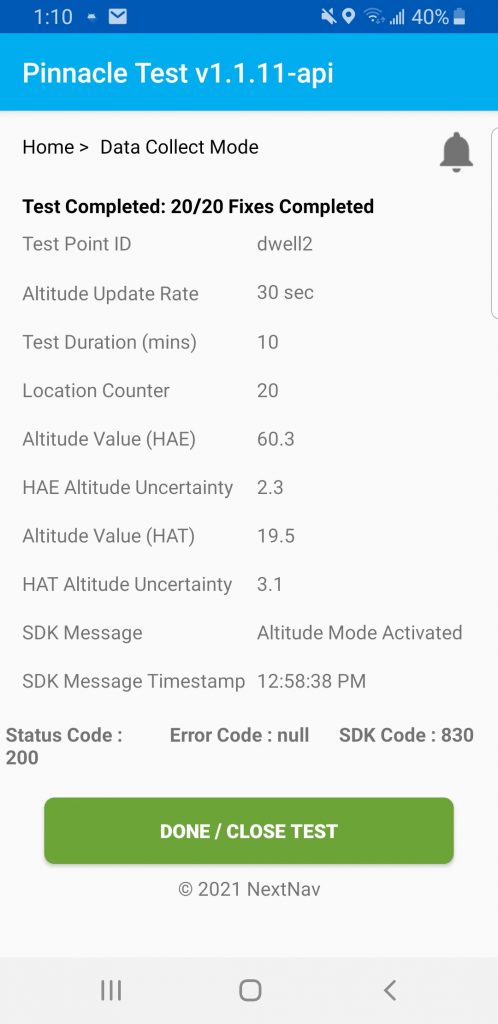
Over a week, in different weather conditions (with slightly varied barometric pressures) I took more readings. They typically fell within 2-3 feet of my reference elevations; far better than the 9 feet needed and any expectations for an uncorrected cell phone elevation. But for a 911 call scenario, the true test would need to be indoors. Measuring down the stairwell to my floor, I taped some test marks to the floor in different rooms and took readings while introducing conditions that I would assume might affect the pressure; fan on/off, windows open/closed, and on different days. I hit almost all readings between 3-7 feet. Maybe I was just lucky, but this was impressive, and I’ll do more readings when the weather forecast shows high- or low-pressure cells in the area.
Pande says “The FCC has done extensive testing along with CTIA. And those results are available on the FCC website. They tested in multiple cities, different building types, different heights. And 94% of the time, we were better than three meters, which is floor level accuracy.” Presently, NextNav’s Pinnacle service for vertical positioning is available in 4,400 cities (representing the top 105 Cellular Market Areas) across the United States.
When Can Everyone Use NextNav?
While Pinnacle, for the improved vertical, is something that could be implemented on most phones right now, when will the enhanced 3D positioning from NextNav’s TerraPoiNT be readily available? This is the focus for Pande, and he has been through this kind of implementation before.
“About 20 years ago I was working for SiRF, a company that pioneered commercial GNSS applications for consumer use,” says Pande. “We were looking at miniaturizing GNSS and making it available for consumers, and we worked with a Finnish company called Benefon that launched the first GPS enabled cell phone in 2000. And the rest is history.”
NextNav has devices, with 900MHz range receivers, that can utilize the TerraPoiNT beacons, already in circulation for various applications. Pande says that they also have their solution integrated into two mass market chipsets. One is from Broadcom, and the other one is from a company called GCT Semiconductor out of Korea. Plus, they are just about to launch a small Bluetooth peripheral for cell phones that will be about the size of a standard phone charger “wall wart”. It will have TerraPoiNT receiver, GNSS receiver, pressure sensors, and a 9-axis gyro. The idea of a positioning peripheral is not new. Years ago, before GNSS was built into cell phones, there were “GPS Pucks” you could connect your phone to via Bluetooth or cable. And now some users connect a high precision GNSS receiver to their phones for applications like precise asset inventory, a bit of a bring-your-own-device (BYOD) trend in the geospatial sector. The NextNav puck should be much more automated and simpler to use than those.
Not sure when those NextNav-ready chipsets will be in phones, or when their “puck” will be released, but as soon as I can get my hands on one, I’m going to try it out for some urban navigation and perhaps low precision asset inventory applications.
Timing
The other application for their synchronized network is the delivery of precise time. Financial transactions, mobile telecommunication networks, command and control systems, IoT, computing networks, and more, rely heavily on GNSS for precise time. And the envisioned “metaverse” that the tech sector rhapsodizes about will not be possible without reliable and resilient precise time (though, a lot of folks do not realize it). Precise time is one of the biggest drivers for Alt PNT. NextNav delivers this, suitable for many applications. For a narrow set of different applications, work is being done by other firms for even more precise time, delivered by fiber optics etc.
PNT for critical infrastructure is getting high profile notice. A recent study was undertaken by the US Department of Transportation, where solutions from 11 Alt PNT solutions were tested under controlled conditions at two defense facilities in 2020. Note that all of the solutions were not necessarily seeking to solved for all aspects of PNT, and indeed, the 2021 Report to Congress of results released emphasizes the reality of Alt PNT: no one-size fits all.
As NextNav notes in their own summary to the report: All qualified vendors demonstrated some PNT performance of value, but only one vendor, NextNav, demonstrated in all applicable use case scenarios. And another note (as an aside), concerning the eLORAN solutions tested; those did not succeed in the “basement” timing tests.
In July, NextNav successfully demonstrated the timing precision and resilience of its TerraPoiNT system, in a recent evaluation by the Science & Technology Directorate (S&T) of the Department of Homeland Security (DHS). The trial tested the timing redundancy of the TerraPoiNT system in a number of scenarios, including instances of GPS outages, spoofing, and jamming to ensure that the system is capable of powering critical national infrastructure in the event of GPS failure.
Where is it Available?
“Right now, we have a TerraPoiNT network in the San Francisco Bay Area covering about 960 square miles,” says Pande. “And we also have another network in Tysons Corner, Virginia, which is our private network that’s commercially open. Additionally, we have a separate network that we have built at the NASA Langley Research Center in Virginia. It is managed by us, but really maintained and operated by NASA for their studies.”
Among the things NASA is doing with the network is testing drones; flight realizations, performance in different scenarios and environments, tower spacing, etc.
While NextNav is being taken seriously for transportation and being adopted for public safety applications, significant players at the intersection of spatial tech and the gaming industry are interested. NextNav was recently the recipient of a MegaGrant from Epic Games. As the press release notes: “Urban areas represent an enormous untapped market for location-based gaming, augmented reality, architectural and automotive visualization, as well as many other applications. Taking these services indoors, underground, and above street level will give city dwellers the personalized, consumer experiences we’ve all come to expect from mobile applications.”
As noted, this solution nor any of the other Alt PNT solutions are going to be a full substitute for all that GNSS provides—and no one is seriously saying that. It will likely be a solution of multiple solutions. And indeed, the firms that are developing Alt PNT (and we’ll be profiling about a dozen of these varied solutions over the next year) are using a wide variety of tech to solve for specific end uses.
While none thus far can reach the survey-grade GNSS precisions that practitioners in geomatics expect, we are seeing solid progress in applications for navigation and timing. And what’s most important is how these solutions can provide, for some applications, a much-needed backup for GNSS, and how they can fill in where GNSS does not work well. And for these purposes, the success of NextNav is impressive and very encouraging.
NextNav is one of the 18 (and growing) members of the Open PNT Industry Alliance. The OPIA has formed to promote open markets to provide much needed protection and backups for GPS/GNSS-based positioning, navigation, and timing. And we will continue this series examining the key tech, developments, and developers of Alt PNT.
*NOTE: “GPS” (Global Positioning System) has become a shorthand term for all satellite navigation (satnav). This made sense initially as the U.S. Navstar constellation (inaugurated in 1978) was the first and most commonly used. But in the decades since then, other satellite navigation constellations have been deployed: Glonass (Russia), Galileo (Europe), Beidou (China), QZSS (Japan), NavIC (India), and various regional augmentation systems. Together they serve as a “system of systems”—Global Navigation Satellite Systems—GNSS. These multiple constellations provide redundancy and performance gains that a single constellation could not. Multiple constellations continue to be broadly adopted for consumer to professional applications. “GPS” will likely still be used generically to refer to satnav, but for the purpose of articles like this, let’s start giving the term “GNSS” its proper due.


Dear Mr Schrock,
Interesting insight, thanks.
Kind regards
Hafeez