

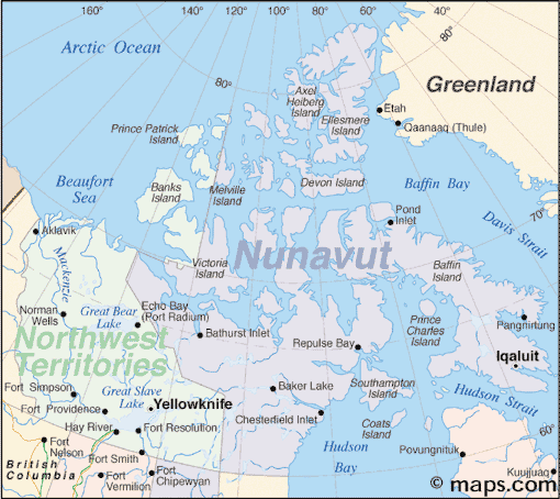
Northern Canada: Nunavut and a New View of Community Mapping
The writer and his wife, Heather Stewart visited grandchildren
in Iqaluit for three weeks in April
During the first week in Iqaluit, we went to a public lecture by David Pelly on his new book ‘Ukkusiksalik. the People’s Story’. Ukkusiksalik is a new national park around Wager Bay however Pelly focuses on the oral tradition of the Kivalliq Inuit of that region. People lived on the land, and not in ‘communities’. In mapping the land use, he shows ‘fuzzy boundaries’ of use. There are no boundaries or property lines imposed on the landscape. In the words of one of the elders, Mariano Aupilarjuq: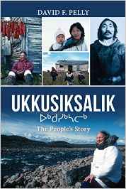
‘This is our land, this is our home, which means that it actually ties up our lives and we become one’.
In the last few years, there has been much discussion about the fate of the Franklin expedition. David Woodman wrote a seminal book on ‘Unravelling the Franklin Expedition. Inuit Testimony’. In the second edition (2015), after the rediscovery of the Erebus, he reaffirms the importance of the Inuit oral tradition. Stories that have been passed down through generations since the mid- eighteenth century. Much of this research was conducted by Louie Kamookak, Inuit historian.
In both these books, it is interesting to contemplate the meaning of ‘community mapping’, and the use of Inuit and European place names. The Inuit names are much more descriptive of the landscape. First, consider the size of the territory and the low density of human occupancy. Second, it is important to appreciate that ‘community’ is a recent Western concept, the activities of family groups was determined by access to the resources on the land and water I.e. caribou, Arctic char, seals. Human movements were related to fluctuations in the fish and wildlife populations. Presence on the land was a function of food availability.
Pelly, interviewed for Nunatsiaq News (April 22/16)
‘The first half of the book holds the first person accounts of those interviewed, while in the second half the author weaves collected stories together that are connected by common elements.
Together the two parts of the book show the spirits of the people who traveled through and lived in the area, remain a fundamental part of the landscape, their stories woven in time and space’.
‘The elders, the knowledge-holders, I think understood the value of old stories as reflections of where they had come from and who they are’.
Footnote:
If you are looking for books for grandchildren, check out Inhabit Media at www.inhabitmedia.com For example, The Legend of the Fog. By Qaunaq Mikkigak and Joanne Schwartz, 2011.
References
David F. Pelly. 2016. Ukkusiksalik. The People’s Story. Dundurn Press.
David C. Woodman. 2015. Unravelling The Franklin Mystery. Inuit Testimony. MQUP second Edition


What are communities? Where are our stories? You raise two great questions geographers must appreciate.
I recently presented “Tell a Better Story (than the guy next door)” to an organization whose main function, I argued, was the community’s storyteller — the local museum. Sure, they display artefacts but without story there is no context — no people, no geography, no place.
“Story maps” that are in vogue these days, if done right, perhaps go beyond showing artefacts (map symbols) and include stories that put us in context with our land, our people and our history. If we study and learn from the Inuit knowledge-holders, the First Nations storytellers, that Bob Maher illustrates, perhaps we can create even better digital “story maps”.
There is no real Inuktitut word for History only Unikkaat which means “story”. Everything we know about the past comes from stories, even a footprint in the snow tells a story. As Louie Kamookak showed us, the Erebus was found not far from a place Inuit called Umiaqtalik, which means “has a boat”. It was great to meet you in Iqaluit Bob, keep up the great Blog posts!