
I have often wondered how marine navigation works on a roadless map of open seas and oceans. Let’s dive into the intriguing story of marine navigation by looking at the history, modern marine navigation using GNSS (Global Navigation Satellite System), and the autonomous future.
Past
The history of marine navigation is vast. From a time when people used celestial bodies to plot their location and plan their route, mariners refined their methods by adding other elements of the open waters like sea birds, winds, and waves to develop rudimentary and yet surprisingly accurate marine navigation systems.
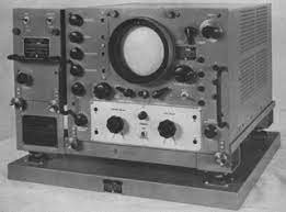
An effective method like Dead Reckoning, which was purely dependent on three variables -the speed of the boat, the direction of travel, and the amount of time passed was famous amongst seafarers. The Mariner’s compass was the earliest navigation tool used. Navigation charts, chronometers followed by radio navigation, RADAR and LORAN were setting up the next big breakthroughs in the evolution of marine navigation systems.

Present
Thankfully, navigating the waters today is much easier due to the Global Positioning System (GPS). Over the last few decades, doubling of computation power and modern satellite systems has brought location accuracy down to a few meters. GNSS supplies accurate and reliable positioning using Differential GPS (DGPS) not only for ocean navigation but also on port approaches as well as inland waterways and restricted waters.
Local and commercial fishing fleets rely on GPS to navigate to correct fishing locations and track fish migration. With millions of containers shipments being placed in port terminals annually, GPS has significantly reduced the number of lost or misdirected containers and lowered associated operation costs. It is hard to get lost nowadays. The marine industry is witnessing a renaissance of automation on both open seas as well as inland waters. Autonomous operation systems with high precision sensor image analysis systems and infrared cameras can detect other ships even in darkness and can avoid collision on the water.
The most sophisticated navigation application with features like nautical charts, 3D views, and satellite images necessary for safe and efficient navigation gives you the most realistic experience of your voyage.
- Wind-powered ships like Ocean Bird cut down the carbon emission to 90% and cross the Atlantic Ocean in 12 days, which makes it a highly efficient way of traveling on water.

- Shipbuilding company Samsung Heavy Industries (SHI) has completed the demonstration of a new ship collision avoidance system, known as Samsung Autonomous Ship (SAS). Under the demonstration, SHI’s independently developed remote autonomous navigation system stopped two autonomous ships from colliding by alerting each other in the sea.
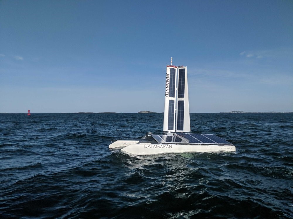
- DATAMARAN is an ocean robot that is powered by wind and solar energy. It is a low-cost and intelligent platform for sensing, communication sophisticated navigation, and self-deploying software. It is an excellent platform for ocean surveying, networked fleet, and plays the role of a ‘mothership’. Unmanned, this ocean-going robot is highly sophisticated.
Future
The only constant is change – as a result, technology is ubiquitous in our lives. Innovative technology is at our fingertips doing away with sometimes slow and messy software or a laborious paper-intensive method. With computers mimicking the capabilities of the human mind to generate better decisions and problem-solving abilities.
- AI-Powered marine navigation systems and autonomous shipping will soon be a reality. Unmanned vessels with intelligent software and advanced ship-to-shore connectivity will promote autonomy in shipping.
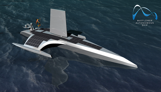
(Source: https://techcrunch.com/2019/10/16/autonomous-mayflower-research-ship-will-use-ibm-ai-tech-to-cross-the-atlantic-in-2020/)
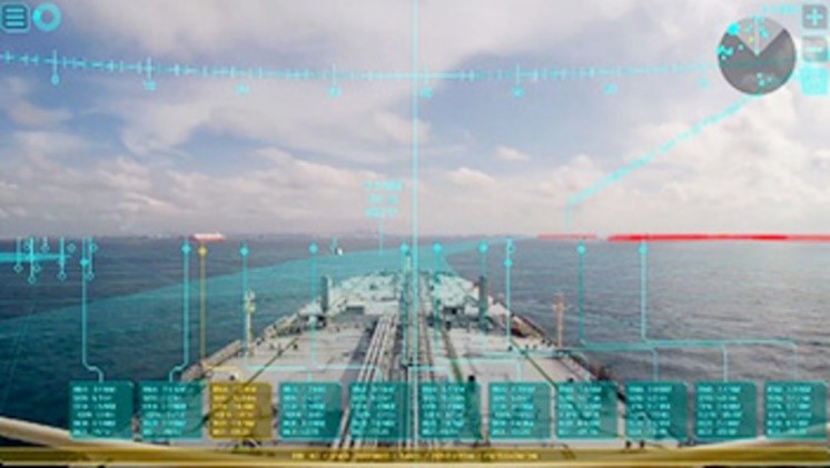
- Augmented Reality in the maritime industry draws a graphical representation of the front view of a boat/vessel, on a screen by adding extra elements. This allows you to see adverse weather conditions, clearly see the routes related to your boat as well as other boats. Hence, the best situational awareness and coordination between captain and crew are achieved.
- Electric and self-propelled fully autonomous container ships are being assessed and getting ready for commercial shipping with very few to no crew members on board. Significantly less carbon emission and replacing thousands of trips of trucks per year, this new navigation trend is rapidly gaining power.
In conclusion, while there are plenty of legal and financial hurdles at present the progress made in the autonomous shipping sector is phenomenal. While there is a long way to go unmanned vessels will soon become everyday reality much like autonomous cars.
References:
Formula Boats. June 27th , 2019. History of Navigation at Sea: From stars to the modern-day GPS. Retrieved from: https://www.formulaboats.com/blog/history-of-navigation-at-sea/
LORAN – Wikipedia. Retrieved from: https://en.wikipedia.org/wiki/LORAN
SHIP Technology. Sep 7th, 2019. SHI completes demonstration of remote autonomous navigation system. Retrieved from :https://www.ship-technology.com/news/shi-autonomous-navigation-system/
Septentrio. Top 3 Positioning Challenges in Autonomous Marine Navigation. Retrieved from: https://www.septentrio.com/en/learn-more/insights/top-3-positioning-challenges-autonomous-marine-navigation
SSPA. Autonomous Navigation of Ships. Retrieved from: https://www.sspa.se/safety-security-and-risk/autonomous-navigation-ships
AMS, Autonomous Marine System INC. DATAMARAN – A Satellite for the seas. Retrieved from : https://www.automarinesys.com/
IBM, Automation. A Mayflower to advance the promise of AI and automation. Retrieved from: https://www.ibm.com/cloud/automation/mayflower-autonomous-ship
Daily Maritime News, May 29th, 2020. Research for Augmented Reality in the Maritime Industry. Retrieved from: https://maritimecyprus.com/2020/05/29/research-for-augmented-reality-in-the-maritime-industry/
Lavars N. New Atlas, Nov 21st, 2021. MARINE – World’s first electric autonomous cargo ship takes to the water. Retrieved from: https://newatlas.com/marine/worlds-first-electric-autonomous-cargo-ship-yara-birkeland-debut/


Be the first to comment