

Take the Survey: Dutch students study Canadian Geospatial Data Infrastructure (CGDI)
Last week I saw a tweet that caught my attention from Europe. Four students taking the Geographical information management and…
Mapping at McGill, Geospatial Index, Niagara Region, Elaine Dawson, Kamloops Transit, Konsberg Geospatial: Your Canadian Geomatics Briefing for May 2nd
In the Canadian geomatics sector this week, we look at the Geospatial Readiness Index, big data, new mapping initiatives, and…

MDA and Nanowave join forces to produce an innovative radar satellite payload
MONTREAL, MDA, a Maxar Technologies company (formerly MacDonald, Dettwiler and Associates Ltd.), (NYSE: MAXR; TSX: MAXR), today announced that it…

Interview with Ted MacKinnon: One of Nova Scotia’s most valuable geospatial resources
“Oh the Places You will go!” Part 3: “Continuing the COGServation” I’ve been writing a series of articles and interviews…

Urthecast, Maxar, Climate Atlas, Hybrid GIS, ArcticDEM: Your Monday Briefing
In the news: Climate data and those who can access it, LiDar mapping at work in the Okanagan, and Business…

La révolution des données d’élévation du CCCOT, partie 2: ArcticDEM
Avec une superficie de plus de 4 millions de km² au nord du 60e parallèle, le Canada possède une des…

Careers In Land Surveying
Land surveying is an exciting Geomatics Career Field that is in high demand and often over looked by many young people…
Traces of the Past: 1917 Vimy Ridge Map Project Video Presentation GoGeomatics in Ottawa
Bert de Bruijn is an Ottawa IT security consultant and founder of the WikiWar Project. Bert is passionate about Crowdsourcing…

CCMEO’s Elevation Data Revolution: Part 2 – ArcticDEM development
With more than 4 million km² of land above the 60th parallel, Canada has one of the largest Arctic regions…

2018 Energy Prospectors Expo (EPEX) will be held May 14-15 London, Ontario
Are you a GIS professional working or aiming to work in the Natural Resources Sector? This year’s Energy Prospectors Expo…
COGS Hosts: 43rd Canadian Cartographic Association Conference May 30 – June 1st
Title: Canadian Cartographic Association (CCA) meets at the Centre of Geographic Sciences (COGS), Lawrencetown. May 30 – June 1st. For…
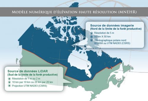
La révolution des données d’élévation du CCCOT a commencé: nouveau MNÉ du Canada
Ohé le Canada: il est de nouveau temps de s’exciter sur les données d’élévation! Pendant des années, si ce n’est…
