
The Reality Capture program offers attendees a unique opportunity to explore cutting-edge tools and techniques used in representing the real world in digital form. Experience a deep dive into reality capture and explore the latest advancements in 3D scanning, photogrammetry and LiDAR, revealing how these innovations redefine industries from architecture to virtual reality.
Presentations & Discussions
Deep Learning for Geospatial Data – A Hands-on Workshop
This workshop will cover the basics of deep learning: What is deep learning? A typical workflow using deep learning technology to identify objects (hands-on). Issues to be aware of when using deep learning technology. Options for deep learning tools.
The Evolving Landscape of Reality Capture: Challenges, Digital Twins & the Future
This session aims to unpack the intricacies of current challenges, explore the intricacies of the digital twin concept, and envision the future trajectory of reality capture. As we look to the horizon, the panel will delve into the burgeoning possibilities and innovations expected to reshape the landscape of reality capture. What breakthroughs lie ahead? How will they redefine industry standards and practices?
Maximize Operations Using a Unique Lidar That Offers Versatility & Performance
In February 2022, Balko Technologies launched the world’s first modular drone Lidar, which aims to democratize geospatial data capture by offering a versatile, easy-to-use and quick to deploy solution. This technological showcase aims to demonstrate the performance, modularity and distinctive advantages for users. In addition to these tools, a new web application called e-Connect is used to monitor the status of equipment while it is in flight. A state-of-the-art sensor allows us to capture more data in less time.
New AI Powered Tools to Increase Drone Point Cloud Deliverable Productivity
Learn how new surface modeling tools employing artificial intelligence reduce the turnaround time of point cloud surface models by 400%. Faster ground extraction routines for UAV data can be achieved without the need for classification or noise removal. In this presentation, we discuss examples including how a project yielded nearly exact results while reducing the processing time. See how this new process impacts grading routines in construction, bare earth modeling, landslide outcrop monitoring, and more.

LiDAR continues to be a cornerstone of the mapping industry. Since it’s inception the technology has evolved from sole use on manned aircraft to being used on UAVs and mobile mapping platforms. As the LiDAR industry continues to evolve, our panel of experts will discuss what current and future trends impacting this industry. Join our award-winning panelists for a an exciting discussion. Bring your questions.
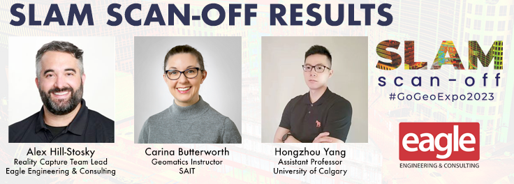
We will present a snapshot of what SLAM systems are available, as well as provide a base dataset for your independent comparison and evaluation. This presentation will explore the platforms used, give an unbiased evaluation of the data produced and the tools used, and information on where these products and their example data can be obtained by you, the Canadian industry professional, so that you can weigh this technology against your own needs against what’s available and apply accordingly.
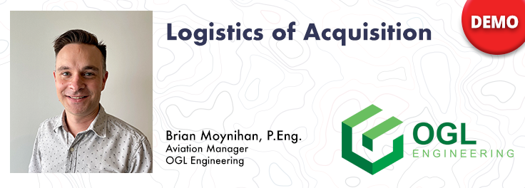
How do you decide when to mobilize and when not to, or even where can you safely and legally fly. As the frequency of unpredictable weather and forest fire smoke increase, so too does the risk in mobilizing to a job site. This presentation will demonstrate OGL Engineering’s process and different geospatial resources available to better inform your decision and minimize risks.
Canada’s SLAM Market: Applications & Considerations for Industry
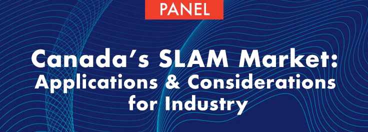
The SLAM Scan-off results are in, but what does that mean, where can this technology be applied, and what technology can be applied to it? The panel will draw on the latest research and industry insights, and will discuss the challenges, benefits and application examples of SLAM technology in various fields. We aim to provide insights and recommendations for spatial professionals and industry clients in Canada who are considering adopting (or rejecting!) SLAM technology now or in the future.
Airborne Topo-Bathymetric Lidar Combined with Thermal Imaging for Fish Habitat Studies in Rivers
Researchers have been using the airborne Leica Chiroptera 4X topo-bathymetric lidar sensor for nearly a decade and have surveyed coastal, riverine and lake environments. The topo-bathy lidar provides stream bed bathymetry and depth for fish passage and the thermal data and drone imagery provides insights into fish habitat. The results of this analysis can provide river stewardship groups the insights they need for possible restoration projects and impediments to fish passage.


Be the first to comment