
The COVID-19 pandemic has impacted various industries globally. Among these industries, the oil and gas sector took a blow while it had been already reeling from the 1999 collapse of the consumer value of oil. Now we see some historic low prices for oil. The oil and gas sector has been forced to dismiss a huge amount of workforce from the field as it tries to retain essential workers for periodic monitoring and maintenance of project activities and infrastructure assets.
Remote work and social distancing has accelerated remote sensing technology in setting up virtual models and visualization solutions that utilize a combination of different imaging platforms such as satellite imageries, UAVs and LiDAR.
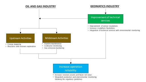
Looking ahead o the future Geomatics professionals are in a unique situation. Organizations are expected to reduce the workforce in the oil and gas field, but it will require remote supervision of both its upstream and midstream activities. This has created the opportunity for the Geomatics Industry to capitalize on revolutionizing its platforms and technical service schemes in agreement with the recent needs of its clients.
The Opportunity
For the upstream activities of the oil and gas sector, this is a suitable time to gauge the untapped oil and gas resources by detailed remote resources and reserves exploration. This initiative can provide the country with a detailed geo-information and a supply chain map for its future reserves estimates of crude oil and refined products. Therefore, it can reduce the opportunity costs that arise from mobilization and demolition activities that may be needed during the forthcoming project expansions, and provide a great deal of product transportation programs towards the locations of established refineries. In addition, this can also improve the net value and future cash flow of these enterprises. On the other hand, remote sensing technology also plays a key role in the industry’s midstream activities.
Remote monitoring can deliver pre-emptive maintenance plans over infrastructure assets; therefore, it can reduce the occurrence probability of technical problems, which leads to a decline in equipment breakdown cost. At present, the prolonged idle condition in the field provides these enterprises ample time to have a full-scale transition to remote sensing technology application over their selected project operation components. Whereas the geomatics service providers can further investigate and improve their sensor resolutions and platform flexibilities as well as practically integrate its technical services with environmental monitoring.
In Canada, several big oil and gas players have been using remote sensing technology in environmental and pipeline leakage monitoring, continuous development of its infrastructure assets and leading their contractors remotely. Companies like Stantec and Suncor Energy are frontrunners in this initiative. For instance, Stantec is currently deploying dove satellites to capture its pipeline system’s physical condition and uses vegetation indices as indicators of potential leakage nearby. On the other hand, Suncor Energy uses drones for equipment inspection and maintenance. In the future, the growing demands in remote sensing technology in different sectors of the society can possibly reduce its financial contribution to the operating cost of interested groups.
Meanwhile, the application of remote sensing technology both in the small and big players has a potential role in improving the energy-trade of Canada with its market partners. The improvement of upstream activities with the aid of remote sensing and geomatics can rationalize the geographical distribution of its crude oil and refined petroleum product reserves and assist Canada enhancing profitability. This may also justify the construction of additional refineries in the country, which can provide added value to our oil and gas products, stabilize our export demand from our partner countries under the USMC Agreement and increase our market control. In addition to this, remote sensing technology can simultaneously deliver environmental monitoring services to ensure that gas emission level throughout the infrastructure assets follows the regulatory guidelines. The question now is how far the cost of remote sensing will drop in the future to substantiate its inclusion in the oil and gas field operations.
Sources:
https://sustainability.suncor.com/en/innovation/digitalization#remotesensingtechnologies
https://www.cer-rec.gc.ca/nrg/sttstc/crdlndptrlmprdct/rprt/2019gslnrprt/index-eng.html
https://www.csis.org/analysis/mapping-us-canada-energy-relationship


Be the first to comment