
Asia
Canadian Cartography: GoGeomatics Edmonton Visits the University of Alberta Map Library & Collections
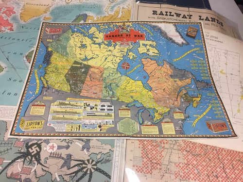
Last night the Edmonton GoGeomatics Group had the chance to explore the amazing collection of historic maps at the University…
Airobotics Selects SimActive’s Photogrammetry Software for its Automated Industrial Drone Solution
Montreal, Canada, August 30th, 2016 – SimActive Inc., a world-leading developer of photogrammetry software, is pleased to announce that Airobotics…
PCI Geomatics Delivers High Volume Production System (GXL) to Skymap Global in Singapore
MARKHAM, Ontario, Canada—May 25, 2016: PCI Geomatics, a world leading developer of remote sensing and photogrammetric software and systems, announced…
Teledyne Optech a sponsor at 2015 Asian Conference on Remote Sensing
October 14, 2015 — Teledyne Optech is pleased to announce we are a sponsor at the Asian Conference on Remote…
PlanetSAT 15 L8: the new up-to-date, homogeneous and natural colour imagery base map with 15-meter resolution.
The French company PlanetObserver, specialized in imagery base map production for more than 25 years, announced the coverage of more…
Montreal: AeroVironment Chooses SimActive’s Correlator3D™
Montreal, Canada, September 22nd, 2015 – SimActive Inc., a world-leading developer of photogrammetry software, is pleased to announce that AeroVironment…
Global Commercial Drone Market to Reach $2.07 Billion by 2022
The global commercial drone market size is expected to reach USD 2.07 billion by 2022, according to a new report…

Canada Day Came Early at the Canada Aviation and Space Museum
June 23rd marked a special day in the history of aviation and space in Canada. A very special aircraft, a…

Point, Hub, Link, Node: The Unique Geography of Airports & Pearson
When we go to the airport, do we really ever consider where we’re going? To most of us, even those…
SimActive Provides Integrated LiDAR and Photo Solution to Altoa
Montreal, Canada, June 2nd, 2015 – SimActive Inc., a world-leading developer of photogrammetry software, is pleased to announce the purchase…

Intelligent Networking and Advice to Enter the Geospatial Workforce
This editorial is in response to and in support of a recent article written by Kirsti Oja on the GoGeomatics…
Intelsat and Azercosmos Partner to Deliver New Satellite at 45 Degrees East
LUXEMBOURG & BAKU, Azerbaijan–Intelsat S.A. (NYSE: I), the world’s leading provider of satellite services, and Azercosmos OJSCo., the national satellite…
