
Enterprise

Canadian BIM and Digital Twin Digest for July 28th, 2022
BIM Contracting and Infrastructure Digital Twins Businesses can improve on operating infrastructure assets by changing the way they use BIM…

Digitalizing Construction Crews – The Last Gap in the Design>As-Built>GIS Workflow
Utility digital transformation already driven by demand for Distributed Energy Resources (DER) and Advanced Distribution Management System (ADMS) has recently…

GeoIgnite 2020: Growing Canada’s Next Earth Observation (EO) Generation
GeoIgnite is Canada’s National Geospatial conference hosted by GoGeomatics Canada. GeoIgnite was held online using Zoom July 22nd to 24th,…
MDA to Acquire DigitalGlobe, Creating Industry Leader in End-to-End Space Systems, Earth Imagery and Geospatial Solutions
San Francisco and Westminster, Colo. – MacDonald, Dettwiler and Associates Ltd., a global communications and information company providing technology solutions…
Planning an Enterprise GIS from the Bottom Up
You might be an observant professional in a department that uses GIS. Your organization may be large and have many…
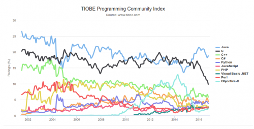
What are the Top Programming Languages in the GIS World?
Image source: www.tiobe.com Every now and again we hear about the importance of programming for Geographic Information Systems(GIS) professionals, that…
NB 911 Bureau Receives Esri Canada Award of Excellence in GIS
FREDERICTON, Esri Canada User Conference – October 25, 2016 – Esri Canada today presented the NB 911 Bureau, a branch…
Government of Yukon Wins 2016 Esri Special Achievement in GIS Award
SAN DIEGO, Esri User Conference—June 29, 2016—Esri Canada congratulates the Government of Yukon for receiving the 2016 Esri Special Achievement…
TECTERRA Funds $4.9 Million for Geomatics Innovation in Canada in 2015-16
TECTERRA Inc. announced it had committed $4.9 million of funds to support the geomatics technology sector in Canada during the…

GIS Certification: Options and Discussion
There are many GIS and geomatics certification options available to Canadians. They have been discussed in detail in previous articles. …
Canadian Municipalities Unlock Their Data with Esri’s ArcGIS Open Data
TORONTO—April 25, 2016—Esri Canada today announced that more than 20 Canadian municipalities have adopted ArcGIS Open Data. Esri’s cloud-based geographic…
GIS Certification: Esri Certification
Many GIS Certification options exist for Canadian geomatics professionals, including software-specific certifications. One popular software certification is the Technical Certification…
