
GIS

Join us for the “Day of Geography” – Nov 17, 2014
Back in January 2014, as I was catching up on episodes of the CRM Archaeology podcast hosted by Chris Webster,…
Esri Canada Launches GIS Centres of Excellence in Higher Education
TORONTO – July 29, 2014 – Esri Canada, the leading provider of geographic information system (GIS) solutions, is pleased to…
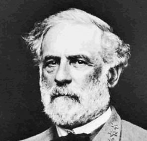
Gettysburg: What Could Lee See?
In an age devoid of modern communications methods and digital maps, military generals often made tactical decisions based on what…
Content and Growth of Municipal Open Data Catalogues
The open data movement has been the talk of the nation, encouraging transparency of governance and good management of data.…
St-Isidore, Ontario: ING Robotic Aerial Mapping / Precision Agriculture
ING Robotic Aviation is partnering with ASG Mapping to rigorously assess and develop the application of small robotic aircraft systems…

Canadian Geomatics Twitter Channels: Friends with Benefits
This piece is generated by my experiences with my own account @RebelGeo and as Tweeter for Canadian Geographic Education @CanGeoEdu.…
Auracle Geospatial Science Announces Partnership with Skybox Imaging
Auracle Geospatial Science, a Canadian remote sensing company, is pleased to announce that it has signed an agreement with Skybox…
MDA to provide operational parcel map solution to the Land Title and Survey Authority of BC
RICHMOND, BC, Jul 7, 2014 — MacDonald, Dettwiler and Associates Ltd. (“MDA” or the “Company”), a global communications and information…

Wrapping Up a Year of Toronto Socials
It’s been a great year for socials in Toronto, and we’re taking the summer off to plan how we can…

All the Geomatics Acronyms You Wanted to Know but were Too Afraid to Ask
Here in Canada, there are many geomatics acronyms that get tossed around. During the recent “Team Canada” event that the…

Another Great Year of Niagara Socials
GoGeomatics Canada is looking back on another successful year in socials. To help us out, we caught up with Darren…
Product Launch – Geomatica 2014 from PCI Geomatics
GoGeomatics Canada recently attended the launch of PCI Geomatics’ latest version of Geomatica 2014, the integrated desktop image processing software.…
