• facebook
  • Twitter
  • Linkedin
  • Youtube
  • Linkedin Group
  • Post a Job
  • Post an Ad
  • Post an Event
  • Post a Directory Listing
  • Post a Press Release
  • Media Kit
  • My Account
  • Login
GoGeomatics
  • MAGAZINE
    • BIM & GIS
    • Community
    • Conference news
    • Earth Observation
    • Education & Careers
    • GEOAI
    • Announcements
    • Reality Capture & Lidar
    • Science
    • Technology
  • Directories
    • ASSOCIATION
    • INDUSTRY
    • EDUCATION
    • Open Data
  • EVENTS
    • GeoIgnite Events
    • Events Calendar
    • GoGeomatics Meetups
  • Services
    • Advertising
    • Marketing
    • Post a Job
    • Post an Ad
    • Post an Event
    • Post a Press Release
    • Post a Directory Listing
    • Media Kit
    • Web Design
  • Find a Job
  • Volunteer
    • Start a GoGeomatics Group
    • Editors & Writers Group
  • About Us
    • About Us
    • Contact Us
    • Frequently Asked Questions
  • Videos
HomeGlacier

Glacier

||||||
Technology

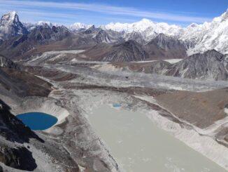
Canadian Geospatial Briefing May 10th: Developing Tools to Protect Canada’s Biodiversity; Tracking impact of industrial projects on B.C. species at risk; 3D satellite mapping shows that glaciers are melting faster than ever; Geospatial Maturity Index shows that Calgary is a leader in GIS programs; Community engagement to measure impact of climate change on coastal environments in the Estuary and Gulf of St Lawrence; Surprising locations in Canada that have seen the largest increase in house prices

10 May 2021 GoGeomatics Canada | 3D Mapping

Carleton and Partners Developing Tools to Protect Canada’s Biodiversity Dr. Joseph Bennett, a biology professor at Carleton University and his team will develop support tools that will assist partner organizations with prioritizing resources to help […]

Glacial Lakes||||
Technology

Your Canadian Geospatial Briefing for September 7th: UofC’s research on glacial lakes; Canadian youth in space sector; Remote Sensing reasons out orange dusting in N.W.T; USask’s AI contribution to agriculture; Calgary woman’s Park story map

7 September 2020 GoGeomatics Canada | Artificial Intelligence

Dramatic growth reported in glacial lakes – A study by University of Calgary Dr. Dan Shugar, an associate professor at the University of Calgary and the lead researcher for this study, along with his team […]

Technology

Video: How We Measure Glaciers (Byte-Sized Science)

13 September 2019 GoGeomatics Newsmakers | Canada

Canada’s landmass and climate supports approximately 20% of the Earth’s glacier ice volume excluding the Antarctic and Greenland ice sheets. Outside of the ice sheets of Antarctica and Greenland, Canada has more glacier coverage in […]

Events

Notice
There are no upcoming events.

View All Events

Services

  • Post a Job
  • Post an Ad
  • Post an Event
  • Post a Directory Listing
  • Post a Press Release
  • Media Kit
  • My Account
  • Login

Jobs

Post a Job
  • Canada Maps and Poster Gallery Volunteer Leads — GeoIgnite 2026
    remote
  • GIS & Data Analytics Lead
    Beaumont, AB
  • Lead Surveyor, Projects/Arpenteur-géomètre principal, projets; arpenteuse-géomètre principale, projets
    North Bay, Thunder Bay
  • Senior GIS Developer
    Calgary, AB
View All Jobs
  • Directories
    • Associations Directory
    • Industry Directory
    • Education Programs
    • Open Data
  • Volunteer
    • Start a GoGeomatics Group
    • Editors & Writers Group
  • About Us
    • GoGeomatics Media Kit
    • Who We Are
    • Contact Us
    • FAQ’s
    • Advertising
    • Marketing
  • Subscribe
GoGeomatics
GoGeomatics is the largest and most popular communications hub promoting the Canadian geospatial community. The business was incorporated in 2011. GoGeomatics hosts over 100 fun, free, location technology networking events each year in cities across Canada.

© 2025 GoGeomatics

  • facebook
  • Twitter
  • Linkedin
  • Youtube
  • Linkedin Group